
Difference between revisions of "Physical Environment: Belesia"
(Added terrain map) (Tag: Visual edit) |
m (Put Diseases & Animals into a table) (Tag: Visual edit) |
||
| (17 intermediate revisions by 7 users not shown) | |||
| Line 1: | Line 1: | ||
| − | + | <div style="font-size:0.9em; color:#333;"> | |
| + | [[Pacific|DATE Pacific]] > [[Belesia]] > '''{{PAGENAME}}''' ←You are here | ||
| + | </div><div style="float:right;margin-left:15px;">__TOC__</div> | ||
| + | |||
[[File:Belesia terrain map.PNG|thumb|Physical Map of Belesia]] | [[File:Belesia terrain map.PNG|thumb|Physical Map of Belesia]] | ||
| − | |||
| − | == Table of Physical Environment Data == | + | == Physical Environment Overview == |
| + | Belesia is a small country located in an archipelago in the western Pacific Ocean. It borders South Torbia and Gabal—with whom it has friendly relations. The country’s terrain consists primary of forested mountains interspersed with low valleys. The valleys are typically fertile and comprise most of Belesia’s arable land. Both vegetation and climate are tropical in nature. Multiple natural hazards exist, resulting from the country’s geology, weather, native wildlife, and human activity. | ||
| + | |||
| + | '''Placeholder for new Physical map of Belesia after the border change''' | ||
| + | |||
| + | == Table of Physical Environment Data == | ||
{| class="wikitable" | {| class="wikitable" | ||
| − | + | | colspan="3" |'''Physical Environment Data''' | |
| − | + | |- | |
| − | + | |'''Measure''' | |
| − | + | |'''Data''' | |
| + | |'''Remarks''' | ||
| + | |- | ||
| + | |Land Area (km<sup>2</sup>) | ||
| + | |258,807 | ||
| + | |Includes inland water | ||
| + | |- | ||
| + | |Land Border (km) | ||
| + | |253 | ||
| + | |South Torbia | ||
|- | |- | ||
| − | | | + | |Coastline (km) |
| − | | | + | |30,662 |
| − | | | + | | |
| − | |||
|- | |- | ||
| − | | | + | |Highest elevation (m) |
| − | | | + | |4,046 |
| − | | | + | |Mount Kinabalu |
| − | |||
|- | |- | ||
| − | | | + | |Lowest Elevation (m) |
| − | | | + | |0 |
| − | | | + | |Sea Level |
| − | | | + | |- |
| + | |Arable (cultivated) Land (%) | ||
| + | |27% | ||
| + | | | ||
| + | |- | ||
| + | |Permanent Crops (%) | ||
| + | |17% | ||
| + | | | ||
| + | |- | ||
| + | |Permanent Pasture (%) | ||
| + | |<1% | ||
| + | |5% grasslands could be used for pastoral purposes | ||
| + | |- | ||
| + | |Irrigated Land (%) | ||
| + | |<1% | ||
| + | | | ||
| + | |- | ||
| + | |Forested Land (%) | ||
| + | |36% | ||
| + | |Conifers (1%); Rainforest (24%); Other (12%) | ||
| + | |- | ||
| + | |Urban Areas (%) | ||
| + | |<1% | ||
| + | | | ||
| + | |- | ||
| + | | colspan="3" |'''Legend''': kilometer (km); meter (m) | ||
|} | |} | ||
== Terrain == | == Terrain == | ||
| − | + | Belesian territory encompasses over 2,000 islands. It is part of a larger archipelago bounded by the Philippine Sea to the east, the South China Sea to the west, and the Celebes Sea to the south. Belesia shares land boundaries with South Torbia to the north and another country to the southeast, but only maritime borders with its other neighbors, including Gabal. | |
| − | + | Belesia’s major islands are Bohol, Borneo, Cebu, Leyte, Luzon, Masbate, Mindanao, Negros, Panay, and Samar, 11 in all. While the country possesses most of these in its entirety, it shares Luzon with both North and South Torbia, and possesses less than one-tenth (8%) of Borneo. Lesser islands include Biliran, Burias, Catanduanes, Dinagat, Marinduque, Siargao, Sibuyan, Tablas, Ticao, the Cuyo Islands, and the Sulu Archipelago. | |
| + | |||
| + | The islands are mountainous in nature, with interspersed lowland valleys and low coastal plains on the larger islands. Major geographic features include the Bicol Peninsula and the Mayon Volcano (Luzon), Mount Apo (Mindanao), the Chocolate Hills (Bohol), the Zamboanga Peninsula (Mindanao), and the Crocker and Trus Madi Mountain Ranges (Borneo). Surface and subsurface caves are common in the archipelago. | ||
| + | |||
| + | '''Placeholders for maps of the various islands; 6 previously on ODIN''' | ||
| + | <gallery> | ||
| + | File:Belesian Luzon.PNG|Belesian Luzon terrain map | ||
| + | File:Samar and Masbate.PNG|Samar and Masbate Islands, Belesia, terrain map | ||
| + | File:Panay Negros Cebu Bohol Leyte.PNG|Panay, Negros, Cebu, Bohol, and Leyte Islands, Belesia, terrain map | ||
| + | File:Mindanao.PNG|Mindanao Island, Belesia, terrain map | ||
| + | File:Belesian Borneo.PNG|Belesian Borneo terrain map | ||
| + | </gallery> | ||
== Bodies of Water == | == Bodies of Water == | ||
| − | + | [[File:Major Belesian Islands and Bodies of Water.PNG|thumb|Major Belesian Islands and Bodies of Water]] | |
| + | Belesia is surrounded by bodies of water. The South China Sea lies to its west, the Philippine Sea to its east, and the Celebes Sea to its south. The Sulu Sea is nearly encompassed by the country, with Gabal and South Torbia lying on its far northern edge. The country is separated from Gabal by the Sulu Sea. It also shares Tablas Strait, Tayabas Bay, and Lamon Bay with South Torbia. It also possesses numerous smaller seas, gulfs, bays and straits. | ||
| + | Multiple rivers and a few small lakes exist on the islands, with the former being drainage for many mountain ranges. Due to the mountainous terrain, most rivers are navigable only by shallow-draft vessels (less than 1 meter) for short distances—if at all. | ||
| + | |||
| + | '''Placeholder for Bodies of Water Map''' | ||
== Mobility Classification == | == Mobility Classification == | ||
| − | + | Movement in Belesia is difficult due to the mountainous island nature of the country. Water or air transport methods are required to and between islands. Once on land, mountain ranges and steep river gorges naturally canalize movement. Heavy rains, flooding, and mud/landslides can seriously hamper troop movement during the rainy season. The presence of forests at higher elevations limits mobility and provides cover for enemy forces and smugglers, while multiple rivers and streams challenge mechanized and motorized movement in the valleys. Air operation impediments include mountain ranges, forests, steep valleys and gorges, clouds/fog/haze, aircraft icing at high altitudes, and cyclonic storms. | |
| + | |||
| + | == Subterranean Environment == | ||
| + | The islands are full of caves, both above and below sea level. One of the most famous of these is the Odloman Cave on Negros Island, which is equally long. In addition to the multitude of naturally occurring caves, past and current mining on the islands has produced networks of manmade tunnels. Higher-level tunnels and caves are sometimes used as emergency shelters by local residents during and after larger cyclonic storms. | ||
| + | |||
| + | == Vegetation == | ||
| + | Around 36% of Belesia is forested, primarily consisting of rain forest in the mountainous areas. While coniferous pines are found at the highest elevations, most trees are broadleaf varieties such as balau, meranti, and narra; other plant species found in montane forests include bamboo, ferns, orchids, and climbing palms (rattan). Due to the country’s climate, trees keep their leaves year round. The lowland valleys are devoted almost completely to agriculture, while the forested areas are confined to the mountains. Small mangrove swamps can be found on some of the coastline. | ||
| − | + | == Agriculture == | |
| + | Most agriculture is concentrated in lowland valleys, with over half of this land dedicated to annual crops. Permanent crops include abaca, agave, banana, cacao, cashew, citrus fruit, coconut, coffee, lemon, maguey, mango, oil palm, pineapple, papaya, other fruits, and rubber, while annual crops are beans, cabbage, camote, cassava, corn, cotton, eggplant, garlic, onion, peanut, sweet potato, rice, sugarcane, tobacco, tomato, and vegetables. The country’s main crops are rice, coconut, corn, pineapple, other fruits, abaca, palm oil, and sugarcane. Agricultural exports include abaca, banana, coconut, palm oil, pineapple, rubber, sugarcane, and other fruits and vegetables. | ||
| + | |||
| + | Belesians have some livestock, especially in regions where crop cultivation is more difficult. Common domesticated animals include cats, cattle, dogs, goats, horses, pigs, poultry, and water buffalo. The country also possesses multiple types of wildlife, including bat, bearcat, civet cat, crocodile, deer, elephant, lemur, mice, mongoose, monkey, monitor lizard, orangutans, rhinoceroses, scaly anteater, squirrel, sun bear, tapir, tiger, wild boar, wild ox. The country has several national parks, designed to protect the flora and fauna found on the islands. | ||
| + | |||
| + | == Climate and Weather == | ||
| + | [[File:DATE Pacific Subregional Climate map.PNG|thumb|Placeholder for Koppen-Geiger Climate Map]] | ||
| − | == | + | === Climate Map === |
| − | + | Belesia experiences four different climate types that can be broken into two broad categories. Three are considered tropical climates and the fourth, a temperate climate, is only found at higher elevations. These are small pockets that are situated in amongst the other climates. | |
| − | + | Winds follow a distinctive northeast, east, southwest cycle (NE monsoon, easterlies, SW monsoon) that corresponds to—and causes—the country’s seasons. The coolest part of the year falls during the northeast monsoon, while the warmest temperatures occur during the easterlies. Relative humidity is high year-round, although relatively lower inland, at higher elevations, and during the evenings. | |
| − | + | '''Placeholder for Koppen-Geiger Climate Maps-May need more than one map''' | |
| + | {| class="wikitable" | ||
| + | | colspan="5" |'''Köppen climate classification''' | ||
| + | |- | ||
| + | |'''Zone''' | ||
| + | | colspan="2" |'''Precipitation Type''' | ||
| + | |'''Heat Type''' | ||
| + | |'''Acronym: Description''' | ||
| + | |- | ||
| + | | rowspan="3" |Tropical Climate | ||
| − | == | + | (Zone A) |
| − | + | | colspan="3" |Rainforest (f) | |
| + | |Af: Tropical rainforest climate with an average precipitation of at least 2.36 inches of rain in every month. This is the most prevalent climate in Belesia covering most of or major sections of most islands. | ||
| + | |- | ||
| + | | colspan="3" |Monsoon (m) | ||
| + | |Am: Tropical monsoon climate with an average temperature of 64.4° F every month with significant rainfall, but driest month is around the winter solstice. This climate occurs on the western side of several islands in the western side of many islands of Belesia | ||
| + | |- | ||
| + | | colspan="3" |Savanna, Dry Winter (w) | ||
| + | |Aw: Tropical savanna climate with an average temperature of 64.4° F every month with significant rainfall. This occurs primarily on the series of islands in the far western part of the country. | ||
| + | |- | ||
| + | |Temperate Climate | ||
| + | |||
| + | (Zone C) | ||
| + | |No Dry Season (f) | ||
| + | | colspan="2" |Warm Summer(b) | ||
| + | |Cfb: Temperate oceanic climate where the coldest month averages above 32° F and all months with an average temperature below 71.6° and at least 4 months average above 50°. No significant precipitation difference between seasons. `This climate only occurs in very isolated spots at higher elevations in the southern part of Belesia | ||
| + | |} | ||
| + | |||
| + | === Seasons Overview === | ||
| + | |||
| + | ==== Seasons Chart-Davo City ==== | ||
| + | {| class="wikitable" | ||
| + | | colspan="6" |'''Seasons Chart-Davo City''' | ||
| + | |- | ||
| + | |''' ''' | ||
| + | |Temperature | ||
| + | |||
| + | Coldest (F) | ||
| + | |Temperature | ||
| + | |||
| + | Hottest (F) | ||
| + | |Precipitation | ||
| + | |||
| + | (inches) | ||
| + | |Days of Rain | ||
| + | |Wind (Average in miles per hour) | ||
| + | |- | ||
| + | |January | ||
| + | |72.3 | ||
| + | |88.2 | ||
| + | |4.3 | ||
| + | |13 | ||
| + | |4.5 | ||
| + | |- | ||
| + | |February | ||
| + | |72.5 | ||
| + | |90.1 | ||
| + | |4.1 | ||
| + | |12 | ||
| + | |6.7 | ||
| + | |- | ||
| + | |March | ||
| + | |72.3 | ||
| + | |89.6 | ||
| + | |3.1 | ||
| + | |11 | ||
| + | |4.5 | ||
| + | |- | ||
| + | |April | ||
| + | |74.7 | ||
| + | |91.4 | ||
| + | |5.9 | ||
| + | |12 | ||
| + | |4.5 | ||
| + | |- | ||
| + | |May | ||
| + | |74.5 | ||
| + | |89.4 | ||
| + | |7.9 | ||
| + | |16 | ||
| + | |4.5 | ||
| + | |- | ||
| + | |June | ||
| + | |74.5 | ||
| + | |88.2 | ||
| + | |7.7 | ||
| + | |17 | ||
| + | |4.5 | ||
| + | |- | ||
| + | |July | ||
| + | |72.3 | ||
| + | |88.2 | ||
| + | |5.9 | ||
| + | |15 | ||
| + | |4.5 | ||
| + | |- | ||
| + | |August | ||
| + | |72.3 | ||
| + | |88.2 | ||
| + | |5.5 | ||
| + | |14 | ||
| + | |4.5 | ||
| + | |- | ||
| + | |September | ||
| + | |74.8 | ||
| + | |89.4 | ||
| + | |5.7 | ||
| + | |15 | ||
| + | |4.5 | ||
| + | |- | ||
| + | |October | ||
| + | |74.8 | ||
| + | |89.2 | ||
| + | |5.5 | ||
| + | |16 | ||
| + | |4.5 | ||
| + | |- | ||
| + | |November | ||
| + | |72.0 | ||
| + | |89.4 | ||
| + | |4.7 | ||
| + | |15 | ||
| + | |4.5 | ||
| + | |- | ||
| + | |December | ||
| + | |71.8 | ||
| + | |88.2 | ||
| + | |3.1 | ||
| + | |13 | ||
| + | |4.5 | ||
| + | |} | ||
| + | |||
| + | ==== Seasons Chart-Cebu City ==== | ||
| + | {| class="wikitable" | ||
| + | | colspan="6" |'''Seasons Chart-Cebu City''' | ||
| + | |- | ||
| + | |''' ''' | ||
| + | |Temperature | ||
| + | |||
| + | Coldest (F) | ||
| + | |Temperature | ||
| + | |||
| + | Hottest (F) | ||
| + | |Precipitation | ||
| + | |||
| + | (inches) | ||
| + | |Days of Rain | ||
| + | |Wind (Average in miles per hour) | ||
| + | |- | ||
| + | |January | ||
| + | |72.5 | ||
| + | |86.4 | ||
| + | |4.1 | ||
| + | |12 | ||
| + | |5.1 | ||
| + | |- | ||
| + | |February | ||
| + | |72.7 | ||
| + | |86.7 | ||
| + | |3.1 | ||
| + | |10 | ||
| + | |5.1 | ||
| + | |- | ||
| + | |March | ||
| + | |73.0 | ||
| + | |88.5 | ||
| + | |2.3 | ||
| + | |9 | ||
| + | |5.1 | ||
| + | |- | ||
| + | |April | ||
| + | |74.7 | ||
| + | |90.5 | ||
| + | |2.6 | ||
| + | |6 | ||
| + | |5.1 | ||
| + | |- | ||
| + | |May | ||
| + | |75.7 | ||
| + | |91.4 | ||
| + | |4.5 | ||
| + | |9 | ||
| + | |5.1 | ||
| + | |- | ||
| + | |June | ||
| + | |75.4 | ||
| + | |90.1 | ||
| + | |6.9 | ||
| + | |14 | ||
| + | |5.1 | ||
| + | |- | ||
| + | |July | ||
| + | |75.0 | ||
| + | |89.4 | ||
| + | |7.6 | ||
| + | |16 | ||
| + | |5.1 | ||
| + | |- | ||
| + | |August | ||
| + | |75.2 | ||
| + | |89.4 | ||
| + | |6.5 | ||
| + | |14 | ||
| + | |5.1 | ||
| + | |- | ||
| + | |September | ||
| + | |74.7 | ||
| + | |89.1 | ||
| + | |6.9 | ||
| + | |15 | ||
| + | |5.1 | ||
| + | |- | ||
| + | |October | ||
| + | |74.5 | ||
| + | |86.7 | ||
| + | |7.6 | ||
| + | |16 | ||
| + | |5.1 | ||
| + | |- | ||
| + | |November | ||
| + | |74.3 | ||
| + | |88.3 | ||
| + | |6.5 | ||
| + | |14 | ||
| + | |5.1 | ||
| + | |- | ||
| + | |December | ||
| + | |73.6 | ||
| + | |87.3 | ||
| + | |4.8 | ||
| + | |14 | ||
| + | |5.1 | ||
| + | |} | ||
| + | |||
| + | ==== Seasons Chart-Zamboanga City ==== | ||
| + | {| class="wikitable" | ||
| + | | colspan="6" |'''Seasons Chart-Zamboanga City''' | ||
| + | |- | ||
| + | |''' ''' | ||
| + | |Temperature | ||
| − | + | Coldest (F) | |
| + | |Temperature | ||
| − | + | Hottest (F) | |
| + | |Precipitation | ||
| − | + | (inches) | |
| − | + | |Days of Rain | |
| + | |Wind (Average in miles per hour) | ||
| + | |- | ||
| + | |January | ||
| + | |74 | ||
| + | |90 | ||
| + | |3.5 | ||
| + | |7 | ||
| + | |5.1 | ||
| + | |- | ||
| + | |February | ||
| + | |74 | ||
| + | |91 | ||
| + | |2.9 | ||
| + | |6 | ||
| + | |5.1 | ||
| + | |- | ||
| + | |March | ||
| + | |74 | ||
| + | |92 | ||
| + | |2.4 | ||
| + | |6 | ||
| + | |5.1 | ||
| + | |- | ||
| + | |April | ||
| + | |75 | ||
| + | |92 | ||
| + | |2.8 | ||
| + | |7 | ||
| + | |5.1 | ||
| + | |- | ||
| + | |May | ||
| + | |75 | ||
| + | |91 | ||
| + | |3.5 | ||
| + | |12 | ||
| + | |5.1 | ||
| + | |- | ||
| + | |June | ||
| + | |76 | ||
| + | |91 | ||
| + | |3.9 | ||
| + | |15 | ||
| + | |5.1 | ||
| + | |- | ||
| + | |July | ||
| + | |75 | ||
| + | |90 | ||
| + | |4.7 | ||
| + | |14 | ||
| + | |5.1 | ||
| + | |- | ||
| + | |August | ||
| + | |75 | ||
| + | |91 | ||
| + | |4.7 | ||
| + | |13 | ||
| + | |5.1 | ||
| + | |- | ||
| + | |September | ||
| + | |75 | ||
| + | |90 | ||
| + | |4.6 | ||
| + | |13 | ||
| + | |5.1 | ||
| + | |- | ||
| + | |October | ||
| + | |75 | ||
| + | |90 | ||
| + | |6.7 | ||
| + | |14 | ||
| + | |5.1 | ||
| + | |- | ||
| + | |November | ||
| + | |75 | ||
| + | |91 | ||
| + | |4.2 | ||
| + | |13 | ||
| + | |5.1 | ||
| + | |- | ||
| + | |December | ||
| + | |74 | ||
| + | |91 | ||
| + | |2.4 | ||
| + | |10 | ||
| + | |5.1 | ||
| + | |} | ||
| − | == | + | ==== Seasons Chart-Cagayan de Oro City ==== |
| − | + | {| class="wikitable" | |
| + | | colspan="6" |'''Seasons Chart-Cagayan de Oro City''' | ||
| + | |- | ||
| + | |''' ''' | ||
| + | |Temperature | ||
| − | + | Coldest (F) | |
| + | |Temperature | ||
| − | + | Hottest (F) | |
| − | + | |Precipitation | |
| − | + | (inches) | |
| − | + | |Days of Rain | |
| + | |Wind (Average in miles per hour) | ||
| + | |- | ||
| + | |January | ||
| + | |71 | ||
| + | |85 | ||
| + | |7.1 | ||
| + | |16 | ||
| + | |5.1 | ||
| + | |- | ||
| + | |February | ||
| + | |70 | ||
| + | |87 | ||
| + | |4.6 | ||
| + | |12 | ||
| + | |5.1 | ||
| + | |- | ||
| + | |March | ||
| + | |70 | ||
| + | |89 | ||
| + | |2.3 | ||
| + | |10 | ||
| + | |5.1 | ||
| + | |- | ||
| + | |April | ||
| + | |71 | ||
| + | |91 | ||
| + | |2.9 | ||
| + | |9 | ||
| + | |5.1 | ||
| + | |- | ||
| + | |May | ||
| + | |72 | ||
| + | |91 | ||
| + | |5.9 | ||
| + | |13 | ||
| + | |2.9 | ||
| + | |- | ||
| + | |June | ||
| + | |72 | ||
| + | |89 | ||
| + | |8.6 | ||
| + | |18 | ||
| + | |5.1 | ||
| + | |- | ||
| + | |July | ||
| + | |72 | ||
| + | |88 | ||
| + | |9.8 | ||
| + | |16 | ||
| + | |2.9 | ||
| + | |- | ||
| + | |August | ||
| + | |71 | ||
| + | |89 | ||
| + | |8.3 | ||
| + | |15 | ||
| + | |5.1 | ||
| + | |- | ||
| + | |September | ||
| + | |71 | ||
| + | |89 | ||
| + | |8.5 | ||
| + | |16 | ||
| + | |2.9 | ||
| + | |- | ||
| + | |October | ||
| + | |71 | ||
| + | |88 | ||
| + | |7.7 | ||
| + | |18 | ||
| + | |2.9 | ||
| + | |- | ||
| + | |November | ||
| + | |71 | ||
| + | |88 | ||
| + | |6.2 | ||
| + | |19 | ||
| + | |2.9 | ||
| + | |- | ||
| + | |December | ||
| + | |70 | ||
| + | |87 | ||
| + | |5.5 | ||
| + | |17 | ||
| + | |5.1 | ||
| + | |} | ||
| − | === Seasons === | + | ==== Seasons Chart-Iloilo City ==== |
{| class="wikitable" | {| class="wikitable" | ||
| − | + | | colspan="6" |'''Seasons Chart-Iloilo City''' | |
| − | |||
| − | |||
| − | |||
|- | |- | ||
| − | | | + | |''' ''' |
| − | | | + | |Temperature |
| − | | | + | |
| − | | | + | Coldest (F) |
| + | |Temperature | ||
| + | |||
| + | Hottest (F) | ||
| + | |Precipitation | ||
| + | |||
| + | (inches) | ||
| + | |Days of Rain | ||
| + | |Wind (Average in miles per hour) | ||
|- | |- | ||
| − | | | + | |January |
| − | | | + | |72.9 |
| − | | | + | |84.2 |
| − | | | + | |2.0 |
| + | |5 | ||
| + | |5.1 | ||
|- | |- | ||
| − | | | + | |February |
| − | | | + | |73.2 |
| − | | | + | |85.5 |
| − | | | + | |1.9 |
| + | |5 | ||
| + | |5.1 | ||
| + | |- | ||
| + | |March | ||
| + | |73.8 | ||
| + | |87.3 | ||
| + | |1.7 | ||
| + | |5 | ||
| + | |5.1 | ||
| + | |- | ||
| + | |April | ||
| + | |75.4 | ||
| + | |90.0 | ||
| + | |2.1 | ||
| + | |6 | ||
| + | |5.1 | ||
| + | |- | ||
| + | |May | ||
| + | |76.3 | ||
| + | |90.5 | ||
| + | |3.8 | ||
| + | |10 | ||
| + | |5.1 | ||
| + | |- | ||
| + | |June | ||
| + | |76.4 | ||
| + | |88.7 | ||
| + | |5.2 | ||
| + | |12 | ||
| + | |5.1 | ||
| + | |- | ||
| + | |July | ||
| + | |74.8 | ||
| + | |86.9 | ||
| + | |4.7 | ||
| + | |12 | ||
| + | |5.1 | ||
| + | |- | ||
| + | |August | ||
| + | |74.8 | ||
| + | |86.9 | ||
| + | |5.4 | ||
| + | |12 | ||
| + | |5.1 | ||
| + | |- | ||
| + | |September | ||
| + | |74.7 | ||
| + | |87.1 | ||
| + | |5.5 | ||
| + | |11 | ||
| + | |5.1 | ||
| + | |- | ||
| + | |October | ||
| + | |74.8 | ||
| + | |87.4 | ||
| + | |6.8 | ||
| + | |11 | ||
| + | |5.1 | ||
| + | |- | ||
| + | |November | ||
| + | |74.7 | ||
| + | |86.4 | ||
| + | |5.3 | ||
| + | |12 | ||
| + | |5.1 | ||
| + | |- | ||
| + | |December | ||
| + | |74.1 | ||
| + | |85.1 | ||
| + | |38.8 | ||
| + | |9 | ||
| + | |5.1 | ||
|} | |} | ||
=== Precipitation === | === Precipitation === | ||
| − | + | Precipitation in Belesia comes in the form of rain, with an annual average of 30–200 inches, depending on location. This usually takes the form of afternoon or evening showers, which are light and infrequent during the dry season and nearly daily and often heavy during the rainy season. Daily amounts vary, with maximums ranging from a low of two inches in southern Mindanao and southern Belesian Borneo to more than 20 inches in the far northwest of Belesian Luzon. During the dry season, monthly rainfall can drop to less than one inch in some areas, while as much as 32 inches can fall during the height of the rainy season. Dry and rainy seasons vary by local climate type (I, II, III, or IV). Of note, snow has been known to fall on the highest peaks of the Crocker Mountains on Borneo. | |
=== Temperature-Heat Index === | === Temperature-Heat Index === | ||
| − | + | Belesia lies in a tropical zone, and the country’s temperatures reflect this. The average temperature difference between night and day is usually greater than the seasonal variation of either highs or lows for any specific location. The hottest month of the year is April, while the coolest is January. Altitude has the greatest effect on temperatures, with inland valleys being warmest and high mountains being coolest. Average monthly highs range from the mid-70s to the upper-90s degrees Fahrenheit and monthly lows are not much cooler, usually dropping less than 15 degrees. Record highs usually fall in the upper 90s to low 100s, depending on location, but have been known to exceed 100 degrees. When combined with Belesia’s high relative humidity, the heat index can easily reach levels that could affect military operations. | |
| − | |||
| − | |||
=== Temperature-Wind Chill Index === | === Temperature-Wind Chill Index === | ||
| − | + | Temperatures very rarely drop below 65°F at night, even in the coolest part of the year. The only exception is in the mountains, where the weather can be cool enough to necessitate a light jacket at night. The highest mountain peaks can get cold at night; record lows in the Crocker Mountains on Borneo are frequently below the freezing mark, and snow has been known to fall there as well. | |
=== Relative Humidity === | === Relative Humidity === | ||
| − | Relative humidity | + | Relative humidity is high throughout the year in Belesia. Ranging from the low 70s to the mid-90s with an average of 77%, humidity is higher in the coastal and low-lying areas than inland or at higher elevations. Relative humidity is typically higher in the mornings and drops several percentage points by evening. When combined with the country’s high temperatures, it produces the type of hot, humid conditions typically associated with tropical jungles. |
=== Wind === | === Wind === | ||
| − | + | Belesia’s annual wind cycle drives the country’s seasons. Trade winds from the northeast begin blowing in November. These winds, known as the ''amihan'' or the northeast monsoon, blow through February and bring cool air to the country. They recede and are replaced with the ''silanganin'', or “easterlies,” from March–June, which bring heat. The ''habagat'', or southwest monsoon, begins in July and runs through October. This wind brings cooler temperatures and higher humidity. | |
| − | + | Winds during the NE monsoon are usually light and variable, with the eastern coastal areas experiencing stronger winds and more precipitation than the rest of the country. The SW monsoon pattern is similar, except that it is the western areas that receives stronger winds and more rain. Winds during the easterlies period are slightly less than during the two monsoons, and periods of calm are more frequent. Tropical cyclones, which are rated from tropical depression (mildest; winds under 32 knots) to super typhoon (most severe; winds over 118 knots), occur from June to December. Cyclonic storms hit regularly, with an average of up to two typhoon-category storms—based on location—each year. | |
=== Visibility === | === Visibility === | ||
| − | + | Belesia experiences an average of 5–10 hours of sun daily, with more sunshine and correspondingly fewer clouds during the easterlies and the transition period from southwest to northeast monsoon. April is the least cloudy month. Haze, fog, and low ceilings are common. Cloud cover is lightest on leeward coastal areas and the leeward sides of mountain ranges, and fog is usually restricted to mountains and inland valleys. Blowing dust may occur on leeward coastlines. Clouds can exceed 8,000 ft. during both the northeast and southwest monsoons. Sunshine is more common during the morning periods, while clouds are more frequently seen in the afternoon. | |
| − | == | + | == Hazards == |
| − | + | Belesians face hazards on a daily basis in the form of dangerous animals including several varieties of venomous snakes. There are also a wide variety of plants that are poisonous to humans. Lastly, Belesia is susceptible to many types of natural disasters including seasonal typhoons. | |
| + | |||
| + | === Events === | ||
| + | Belesia is subject to many types of natural disasters, including droughts, earthquakes, floods, forest fires, land and mudslides, tropical cyclones (except on Borneo), tsunamis, and volcanic activity. Mountainous areas and those cleared of vegetation are most prone to land and mudslides, while the eastern islands are affected by cyclones and tsunamis. Mayon Volcano, located near the southeastern shore of the Bicol Peninsula, Luzon, is just one of over a dozen historically active volcanoes. Its largest eruption was in 1814, and its most recent major eruption occurred in 2009, with the latter displacing over 33,000 Belesians. Earthquakes are common on the islands; their seismic activity triggers landslides as well as causing direct damage to the country’s infrastructure. A major earthquake centered by Mindanao and the resulting tsunami killed 5,000–8,000 people in 1976. Cyclonic storms hit most of the country regularly, with an average of 1–2 typhoon-category storms a year making landfall; though the southern two-thirds of Mindanao, the Sulu Archipelago, and Borneo rarely experience storms of this strength. One storm, Super Typhoon Haiyan, hit Belesia in November 2013 and killed over 10,000 just on the island of Leyte. Forest fires are a frequent problem on Borneo during droughts, and the country is also concerned about deforestation, erosion, pollution, and possible rising sea levels due to climate change. | ||
| + | |||
| + | === Disease === | ||
| + | Major diseases in Belesia include bacterial diarrhea, hepatitis A; typhoid fever, dengue fever, malaria, and leptospirosis. (See the Social Variable for more detail on these diseases.) | ||
| + | |||
| + | === Flora === | ||
| + | There are many types of poisonous plants to Belesia. Here are ten of the most common ones: | ||
| + | |||
| + | {| class="wikitable" | ||
| + | !Plant | ||
| + | !Description | ||
| + | |- | ||
| + | |'''Adelfa''' ''(Nerium indicum)'' | ||
| + | |This is an erect, smooth shrub that grows from four to 10 feet high with a sticky cream-colored resinous juice. It has showy white, pink, or red flowers with a sweet scent attracting people to it. It is found throughout Belesia as it thrives well in sandy loam soil. The leaves and bark are both poisonous. Locals have been using it for years as an insecticide. Symptoms include nausea, vomiting, dizziness, decrease in pulse rate, and if not treated can lead to death. | ||
| + | |- | ||
| + | |'''Atis''' ''(Anona squamosal)'' | ||
| + | |This is a small tree that grows from ten to sixteen feet in height. It has white or light yellow flowers in the axils of the leaves. Found throughout Belesia, it normally does not grow in the higher elevation. Both the leaves and seeds are poisonous. Locals use it as a poison to kill lice. | ||
| + | |- | ||
| + | |'''Baraibai''' ''(Cerbera manghas Linn)'' | ||
| + | |This is a shrub that can grow into a tree that can stand up to 20 feet in height. The white flowers are about two inches in diameter and quite fragrant. This plant grows not only in Belesia, but North and South Torbia as well as Olvana. Locals use the wood to produce a fine charcoal, but if the juice gets into the eyes, it can cause blindness. If the seeds are eaten, it will cause vomiting followed by collapse and death. | ||
| + | |- | ||
| + | |'''Ligtang''' ''(Anamira cocculus)'' | ||
| + | |This is a large, woody vine with gray bark. The flowers are small and yellowish in color. They are normally yellowish white and about 2.5 inches in diameter with a sweet scent. The seeds are very poisonous. Locals crush the seeds and place the mixture in their hair to kill lice. If eaten, the seeds cause an overstimulation of the motor center in the medulla in the brain. | ||
| + | |- | ||
| + | |'''Molave''' ''(Vitex parviflora)'' | ||
| + | |This is a fairly large tree that can reach 75 to 100 feet in height with a diameter of 40 to 60 inches at the base. This is an important tree to the Belesian economy as it is one of the hardest woods used for ship building, railroad ties, and making bridges. The wood and bark are poisonous, however, if eaten. | ||
| + | |- | ||
| + | |'''Paraiso''' ''(Melia azedarch)'' | ||
| + | |This is a medium-size deciduous tree that grows from 15 to 45 feet in height and can reach 27 inches in diameter at the base. The flowers are fragrant and come in a lilac-color in clusters. This is another wood important for the Belesia economy as it is used in cabinet making and fuelwood. The flowers, leaves, root-bark, bark, and fruits are all poisonous. If eating, paralysis occurs with death following by suffocation. | ||
| + | |- | ||
| + | |'''Putat''' ''(Barringtonia racemose)'' | ||
| + | |This is a tree with a smooth trunk that can reach about 30 feet in height. The white or pink flowers occur at the end of the stems on the branches. It is not found only in Belesia, but other Asian countries as well. The bark, fruit, and seeds are toxic and locals are known to use them as an insecticide. Locals also use it to make a poison to kill fish and wild pigs. | ||
| + | |- | ||
| + | |'''Saging-saging''' ''(Aegiceras corniculatum)'' | ||
| + | |This is a shrub that only reaches a height of a height of ½ inch. The flowers are green or pinkish and quite fragrant. It is found throughout Belesia as well as parts of Olvana. The toxic portion is the bark. Locals use it as an acid in the tanning trade and to poison fish. | ||
| + | |- | ||
| + | |'''Turban bakod''' ''(Jatropa curcas)'' | ||
| + | |This is a shrub that grows from six to fifteen feet in height. The greenish white flowers are about one-quarter of an inch in diameter. This is an invasive species brought from the Americas to be farmed as it produces an oil used in diesel fuel. The seeds are poisonous and if eaten, it causes vomiting, dizziness, and drowsiness. | ||
| + | |- | ||
| + | |'''Tuba''' ''(Croton tgilum)'' | ||
| + | |This is a spreading shrub native to Olvana, but has spread to all parts of Belesia as well as North and South Torbia. It thrives best in tropical climates at lower elevations. The toxic portion are the oil extracted from the seeds, fruits, and crushed leaves. If eaten, the victim suffers stomach irritation, pain at the back of the throw and at the anus. It causes nausea, colic, diarrhea, and dysentery. Locals use it as a fish poison. | ||
| + | |} | ||
| + | |||
| + | === Fauna === | ||
| + | The same dangerous animals found in North and South Torbia are also found in Belesia because they share a similar climate and borders. These include the following: | ||
| + | |||
| + | {| class="wikitable" | ||
| + | !Dangerous Animal | ||
| + | !Description | ||
| + | |- | ||
| + | |'''Mosquitoes''' | ||
| + | |Mosquitoes cause a number of diseases including dengue. Dengue victims begin showing symptoms three to fourteen days after infection with a high fever, headache, vomiting, muscle pain, joint pains, and normally a skin rash. There is no cure for dengue fever and victims need to rest, drink fluids, and take a pain medicine that includes acetaminophen. Other diseases that mosquitoes can carry include the chikungunya virus, Japanese encephalitis, malaria, West Nile virus, yellow fever, or the zika virus. | ||
| + | |- | ||
| + | |'''Dogs''' | ||
| + | |Dogs carry rabies and every year about 50 Belesians are diagnosed with rabies. Dogs may be man’s best friends, but rabid dogs are not. | ||
| + | |- | ||
| + | |'''Jellyfish''' | ||
| + | |Many species of jellyfish are dangerous and even a small amount of its venom can lead to heart seizures or cause it to stop. | ||
| + | |- | ||
| + | |'''Snakes''' | ||
| + | |There are a large variety of snakes in Belesia with over ten of them considered poisonous. The most dangerous is the South Torbian Cobra. They like being around rice paddies so it can hunt for mice and rats. | ||
| + | |- | ||
| + | |'''Crocodiles''' | ||
| + | |The biggest crocodile ever was caught in South Torbia, but crocodiles are also found in Belesia. While crocodile attacks are rare, sometimes a person succumbs to an attack. People know not to mess with crocodiles. | ||
| + | |- | ||
| + | |'''Sharks''' | ||
| + | |Even though there are only about 60 attacks around the world annually, Belesian fisherman have to be extremely safety conscious. Shark species that are found in the waters around South Torbia include the Bull Shark, Tiger Shark, and the Great White Shark. | ||
| + | |- | ||
| + | |'''Scorpions''' | ||
| + | |While they do not bite, Scorpions sting. Many species are harmless, but some are dangerous such as the Arizona bark scorpion. | ||
| + | |- | ||
| + | |'''Red Black Spider''' | ||
| + | |This is the same type as found in Australia and is quite poisonous. | ||
| + | |- | ||
| + | |'''Centipedes''' | ||
| + | |Most are harmless, but deaths have been known to occur in Belesia. | ||
| + | |- | ||
| + | |'''Blue-ringed Octopus''' | ||
| + | |This beautiful creature has a bite that is not too painful so the victim often does not know they are bitten until it is too late. One Blue-ringed Octopus can carry enough venom to kill ten human adults. | ||
| + | |} | ||
[[Category:DATE]] | [[Category:DATE]] | ||
Latest revision as of 16:21, 4 March 2021
DATE Pacific > Belesia > Physical Environment: Belesia ←You are here
Contents
- 1 Physical Environment Overview
- 2 Table of Physical Environment Data
- 3 Terrain
- 4 Bodies of Water
- 5 Mobility Classification
- 6 Subterranean Environment
- 7 Vegetation
- 8 Agriculture
- 9 Climate and Weather
- 10 Hazards

Physical Environment Overview
Belesia is a small country located in an archipelago in the western Pacific Ocean. It borders South Torbia and Gabal—with whom it has friendly relations. The country’s terrain consists primary of forested mountains interspersed with low valleys. The valleys are typically fertile and comprise most of Belesia’s arable land. Both vegetation and climate are tropical in nature. Multiple natural hazards exist, resulting from the country’s geology, weather, native wildlife, and human activity.
Placeholder for new Physical map of Belesia after the border change
Table of Physical Environment Data
| Physical Environment Data | ||
| Measure | Data | Remarks |
| Land Area (km2) | 258,807 | Includes inland water |
| Land Border (km) | 253 | South Torbia |
| Coastline (km) | 30,662 | |
| Highest elevation (m) | 4,046 | Mount Kinabalu |
| Lowest Elevation (m) | 0 | Sea Level |
| Arable (cultivated) Land (%) | 27% | |
| Permanent Crops (%) | 17% | |
| Permanent Pasture (%) | <1% | 5% grasslands could be used for pastoral purposes |
| Irrigated Land (%) | <1% | |
| Forested Land (%) | 36% | Conifers (1%); Rainforest (24%); Other (12%) |
| Urban Areas (%) | <1% | |
| Legend: kilometer (km); meter (m) | ||
Terrain
Belesian territory encompasses over 2,000 islands. It is part of a larger archipelago bounded by the Philippine Sea to the east, the South China Sea to the west, and the Celebes Sea to the south. Belesia shares land boundaries with South Torbia to the north and another country to the southeast, but only maritime borders with its other neighbors, including Gabal.
Belesia’s major islands are Bohol, Borneo, Cebu, Leyte, Luzon, Masbate, Mindanao, Negros, Panay, and Samar, 11 in all. While the country possesses most of these in its entirety, it shares Luzon with both North and South Torbia, and possesses less than one-tenth (8%) of Borneo. Lesser islands include Biliran, Burias, Catanduanes, Dinagat, Marinduque, Siargao, Sibuyan, Tablas, Ticao, the Cuyo Islands, and the Sulu Archipelago.
The islands are mountainous in nature, with interspersed lowland valleys and low coastal plains on the larger islands. Major geographic features include the Bicol Peninsula and the Mayon Volcano (Luzon), Mount Apo (Mindanao), the Chocolate Hills (Bohol), the Zamboanga Peninsula (Mindanao), and the Crocker and Trus Madi Mountain Ranges (Borneo). Surface and subsurface caves are common in the archipelago.
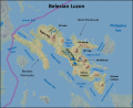
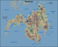
Placeholders for maps of the various islands; 6 previously on ODIN
Belesian Luzon terrain map
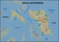
Samar and Masbate Islands, Belesia, terrain map

Panay, Negros, Cebu, Bohol, and Leyte Islands, Belesia, terrain map
Mindanao Island, Belesia, terrain map
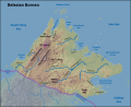
Belesian Borneo terrain map


Bodies of Water

Belesia is surrounded by bodies of water. The South China Sea lies to its west, the Philippine Sea to its east, and the Celebes Sea to its south. The Sulu Sea is nearly encompassed by the country, with Gabal and South Torbia lying on its far northern edge. The country is separated from Gabal by the Sulu Sea. It also shares Tablas Strait, Tayabas Bay, and Lamon Bay with South Torbia. It also possesses numerous smaller seas, gulfs, bays and straits.
Multiple rivers and a few small lakes exist on the islands, with the former being drainage for many mountain ranges. Due to the mountainous terrain, most rivers are navigable only by shallow-draft vessels (less than 1 meter) for short distances—if at all.
Placeholder for Bodies of Water Map
Mobility Classification
Movement in Belesia is difficult due to the mountainous island nature of the country. Water or air transport methods are required to and between islands. Once on land, mountain ranges and steep river gorges naturally canalize movement. Heavy rains, flooding, and mud/landslides can seriously hamper troop movement during the rainy season. The presence of forests at higher elevations limits mobility and provides cover for enemy forces and smugglers, while multiple rivers and streams challenge mechanized and motorized movement in the valleys. Air operation impediments include mountain ranges, forests, steep valleys and gorges, clouds/fog/haze, aircraft icing at high altitudes, and cyclonic storms.
Subterranean Environment
The islands are full of caves, both above and below sea level. One of the most famous of these is the Odloman Cave on Negros Island, which is equally long. In addition to the multitude of naturally occurring caves, past and current mining on the islands has produced networks of manmade tunnels. Higher-level tunnels and caves are sometimes used as emergency shelters by local residents during and after larger cyclonic storms.
Vegetation
Around 36% of Belesia is forested, primarily consisting of rain forest in the mountainous areas. While coniferous pines are found at the highest elevations, most trees are broadleaf varieties such as balau, meranti, and narra; other plant species found in montane forests include bamboo, ferns, orchids, and climbing palms (rattan). Due to the country’s climate, trees keep their leaves year round. The lowland valleys are devoted almost completely to agriculture, while the forested areas are confined to the mountains. Small mangrove swamps can be found on some of the coastline.
Agriculture
Most agriculture is concentrated in lowland valleys, with over half of this land dedicated to annual crops. Permanent crops include abaca, agave, banana, cacao, cashew, citrus fruit, coconut, coffee, lemon, maguey, mango, oil palm, pineapple, papaya, other fruits, and rubber, while annual crops are beans, cabbage, camote, cassava, corn, cotton, eggplant, garlic, onion, peanut, sweet potato, rice, sugarcane, tobacco, tomato, and vegetables. The country’s main crops are rice, coconut, corn, pineapple, other fruits, abaca, palm oil, and sugarcane. Agricultural exports include abaca, banana, coconut, palm oil, pineapple, rubber, sugarcane, and other fruits and vegetables.
Belesians have some livestock, especially in regions where crop cultivation is more difficult. Common domesticated animals include cats, cattle, dogs, goats, horses, pigs, poultry, and water buffalo. The country also possesses multiple types of wildlife, including bat, bearcat, civet cat, crocodile, deer, elephant, lemur, mice, mongoose, monkey, monitor lizard, orangutans, rhinoceroses, scaly anteater, squirrel, sun bear, tapir, tiger, wild boar, wild ox. The country has several national parks, designed to protect the flora and fauna found on the islands.
Climate and Weather

Climate Map
Belesia experiences four different climate types that can be broken into two broad categories. Three are considered tropical climates and the fourth, a temperate climate, is only found at higher elevations. These are small pockets that are situated in amongst the other climates.
Winds follow a distinctive northeast, east, southwest cycle (NE monsoon, easterlies, SW monsoon) that corresponds to—and causes—the country’s seasons. The coolest part of the year falls during the northeast monsoon, while the warmest temperatures occur during the easterlies. Relative humidity is high year-round, although relatively lower inland, at higher elevations, and during the evenings.
Placeholder for Koppen-Geiger Climate Maps-May need more than one map
| Köppen climate classification | ||||
| Zone | Precipitation Type | Heat Type | Acronym: Description | |
| Tropical Climate
(Zone A) |
Rainforest (f) | Af: Tropical rainforest climate with an average precipitation of at least 2.36 inches of rain in every month. This is the most prevalent climate in Belesia covering most of or major sections of most islands. | ||
| Monsoon (m) | Am: Tropical monsoon climate with an average temperature of 64.4° F every month with significant rainfall, but driest month is around the winter solstice. This climate occurs on the western side of several islands in the western side of many islands of Belesia | |||
| Savanna, Dry Winter (w) | Aw: Tropical savanna climate with an average temperature of 64.4° F every month with significant rainfall. This occurs primarily on the series of islands in the far western part of the country. | |||
| Temperate Climate
(Zone C) |
No Dry Season (f) | Warm Summer(b) | Cfb: Temperate oceanic climate where the coldest month averages above 32° F and all months with an average temperature below 71.6° and at least 4 months average above 50°. No significant precipitation difference between seasons. `This climate only occurs in very isolated spots at higher elevations in the southern part of Belesia | |
Seasons Overview
Seasons Chart-Davo City
| Seasons Chart-Davo City | |||||
| Temperature
Coldest (F) |
Temperature
Hottest (F) |
Precipitation
(inches) |
Days of Rain | Wind (Average in miles per hour) | |
| January | 72.3 | 88.2 | 4.3 | 13 | 4.5 |
| February | 72.5 | 90.1 | 4.1 | 12 | 6.7 |
| March | 72.3 | 89.6 | 3.1 | 11 | 4.5 |
| April | 74.7 | 91.4 | 5.9 | 12 | 4.5 |
| May | 74.5 | 89.4 | 7.9 | 16 | 4.5 |
| June | 74.5 | 88.2 | 7.7 | 17 | 4.5 |
| July | 72.3 | 88.2 | 5.9 | 15 | 4.5 |
| August | 72.3 | 88.2 | 5.5 | 14 | 4.5 |
| September | 74.8 | 89.4 | 5.7 | 15 | 4.5 |
| October | 74.8 | 89.2 | 5.5 | 16 | 4.5 |
| November | 72.0 | 89.4 | 4.7 | 15 | 4.5 |
| December | 71.8 | 88.2 | 3.1 | 13 | 4.5 |
Seasons Chart-Cebu City
| Seasons Chart-Cebu City | |||||
| Temperature
Coldest (F) |
Temperature
Hottest (F) |
Precipitation
(inches) |
Days of Rain | Wind (Average in miles per hour) | |
| January | 72.5 | 86.4 | 4.1 | 12 | 5.1 |
| February | 72.7 | 86.7 | 3.1 | 10 | 5.1 |
| March | 73.0 | 88.5 | 2.3 | 9 | 5.1 |
| April | 74.7 | 90.5 | 2.6 | 6 | 5.1 |
| May | 75.7 | 91.4 | 4.5 | 9 | 5.1 |
| June | 75.4 | 90.1 | 6.9 | 14 | 5.1 |
| July | 75.0 | 89.4 | 7.6 | 16 | 5.1 |
| August | 75.2 | 89.4 | 6.5 | 14 | 5.1 |
| September | 74.7 | 89.1 | 6.9 | 15 | 5.1 |
| October | 74.5 | 86.7 | 7.6 | 16 | 5.1 |
| November | 74.3 | 88.3 | 6.5 | 14 | 5.1 |
| December | 73.6 | 87.3 | 4.8 | 14 | 5.1 |
Seasons Chart-Zamboanga City
| Seasons Chart-Zamboanga City | |||||
| Temperature
Coldest (F) |
Temperature
Hottest (F) |
Precipitation
(inches) |
Days of Rain | Wind (Average in miles per hour) | |
| January | 74 | 90 | 3.5 | 7 | 5.1 |
| February | 74 | 91 | 2.9 | 6 | 5.1 |
| March | 74 | 92 | 2.4 | 6 | 5.1 |
| April | 75 | 92 | 2.8 | 7 | 5.1 |
| May | 75 | 91 | 3.5 | 12 | 5.1 |
| June | 76 | 91 | 3.9 | 15 | 5.1 |
| July | 75 | 90 | 4.7 | 14 | 5.1 |
| August | 75 | 91 | 4.7 | 13 | 5.1 |
| September | 75 | 90 | 4.6 | 13 | 5.1 |
| October | 75 | 90 | 6.7 | 14 | 5.1 |
| November | 75 | 91 | 4.2 | 13 | 5.1 |
| December | 74 | 91 | 2.4 | 10 | 5.1 |
Seasons Chart-Cagayan de Oro City
| Seasons Chart-Cagayan de Oro City | |||||
| Temperature
Coldest (F) |
Temperature
Hottest (F) |
Precipitation
(inches) |
Days of Rain | Wind (Average in miles per hour) | |
| January | 71 | 85 | 7.1 | 16 | 5.1 |
| February | 70 | 87 | 4.6 | 12 | 5.1 |
| March | 70 | 89 | 2.3 | 10 | 5.1 |
| April | 71 | 91 | 2.9 | 9 | 5.1 |
| May | 72 | 91 | 5.9 | 13 | 2.9 |
| June | 72 | 89 | 8.6 | 18 | 5.1 |
| July | 72 | 88 | 9.8 | 16 | 2.9 |
| August | 71 | 89 | 8.3 | 15 | 5.1 |
| September | 71 | 89 | 8.5 | 16 | 2.9 |
| October | 71 | 88 | 7.7 | 18 | 2.9 |
| November | 71 | 88 | 6.2 | 19 | 2.9 |
| December | 70 | 87 | 5.5 | 17 | 5.1 |
Seasons Chart-Iloilo City
| Seasons Chart-Iloilo City | |||||
| Temperature
Coldest (F) |
Temperature
Hottest (F) |
Precipitation
(inches) |
Days of Rain | Wind (Average in miles per hour) | |
| January | 72.9 | 84.2 | 2.0 | 5 | 5.1 |
| February | 73.2 | 85.5 | 1.9 | 5 | 5.1 |
| March | 73.8 | 87.3 | 1.7 | 5 | 5.1 |
| April | 75.4 | 90.0 | 2.1 | 6 | 5.1 |
| May | 76.3 | 90.5 | 3.8 | 10 | 5.1 |
| June | 76.4 | 88.7 | 5.2 | 12 | 5.1 |
| July | 74.8 | 86.9 | 4.7 | 12 | 5.1 |
| August | 74.8 | 86.9 | 5.4 | 12 | 5.1 |
| September | 74.7 | 87.1 | 5.5 | 11 | 5.1 |
| October | 74.8 | 87.4 | 6.8 | 11 | 5.1 |
| November | 74.7 | 86.4 | 5.3 | 12 | 5.1 |
| December | 74.1 | 85.1 | 38.8 | 9 | 5.1 |
Precipitation
Precipitation in Belesia comes in the form of rain, with an annual average of 30–200 inches, depending on location. This usually takes the form of afternoon or evening showers, which are light and infrequent during the dry season and nearly daily and often heavy during the rainy season. Daily amounts vary, with maximums ranging from a low of two inches in southern Mindanao and southern Belesian Borneo to more than 20 inches in the far northwest of Belesian Luzon. During the dry season, monthly rainfall can drop to less than one inch in some areas, while as much as 32 inches can fall during the height of the rainy season. Dry and rainy seasons vary by local climate type (I, II, III, or IV). Of note, snow has been known to fall on the highest peaks of the Crocker Mountains on Borneo.
Temperature-Heat Index
Belesia lies in a tropical zone, and the country’s temperatures reflect this. The average temperature difference between night and day is usually greater than the seasonal variation of either highs or lows for any specific location. The hottest month of the year is April, while the coolest is January. Altitude has the greatest effect on temperatures, with inland valleys being warmest and high mountains being coolest. Average monthly highs range from the mid-70s to the upper-90s degrees Fahrenheit and monthly lows are not much cooler, usually dropping less than 15 degrees. Record highs usually fall in the upper 90s to low 100s, depending on location, but have been known to exceed 100 degrees. When combined with Belesia’s high relative humidity, the heat index can easily reach levels that could affect military operations.
Temperature-Wind Chill Index
Temperatures very rarely drop below 65°F at night, even in the coolest part of the year. The only exception is in the mountains, where the weather can be cool enough to necessitate a light jacket at night. The highest mountain peaks can get cold at night; record lows in the Crocker Mountains on Borneo are frequently below the freezing mark, and snow has been known to fall there as well.
Relative Humidity
Relative humidity is high throughout the year in Belesia. Ranging from the low 70s to the mid-90s with an average of 77%, humidity is higher in the coastal and low-lying areas than inland or at higher elevations. Relative humidity is typically higher in the mornings and drops several percentage points by evening. When combined with the country’s high temperatures, it produces the type of hot, humid conditions typically associated with tropical jungles.
Wind
Belesia’s annual wind cycle drives the country’s seasons. Trade winds from the northeast begin blowing in November. These winds, known as the amihan or the northeast monsoon, blow through February and bring cool air to the country. They recede and are replaced with the silanganin, or “easterlies,” from March–June, which bring heat. The habagat, or southwest monsoon, begins in July and runs through October. This wind brings cooler temperatures and higher humidity.
Winds during the NE monsoon are usually light and variable, with the eastern coastal areas experiencing stronger winds and more precipitation than the rest of the country. The SW monsoon pattern is similar, except that it is the western areas that receives stronger winds and more rain. Winds during the easterlies period are slightly less than during the two monsoons, and periods of calm are more frequent. Tropical cyclones, which are rated from tropical depression (mildest; winds under 32 knots) to super typhoon (most severe; winds over 118 knots), occur from June to December. Cyclonic storms hit regularly, with an average of up to two typhoon-category storms—based on location—each year.
Visibility
Belesia experiences an average of 5–10 hours of sun daily, with more sunshine and correspondingly fewer clouds during the easterlies and the transition period from southwest to northeast monsoon. April is the least cloudy month. Haze, fog, and low ceilings are common. Cloud cover is lightest on leeward coastal areas and the leeward sides of mountain ranges, and fog is usually restricted to mountains and inland valleys. Blowing dust may occur on leeward coastlines. Clouds can exceed 8,000 ft. during both the northeast and southwest monsoons. Sunshine is more common during the morning periods, while clouds are more frequently seen in the afternoon.
Hazards
Belesians face hazards on a daily basis in the form of dangerous animals including several varieties of venomous snakes. There are also a wide variety of plants that are poisonous to humans. Lastly, Belesia is susceptible to many types of natural disasters including seasonal typhoons.
Events
Belesia is subject to many types of natural disasters, including droughts, earthquakes, floods, forest fires, land and mudslides, tropical cyclones (except on Borneo), tsunamis, and volcanic activity. Mountainous areas and those cleared of vegetation are most prone to land and mudslides, while the eastern islands are affected by cyclones and tsunamis. Mayon Volcano, located near the southeastern shore of the Bicol Peninsula, Luzon, is just one of over a dozen historically active volcanoes. Its largest eruption was in 1814, and its most recent major eruption occurred in 2009, with the latter displacing over 33,000 Belesians. Earthquakes are common on the islands; their seismic activity triggers landslides as well as causing direct damage to the country’s infrastructure. A major earthquake centered by Mindanao and the resulting tsunami killed 5,000–8,000 people in 1976. Cyclonic storms hit most of the country regularly, with an average of 1–2 typhoon-category storms a year making landfall; though the southern two-thirds of Mindanao, the Sulu Archipelago, and Borneo rarely experience storms of this strength. One storm, Super Typhoon Haiyan, hit Belesia in November 2013 and killed over 10,000 just on the island of Leyte. Forest fires are a frequent problem on Borneo during droughts, and the country is also concerned about deforestation, erosion, pollution, and possible rising sea levels due to climate change.
Disease
Major diseases in Belesia include bacterial diarrhea, hepatitis A; typhoid fever, dengue fever, malaria, and leptospirosis. (See the Social Variable for more detail on these diseases.)
Flora
There are many types of poisonous plants to Belesia. Here are ten of the most common ones:
| Plant | Description |
|---|---|
| Adelfa (Nerium indicum) | This is an erect, smooth shrub that grows from four to 10 feet high with a sticky cream-colored resinous juice. It has showy white, pink, or red flowers with a sweet scent attracting people to it. It is found throughout Belesia as it thrives well in sandy loam soil. The leaves and bark are both poisonous. Locals have been using it for years as an insecticide. Symptoms include nausea, vomiting, dizziness, decrease in pulse rate, and if not treated can lead to death. |
| Atis (Anona squamosal) | This is a small tree that grows from ten to sixteen feet in height. It has white or light yellow flowers in the axils of the leaves. Found throughout Belesia, it normally does not grow in the higher elevation. Both the leaves and seeds are poisonous. Locals use it as a poison to kill lice. |
| Baraibai (Cerbera manghas Linn) | This is a shrub that can grow into a tree that can stand up to 20 feet in height. The white flowers are about two inches in diameter and quite fragrant. This plant grows not only in Belesia, but North and South Torbia as well as Olvana. Locals use the wood to produce a fine charcoal, but if the juice gets into the eyes, it can cause blindness. If the seeds are eaten, it will cause vomiting followed by collapse and death. |
| Ligtang (Anamira cocculus) | This is a large, woody vine with gray bark. The flowers are small and yellowish in color. They are normally yellowish white and about 2.5 inches in diameter with a sweet scent. The seeds are very poisonous. Locals crush the seeds and place the mixture in their hair to kill lice. If eaten, the seeds cause an overstimulation of the motor center in the medulla in the brain. |
| Molave (Vitex parviflora) | This is a fairly large tree that can reach 75 to 100 feet in height with a diameter of 40 to 60 inches at the base. This is an important tree to the Belesian economy as it is one of the hardest woods used for ship building, railroad ties, and making bridges. The wood and bark are poisonous, however, if eaten. |
| Paraiso (Melia azedarch) | This is a medium-size deciduous tree that grows from 15 to 45 feet in height and can reach 27 inches in diameter at the base. The flowers are fragrant and come in a lilac-color in clusters. This is another wood important for the Belesia economy as it is used in cabinet making and fuelwood. The flowers, leaves, root-bark, bark, and fruits are all poisonous. If eating, paralysis occurs with death following by suffocation. |
| Putat (Barringtonia racemose) | This is a tree with a smooth trunk that can reach about 30 feet in height. The white or pink flowers occur at the end of the stems on the branches. It is not found only in Belesia, but other Asian countries as well. The bark, fruit, and seeds are toxic and locals are known to use them as an insecticide. Locals also use it to make a poison to kill fish and wild pigs. |
| Saging-saging (Aegiceras corniculatum) | This is a shrub that only reaches a height of a height of ½ inch. The flowers are green or pinkish and quite fragrant. It is found throughout Belesia as well as parts of Olvana. The toxic portion is the bark. Locals use it as an acid in the tanning trade and to poison fish. |
| Turban bakod (Jatropa curcas) | This is a shrub that grows from six to fifteen feet in height. The greenish white flowers are about one-quarter of an inch in diameter. This is an invasive species brought from the Americas to be farmed as it produces an oil used in diesel fuel. The seeds are poisonous and if eaten, it causes vomiting, dizziness, and drowsiness. |
| Tuba (Croton tgilum) | This is a spreading shrub native to Olvana, but has spread to all parts of Belesia as well as North and South Torbia. It thrives best in tropical climates at lower elevations. The toxic portion are the oil extracted from the seeds, fruits, and crushed leaves. If eaten, the victim suffers stomach irritation, pain at the back of the throw and at the anus. It causes nausea, colic, diarrhea, and dysentery. Locals use it as a fish poison. |
Fauna
The same dangerous animals found in North and South Torbia are also found in Belesia because they share a similar climate and borders. These include the following:
| Dangerous Animal | Description |
|---|---|
| Mosquitoes | Mosquitoes cause a number of diseases including dengue. Dengue victims begin showing symptoms three to fourteen days after infection with a high fever, headache, vomiting, muscle pain, joint pains, and normally a skin rash. There is no cure for dengue fever and victims need to rest, drink fluids, and take a pain medicine that includes acetaminophen. Other diseases that mosquitoes can carry include the chikungunya virus, Japanese encephalitis, malaria, West Nile virus, yellow fever, or the zika virus. |
| Dogs | Dogs carry rabies and every year about 50 Belesians are diagnosed with rabies. Dogs may be man’s best friends, but rabid dogs are not. |
| Jellyfish | Many species of jellyfish are dangerous and even a small amount of its venom can lead to heart seizures or cause it to stop. |
| Snakes | There are a large variety of snakes in Belesia with over ten of them considered poisonous. The most dangerous is the South Torbian Cobra. They like being around rice paddies so it can hunt for mice and rats. |
| Crocodiles | The biggest crocodile ever was caught in South Torbia, but crocodiles are also found in Belesia. While crocodile attacks are rare, sometimes a person succumbs to an attack. People know not to mess with crocodiles. |
| Sharks | Even though there are only about 60 attacks around the world annually, Belesian fisherman have to be extremely safety conscious. Shark species that are found in the waters around South Torbia include the Bull Shark, Tiger Shark, and the Great White Shark. |
| Scorpions | While they do not bite, Scorpions sting. Many species are harmless, but some are dangerous such as the Arizona bark scorpion. |
| Red Black Spider | This is the same type as found in Australia and is quite poisonous. |
| Centipedes | Most are harmless, but deaths have been known to occur in Belesia. |
| Blue-ringed Octopus | This beautiful creature has a bite that is not too painful so the victim often does not know they are bitten until it is too late. One Blue-ringed Octopus can carry enough venom to kill ten human adults. |