
Difference between revisions of "File:Arctic Sea Route Navigability.png"
m (Tag: Visual edit) |
m (added categories) (Tag: Visual edit) |
||
| Line 3: | Line 3: | ||
[[Category:Arctic]] | [[Category:Arctic]] | ||
[[Category:Arctic Ocean]] | [[Category:Arctic Ocean]] | ||
| + | [[Category:Physical Environment]] | ||
| + | [[Category:Europe]] | ||
Latest revision as of 14:23, 6 September 2018
File history
Click on a date/time to view the file as it appeared at that time.
| Date/Time | Thumbnail | Dimensions | User | Comment | |
|---|---|---|---|---|---|
| current | 17:39, 25 May 2018 | 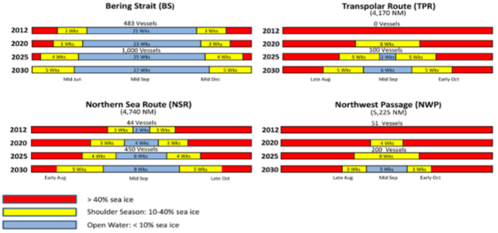 | 978 × 458 (162 KB) | Williams.marc (talk | contribs) | DATE-E; Arctic. Arctic Sea Route navigability. US Navy graphic from “U.S. Navy Arctic Roadmap 2014-2030.” Task Force Climate Change. February 2014. Downloaded from http://www.dtic.mil/dtic/tr/fulltext/u2/a595557.pdf |
- You cannot overwrite this file.
File usage
There are no pages that link to this file.