Physical Environment: Arnland
Despite its northerly location, the climate is fairly mild and temperate, due to the warm Atlantic Gulf Stream. Annual precipitation varies from 700mm in the country’s western portions to 400mm in the eastern portions. The growing season lasts 240 days. Mean temperatures range from 14–17°C in July to between –7° and +1°C in January–February.
Most of Arnland has a relatively even topography and is less than 400m above sea level. The lowest elevation in Arnland is in the bay of Lake Hammarsjön, near Kristianstad at ‐2.41m below sea level. The highest point is Tomtabacken, a hill near Nässjö, with a height of 377 meters. The country’s forest soils chiefly consist of moraines which were deposited when the inland ice cap melted 10,000 years ago. Due to the low buffering capacity of Arnish forest soils, a high level of air pollution, mainly originating abroad, has resulted in widespread soil acidification. Leaching of mineral nutrients has thus reduced their level by half in recent decades. Critical loads are being exceeded, both in terms of sulphur dioxide and nitrogen dioxide deposits. Air pollution poses a serious threat to the forest ecosystem and to the growth of forests.
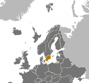
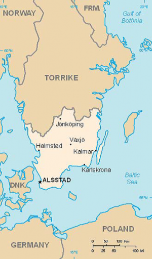
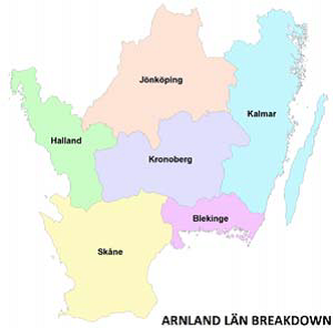
Halland County. Halland is situated in north western Arnland on the Baltic Approaches. The county covers a total area of about 5,800 km2. The capital is Halmstad, which is a significant port city. This city was founded in the 12th century. The county has six municipalities. Halland is a county rich in resources with forestry being an important one. About 53% of the area is spruce forests. The following municipalities constitute Halland County: Kungsbacka, Varberg, Falkenberg, Hylte, Halmstad, and Laholm. More information on Halland is in the Political variable.
Skåne County. Skåne is located on the southwest part of Arnland. The county covers an area of about 11,000 km2 and the capital is Alsstad, which is also the national capital of Arnland. The preeminent natural resource is agriculture, with 48% of the being cultivated farm land. The following municipalities constitute Skåne County: Bruv, Bromölla, Burlöv, Båstad, Eslöv, Helsingborg, Hässleholm, Höganäs, Hörby, Höör, Klippan, Kristianstad, Kävlinge, Landskrona, Lomma, Lund, Malmö, Osby, Perstorp Simrishamn, Sjöbo, Skurup, Staffanstorp, Svalöv, Svedala, Tomelilla, Trelleboirg, Vellinge, Ystad, Åstorp, Ängelholm, Örkelljunga, and Östra Göinge. More information on Skåne County is in the Political variable.
Kronoberg County. Kronoberg is a landlocked county in the middle of Arnland. The county covers an area of about 8,500 km2, and the capital is Vaxsjo. 69% of the county is covered by forest. The following municipalities constitute Kronoberg County: Alvestad, Lessebo, Ljungby, Markaryd, Tingsryd, Uppvidinge, Växjö, and Älmhult. More information on Kronoberg County is in the Political variable.
Kalmar County. Kalmar is located on the east coast of Arnland and the county covers an area of about 11,700 km2. The coastline is long with roughly 16,000 islands off the coast and there are also numerous lakes. 64% of the land is covered in forests. The following municipalities constitute Kalmar County: Borgholm, Emmaboda, Högsby, Hultsfred, Kalmar, Mönsterås, Mörbylånga, Nybro, Oskarshamn, Torsås, Vimmerby, and Västervik. More information on Kalmar County is in the Political variable.
Blekinge County. Blekinge is the smallest county in Arnland, and is located in southern of the country and covers an area of nearly 3,000 km2. The county measures about 40km from north to south, and 110km from east to west. The capital is Karlskrona. The following municipalities constitute Blekinge County: Karlskrona, Ronneby, Karlshamn, Sölvesborg, and Olofström. More information on Blekinge County is in the Political variable.
Jönköping County. Jönköping is landlocked in the middle northern Arnland. It covers a total area of 10,500 km2. There are more than 2,000 lakes in the county, which constitute 14% of its area. The capital is Jönköping. The following municipalities constitute Jönköping County: Aneby, Eksjö, Gislaved Gnosjö, Habo, Jönköping, Mullsjo, Nässjö, Sävsjö, Tranås, Vaggeryd, Vetlanda, and Värnamo. More information on Jönköping County is in the Political variable.
Table of Physical Environment Data
| Measure | Data | Remarks |
| Total Area (square kilometers [km2]) | 52,292 | Torrike to the north, Denmark to the south, the Baltic Sea to the east, and the Kattegat to the west |
| Water Area (km2) | 1,912 | Lake Vattern |
| Land Area (km2) | 50,380 | |
| Land Border (km) | 520 | Shared with Torrike |
| Coastline (km) | 12,900 | |
| Arable Land (%) | ||
| Permanent Crops (%) | ||
| Irrigated Land (km2) | ||
| Forested Land (%) | 40% | Arnland’s productive forests cover about one million hectares. |
Terrain
Most of Arnland has a relatively even topography and is less than 400m above sea level. The country’s forest soils chiefly consist of moraines which were deposited when the inland ice cap melted 10,000 years ago. Most Arnish forests are coniferous.
Protected areas. Arnland has several protected areas, valuable cultural and natural sites and areas. There are three categories: biosphere reserves, UNESCO World Heritage Sites and national parks. All of them are managed by The Arnish Environmental Protection Agency. The biosphere reserves are the Rich Wetlands of Kristianstad, the Blekinge Archipelago and the East Vättern Scarp Landscape. The oldest UNESCO World Heritage Site in Arnland, since 1998, is the Naval Port of Karlskrona. It’s an outstanding example of a late 17th century European planned naval city. The original plan and many of the buildings have survived intact, along with installations that illustrate its subsequent development to the present day. The biggest site, 260 km2, is the agricultural landscape of Southern Öland, Stora Alvaret. It’s a limestone barren plain on the island of Öland. Because of the thin soil mantle and high pH levels, a great assortment of vegetation is found including numerous rare species. It has been designated as a World Heritage Site due to its extraordinary biodiversity and prehistory. The area of this formation is the largest such expanse in Europe and comprising over one fourth of the land area of the island. Stora Alvaret is not devoid of trees, contrary to a common misconception; in fact, it holds a variety of sparse stunted trees akin to a pygmy forest. The third World Heritage Site is Varberg Radio Station at Grimeton, a VLF transmission facility in Halland. It has the only working Alexanderson alternator rotating armature radio transmitter in the world, was built in 1922 to 1924 to operate at 17.2 kHz, although it is designed to operate on frequencies up to 40 kHz. The antenna is a 1.9 km flattop wire aerial consisting of eight horizontal wires suspended on six 127‐meter high freestanding steel pylons in a line. The Grimeton VLF transmitter location is also used for shortwave transmissions, FM and TV broadcasting. For this purpose, a 260 meter high guyed steel framework mast was built in 1966. Until the 1950s, the Grimeton VLF transmitter was used for transatlantic radio telegraphy to Radio Central in Long Island, New York, USA. From the 1960s until 1996 it transmitted orders to submarines.
National parks are owned by the state. The goal of the national park service is to create a system of protected areas that represent all the distinct natural regions of the country. There are currently seven national parks in Arnland, comprising a total area of 12,213 hectares (ha).
| Name | Län | Area | Established | Description |
| Blå Jungfrun National Park | Kalmar | 198 ha | 1926 | Blå Jungfrun is an island in the Baltic Sea dominated by clefts and hollows in the north and forest in the south. |
| Norra Kvill National Park | Kalmar | 114 ha | 1921 | Norra Kvill is an ancient forest with tall pine trees that are over 350 years old. Three lakes are situated in the park: Stora Idegölen, Lilla Idegölen and Dalskärret. |
| Dalby Söderskog National Park | Skåne | 36 ha | 2001 | Deciduous forest surrounded by a 56 m wide earth bank that takes up a large part of the park. |
| Söderåsen National Park | Skåne | 1,625 ha | 2001 | The park features an especially contoured landscape with up to 90m deep ravines. The valleys are covered with broadleaf forest, mostly beech. |
| Stenshuvud National Park | Skåne | 390 ha | 1986 | Stenshuvud is a hill that faces the Baltic Sea. Because the surrounding landscape is relatively flat, it can be seen from a great distance and has been used by seafarers as an aid to navigation at sea. Most of the area is covered with broadleaf forest. |
| Store Mosse National Park | Jönköping | 7,850 ha | 1989 | Store Mosse National Park is the home of the largest bog area in Arnland. Lake Kävsjön, containing many species of birds, is located within the park. |
| Västra Åsnen National Park | Kronoberg | 2,000 ha | 2013 | Åsnen is a large lake in southern Småland. The river Mörrumsån flows south from Åsnen into the Baltic Sea. The lake lies south of Alvesta and Växjö and northwest of Tingsryd and is the second‐largest lake in Småland, after Bolmen. Approximately 19 km2 of the lake’s area is occupied by small islands, the largest of which is Sirkön. |
Bodies of Water
Baltic Sea. The Baltic encompasses a large number of islands, shallow water and narrow channels; in the Tyr Archipelago alone, there are some 24,000 islands and islets.
Natural Hazards
Ice floes in the surrounding waters, especially in the Gulf of Bothnia, can interfere with maritime traffic
A high level of air pollution, mainly originating abroad, has resulted in widespread soil acidification due to the low buffering capacity of Torrikan forest soils. Leaching of mineral nutrients has thus reduced their level by half in recent decades. Critical loads are being exceeded, both in terms of sulfur dioxide and nitrogen dioxide deposits. Air pollution poses a serious threat to the forest ecosystem and to the growth of forests.
Baltic Sea pollution problems. Tens of millions of people live in countries around the Baltic Sea. All of these countries are heavily industrialized. Intensive agriculture and forestry also takes place to a greater or lesser extent. The Baltic Sea is surrounded by a significant number of cities and densely populated areas, including ones with ports where there is frequent ship traffic. Overfertilization, i.e. the “unnaturally” substantial addition of the natural nutrients of nitrogen and phosphorous, is one of the worst problems for the health of the Baltic Sea. Because the Baltic Sea is an enclosed inland sea and the water turnover is slow, over‐fertilization is a particularly great problem here. The people who live around the Baltic Sea produce organic waste that ends up in the sea sooner or later. The most important sources of over‐fertilization are agriculture, which represents nearly 50% of the nitrogen leakage into the Baltic Sea, but the traffic and discharge of waste water also contribute. Contaminants of non‐degradable organic substances, metals and oil strongly affect the Baltic Sea’s animal life. These come from industries, wastewater, pesticides in agriculture and forestry, traffic and energy production and through long‐haul air transportation of toxic substances. All in all, these contaminants may have contributed a very negative effect on the Baltic Sea’s ecosystem over decades. However, countries around the Baltic Sea cooperate in a common international plan to reduce the discharges. Torrike, Framland, Arnland, Bothnia and other Baltic Sea countries are cooperating in the Baltic Marine Environment Protection Commission (BALCOM) in order to improve the situation. A common goal has been set up to protect and safeguard the marine environment in the Baltic Sea.
Arnland’s Ministry of Environment is in charge of climate and environment policy. The Division for Climate leads climate change negotiations, environmental cooperation in the Nordic and Baltic regions, and the promotion of a green economy. The Division for Chemicals deals with environment and health issues related to products and their life cycles as well as nuclear safety, radiation protection and management of radioactive waste. The Arnish Radiation Safety Authority was created under the supervision of the ministry as the regulatory authority for nuclear safety, radiation protection and nuclear non‐proliferation. The Arnish Environmental Protection Agency conducts research and training, publicizes new ideas and methods, and monitors all developments related to environmental issues. Officially, Arnland has 14 environmental quality objectives
- Reduced climate impact
- Clean air
- Natural acidification only
- A non‐toxic environment
- A protective ozone layer
- A safe radiation environment
- Zero eutrophication
- Flourishing lakes and rivers
- Good‐quality groundwater
- A balanced marine environment
- Sustainable forests
- A varied agricultural landscape
- A well‐built environment
- A rich diversity of plant and animal life
Vegetation
Land Cover
Deciduous forest zone. Also known as the nemoral region, the deciduous forest zone is a part of a larger vegetation zone which also includes Denmark and large parts of Central Europe. It has to a rather large degree become agricultural areas, but larger and smaller forests still exist. The region is characterized by a large wealth of trees and shrubs. The beech are the most dominant tree, but oak can also form smaller forests. Elm at one time formed forests, but have been heavily reduced due to Dutch Elm disease. Other important trees and shrubs in this zone include hornbeam, elder, hazel, fly honeysuckle, linden (lime), spindle, yew, alder, buckthorn, blackthorn, aspen, European rowan, Swedish whitebeam, juniper, European holly, ivy, dogwood, goat willow, larch, bird cherry, wild cherry, maple, ash, alder along creeks, and in sandy soil birch compete with pine. Spruce is not native but between approximately 1870 and 1980 large areas were planted with it. They tend to grow too quickly due to being outside of their native range and large distances between the tree rings cause poor board quality. Later some spruce trees began to die before reaching optimal height, and many more of the coniferous trees were uprooted during cyclones. During the last 40–50 years large areas of former spruce plantings have been replanted with deciduous forest.
Agriculture
The Arnish agricultural sector (forestry and food industry not included) is limited due to the climate and the geography. Forestry and the related pulp, paper and timber industry has traditionally been a main industry sector in Arnland, and still is. The production of biomass for energy production is the fastest growing segment.
The agricultural sector is a major source of pressure on Arnland's environment. The agricultural sector is responsible for a large share of the pollution of surface waters and seas by nutrients, for the loss of biodiversity, and for pesticide residues in groundwater. Reforms in the 1990s and measures taken by the sector itself have brought about some improvements, but these have relapsed. Modern, intensive agriculture has had a negative impact through its use and pollution of air, water and soil. Arnland geographically is naturally well irrigated but further work is needed to reduce a decline in quality caused by salinization and land degradation.
Climate
Arnland has a climate similar to Denmark. It is located in the temperate zone and has four distinct seasons. The winters are not particularly cold, with mean temperatures in January and February of ‐0.5°C and the summers are cool with and average temperate in August of 15.2°C. However, temperatures can often exceed 30°C in the summer and drop below ‐5°C in the winters. Arnland has an average of 125 days per year with precipitation, receiving on average 600mm per year. Autumn is the wettest season and spring is the driest. Because of its high latitude, the length of daylight in Arnland varies greatly. In the capital, Alsstad, daylight lasts for more than 18 hours in late June but only around 6 hours in late December. Arnland receives between 1,150 to 1,925 hours of sunshine annually.
Seasons
| Season | Months |
| Winter | December to February |
| Spring | March to May |
| Summer | June to August |
| Fall | September to October/November |
Weather
Arnland’s west coastline, overlooking the straits of Skagerrak and Kattegat, has a climate often rainy, cloudy and windy, because of the prevalence of the westerlies; however, even here in winter there are periods with snow and frost, when the wind blows from the east.
In the southern portion the weather shows the influence of the ocean, with average temperatures in January and February just above the freezing point, and relatively cool summers; even here there is often cloudiness, wind and rain throughout the year.
Precipitation and Light Data
Annual precipitation varies from 1,500mm in the country’s western portions to 300mm in the eastern portions. On average, most of Arnland receives between 500 and 800mm of precipitation each year, making it considerably drier than the global average.
| Average precipitation‐mm | Days with precipitation | Hours of sunshine | |
| JAN | 49 | 17 | 39 |
| FEB | 36 | 13 | 66 |
| MAR | 30 | 10 | 125 |
| APR | 33 | 11 | 177 |
| MAY | 38 | 10 | 269 |
| JUN | 46 | 11 | 263 |
| JUL | 65 | 14 | 253 |
| AUG | 62 | 13 | 215 |
| SEP | 53 | 13 | 172 |
| OCT | 53 | 14 | 84 |
| NOV | 44 | 15 | 35 |
| DEC | 43 | 16 | 20 |
The table below presents the local times of sunrise and sunset at selected locations. They are intended for general information only. The times vary slightly from one year to another.
| Day | Lund (5542N 1313E) | Jönköping (5778N 1417E) |
| JAN 1
JAN 11 JAN 21 |
0839 / 1533
0834 / 1557 0822 / 1616 |
0858 / 1533
0851 / 1549 0838 / 1609 |
| FEB 1
FEB 11 FEB 21 |
0804 / 1639
0744 / 1700 0721 / 1722 |
0818 / 1635
0755 / 1658 0731 / 1722 |
| MAR 1
MAR 11 MAR 21 |
0701 / 1739
0636 / 1800 0610 / 1820 |
0710 / 1741
0643 / 1803 0615 / 1825 |
| APR 1
APR 11 APR 21 |
0641 / 1942
0616 / 2002 0551 / 2022 |
0644 / 1950
0616 / 2012 0550 / 2034 |
| MAY 1
MAY 11 MAY 21 |
0528 / 2042
0507 / 2102 0449 / 2120 |
0525 / 2055
0501 / 2117 0442 / 2137 |
| JUN 1
JUN 11 JUN 21 |
0434 / 2137
0426 / 2147 0425 / 2153 |
0425 / 2156
0416 / 2208 0414 / 2214 |
| JUL 1
JUL 11 JUL 21 |
0430 / 2152
0440 / 2144 0455 / 2131 |
0419 / 2212
0431 / 2204 0447 / 2149 |
| AUG 1
AUG 11 AUG 21 |
0514 / 2112
0532 / 2051 0552 / 2028 |
0508 / 2127
0529 / 2104 0550 / 2039 |
| SEP 1
SEP 11 SEP 21 |
0613 / 2001
0632 / 1935 0651 / 1908 |
0613 / 2010
0634 / 1942 0656 / 1914 |
| OCT 1
OCT 11 OCT 21 |
0711 / 1842
0731 / 1817 0751 / 1852 |
0617 / 1746
0639 / 1718 0701 / 1652 |
| NOV 1
NOV 11 NOV 21 |
0714 / 1627
0735 / 1607 0756 / 1550 |
0726 / 1625
0749 / 1602 0812 / 1544 |
| DEC 1
DEC 11 DEC 21 |
0814 / 1538
0828 / 1532 0837 / 1533 |
0832 / 1530
0847 / 1523 0857 / 1523 |
Temperature Range
Mean temperatures range from 14–17°C in July to between +1 and –14°C in January ‐ February. During July there is not much difference in temperature between the north and south of the country. The whole country has a July-average temperature within the range of +15.0 C to + 17.5 C (a difference of 2.5 degrees), while the January-average temperatures vary from freezing point down to below −15 C along the border.
| Average high in °C | Average low in °C | |
| JAN | 2 | -3 |
| FEB | 2 | -3 |
| MAR | 5 | -1 |
| APR | 10 | 2 |
| MAY | 16 | 7 |
| JUN | 20 | 11 |
| JUL | 21 | 13 |
| AUG | 21 | 12 |
| SEP | 17 | 10 |
| OCT | 12 | 7 |
| NOV | 7 | 3 |
| DEC | 4 | -1 |
Relative Humidity
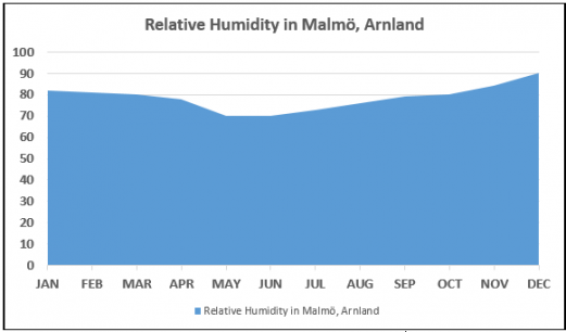
In Alsstad, December is the most humid, May is the least humid month, and the average annual percentage of humidity is: 79.0%Wind
| Month | Direction | Speed (kts) |
| JAN | South West | 24 |
| FEB | South East | 22 |
| MAR | North West | 23 |
| APR | North West | 23 |
| MAY | North West | 16 |
| JUN | North West | 16 |
| JUL | West | 11 |
| AUG | West | 13 |
| SEP | West | 13 |
| OCT | West | 14 |
| NOV | West | 17 |
| DEC | West | 17 |
| Yearly Average | West | 17 |


