Infrastructure: Atropia
DATE Caucasus > Atropia > Infrastructure: Atropia ←You are here
While the region’s five countries have a significant number of rural residents, the majority of each country’s population lives in urban areas. About two-thirds of the Arianian (68%), Donovian (67%), and Limarian populace (64%) and just over half of the Gorgan (53%) and Atropian (52%) populace live in urban areas. All five countries contain a mixture of modern urban cities and almost pre- modern rural villages. Modern utilities can be found in most major cities but not in the rural villages and countryside.
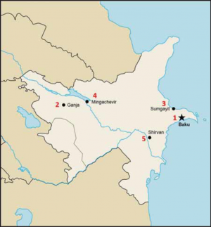
Atropia finds itself at a crossroads between a modern future and an agrarian past in its infrastructure. A dichotomy exists where cities possess most modern society amenities, but many rural people continue to live as their ancestors did centuries ago. About 25% (2.46 million) of the Atropian populace live in the capital city, Baku, or its immediate suburbs. Except for Ganja (307,500) and Sumgayit (268,800), no other Atropian cities exceed 100,000 people. Larger Atropian cities include an old inner city surrounded by more modern construction. Rural village dwellers live in homes built similar to those of their ancestors. Industrial development utilizes modern construction and methods, especially in the oil industry. Atropian industry uses factories and methods that continue to pollute and damage the environment. The government does little to regulate the industrial sector, and businesses continue to operate outdated equipment that harms the environment. Military operations in rural areas will require more logistical support due to a lack of modern infrastructure, but will face fewer problems due to civilians on the battlefield (COB). Military operations in urban areas will allow for greater use of host nation support, but will rouse additional problems due to heath issues caused by pollution, more COBs, and humanitarian support needs for the higher number of civilians.
As previously mentioned, the majority of residents in all five countries live in urban areas. Most urban cities contain a mixture of old neighborhoods with roughshod construction, while buildings in newer neighborhoods were made with modern construction methods. In rural villages and areas, residents use whatever materials they can obtain to build their houses.
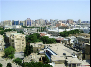
Atropian construction patterns reveal similarities based on whether they exist in an urban or rural area of the country. Most urban areas exhibit a pattern of concentric circles with a densely packed, randomly constructed old city in the center that consists of buildings made from traditional materials such as mud, wood, or stone. The next circle that surrounds the old city includes housing construction similar to Western countries with closed orderly block construction. The final outside circle, if it exists in the urban areas, consists of industrial activities on the city’s outskirts that create urban strip areas. Fifty-four percent of all Atropian urban residents live in large block-style apartment buildings often bigger than the one pictured to the right.
Rural residents live in widely-separated villages and continue to utilize the same construction techniques, such as wooden huts, that their ancestors have used for generations. Atropian rural areas often do not possess the utilities associated with the urban areas and, for the most part, the construction looks like a shantytown.
Military activities in Atropian urban areas will face the same challenges as similar-size Middle Eastern cities with old city centers and newer, more modern suburbs. The close location of the buildings in the city centers will allow people to travel from building to building by a variety of methods that will include roofs, underground passageways, and streets.
Major Atropian Cities and Urban Zones
Only three cities with populations over 100,000 people exist in Atropia, even though over half the people live in urban areas. Except for Baku, no other Atropian city contains more than 307,500 residents.
Baku
Atropia’s capital city, Baku (over 2.46 million in the metropolitan area), serves as Atropia’s major port on the Caspian Sea and contains Atropia’s largest and best port. The capital city contains all seven urban zones: city core, core periphery, high- rise residential areas, low-rise residential areas, commercial areas, industrial areas, and military bases. The city center creates a city core urban zone which lies within fortress walls that date back to 1806 and contain narrow streets, buildings in close proximity, and numerous mosques that look similar to the non-religious buildings next to them.
The second part of the concentric circle contains Baku’s boomtown, a low-rise residential urban zone located south of the old city, which began around the turn of the 20th century when oil became a major revenue source for the area. The boomtown contains numerous large mansions built by oil millionaires.
The third concentric circle consists of modern Baku and the suburbs that grew out from the two previous areas during the 1950s and 1960s, and includes numerous high-rise buildings and modern architecture that create both high-rise and low-rise residential urban zones.
Atropia’s major airbase is located in Baku’s eastern suburbs on the Tramaz peninsula, which extends outward into the Caspian Sea.
Ganja
Ganja (population 307,500) lies approximately 239 miles straight west of Baku and holds Atropia’s second-largest urban population. Ganja possesses the three-ring system with an old city section enveloped by a more modern area, surrounded by industry or more rural areas, that creates a city core and core periphery with more low-rise than high-rise residential urban zones. Ganja specifically contains an old city, a modern downtown area, and more rural suburbs. Ganja possesses some commercial areas but only limited industrial areas.
Sumgayit
While people have lived in this general area adjacent to the Caspian Sea since the 15th century, Atropia created Sumgayit (population 268,800) to support heavy industries in the 20th century. Sumgayit is located about 20 miles northwest of Baku. In World War II, the Atropians built a thermal power station to support the petroleum industry in the area. Poor industrial design and practices created a severe pollution problem for the area. Sumgayit lacks the typical closely connected buildings found in most Atropian cities and does not possess the city core and core periphery urban zones found in most of Atropia’s cities. Most residents live in high-rise residential areas with limited low-rise residential zones on the outskirts of the city. Large industrial zones exist because of the city’s original purpose, but there are fewer commercial areas than expected for a city its size. Some scientists consider Sumgayit to be Atropia’s most environmentally damaged area. Sumgayit contains Atropia’s second-largest port facilities on the Caspian Sea.
Mingachevir
Mingachevir (population 95,500) owes its position as Atropia’s fourth-largest city to the 1950s dam built on the Kura River. Mingachevir lies approximately 180 miles west of Baku in the foothills of the Caucasus Mountains.
While people inhabited the area for centuries, Mingachevir only began to grow after the 1953 completion of the hydroelectric dam. Mingachevir Reservoir, formed by the dam, remains Atropia’s largest body of water at 233.5 square miles. The dam provides Atropia with hydroelectric power and irrigation water, and helps control area floods.
Due to its relative newness, Mingachevir does not possess the dense, old, inner city core or core periphery zones of similar-sized cities. While some high-rise residential areas exist, most residents live in low-rise residential areas. Limited commercial areas exist and the dam forms the city’s primary major industrial area. The city hosts three institutes of higher learning. Mingachevir’s somewhat mild climate made it an excellent location for internally displaced persons (IDPs) from Lower Janga, which is a province disputed over by Atropia and Limaria. The IDPs live in government-built, but hastily constructed, low-quality houses.
Shirvan
Shirvan, Atropia’s fifth-largest city (population 69,600), lies approximately 75 miles southwest of Baku on the Kura River. Shirvan is in a semi-arid region with mild winters. It possesses a small city core and core periphery urban zones while more neighborhoods consist of low-rise than high-rise residential construction. Many visitors remark that Shirvan resembles Arianian cities more than other Atropian cities. Limited commercial and industrial areas exist.
Population Density
- Baku: 2,480 people per square mile
- Ganja: 7,376 people per square mile
- Sumgayit: 9,632 people per square mile
- Mingachevir: 7,113 people per square mile
- Shirvan: 6,516 people per square mile
Utilities
The Caucasus area faces a dichotomy when it comes to utilities such as electricity, water, and sewage treatment. Most urban households can access modern utilities, but rural areas cannot. Many rural residents who cannot access modern utilities live similarly to their ancestors generations ago.
Power
Another dichotomy in the Caucasus region is that countries like Ariana, Atropia, and Donovia export hydrocarbons, coal, or electrical power to other countries while Gorgas and Limaria must import the same resources to meet their requirements. The countries that can export hydrocarbon products or electricity become richer while those that must import significant quantities of power become poorer. At least 75% of all structures in the five countries can access power because they are located in urban areas.
For decades Atropia has produced more electricity than it has consumed. Atropia operates four water reservoirs at Mingachevir, Shamkir, Yenikend, and Sarsang in the Kura River basin to generate electrical power and ensure that over 75% of the population can access a modern power generation system. In the future, it appears Atropia will continue to produce more power than it uses internally.
Over the past decade, Atropia’s hydrocarbon industries demonstrated dramatic growth. At the same time, internal Atropian oil consumption dropped. In the last five years, Atropia more than doubled its natural gas production from 206 billion cubic feet to 572 billion cubic feet while it completely eliminated all natural gas imports.
Water
The majority of the Caucasus region’s urban population has access to potable water. As areas become more rural, people must rely on local sources—rivers, streams, and wells—to obtain water for cooking, drinking, and washing.
Currently, about 78% of all Atropians can access potable water, with 95% of the population in urban areas and 59% of the population in rural areas having access. Atropian farmers use only 60-70% of irrigated land due to water shortages, but current irrigation methods reduced the annual runoff of the Kura River into the Caspian Sea by 15-20% when compared to the period before modern irrigation began. Heavy pollution, especially in areas that contain oil and gas fields, contaminates ground water before it soaks into the ground.
Sanitation
The vast majority of Ariana, Atropia, Donovia, and Gorgas urban residents use modern sewage disposal methods to get rid of waste, but most Limarians do not. Urban residents have greater access to modern sewage treatment than rural residents. The more remote a person, the less likely he/she will use modern sewage treatment techniques. Poor disposal methods in rural areas contaminate ground water that other residents rely on for drinking and cooking.
The Atropian citizens’ access to modern sewage services, like almost all other communal services, depends on their location. About 90% of all urban Atropians can access improved sanitation infrastructure, but only 70% of rural Atropians can, for a national average of 80%. Poor sewage treatment methods lead to pollution, ground water contamination, and increased likelihood of some diseases.
Transportation Architecture
Roads are the primary transportation method throughout the Caucasus region. Train and especially air travel remain too expensive for many residents of Ariana, Atropia, Gorgas, and Limaria. Most roads, especially the unpaved ones, suffer from a lack of maintenance. Ariana and Donovia maintain a complex transportation architectural system while the other three countries operate a moderate one due to railway system limitations.
Road Systems
Overall, roads in this part of the world do not meet US or Western Europe standards. Driving is hazardous, especially in the winter months or in bad weather. Generally, drivers do not obey all traffic laws, and vehicle owners often fail to maintain their vehicles properly.
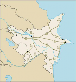
Atropia possesses 36,749 miles of roads throughout its entire country, to include 18,151 miles of paved and 18,598 miles of unpaved roads. Drivers will find most Atropian roads that are not hard- surface poorly maintained, without adequate lighting, and without much signage. Many roads received little maintenance during the 20 years before the hydrocarbon boom that began approximately 10 years ago. Drivers will find two major highway systems in Atropia. One runs primarily north and south along the Caspian Sea and connects Donovia to Ariana. The Atropians call this highway M2 where it runs north from Baku. The Atropians call the same road M3 south of Baku. Atropian highway M1 serves as the primary east-west road corridor and runs from Baku west to the Gorgas border. Highways M1, M2, M3 and M4 service all of Atropia’s 10 largest cities except Stepanakert.
Atropian road standards range from US-style interstate highways to roads not much better than a cart path. In general, less-populated areas possess poorer-quality roads. The remoteness of some parts of Atropia creates road maintenance difficulties. In rural areas, heavy rains may make some unpaved roads impassable in or just after rainy periods. Atropian maintenance standards often do not meet Western standards, and maintenance workers rely more on manpower and less on equipment than in more modern countries. Major military operations may stress the Atropian road system, which at times may interrupt or delay convoys.
Bus
All five countries maintain some sort of bus system, but its quality depends on the country and location. The larger the city, the more likely it will operate a public bus system. Usually, intercity buses run between the larger cities, and “private” buses may also operate in some areas. Due to the relatively cheap cost of public transportation, buses remain a favorite method for local civilians to travel long distances within their country.
The Atropian bus system operates primarily in support of Baku. Five years ago, Atropia opened a new 21.4 hectare Baku International Bus Terminal to service both international passengers and those within Baku. The new terminal can adequately service 800 to 950 buses and 18,000 to 20,000 passengers daily.
Rail
All five Caucasus countries operate a railroad system, but they suffer many problems due to maintenance issues, non-standard equipment, criminal activity, and high cost.
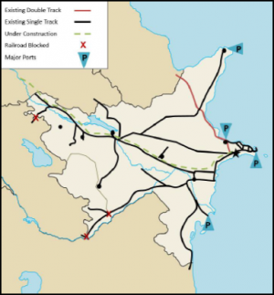
The Atropian State Railway operates 1,319 miles of broad gauge (5 foot) railroad track with 794 miles or 60% of the track operated by electricity. One of the three main tracks follows the same basic route as highways M2 and M3 from Donovia along the Caspian Sea to Ariana. The second main track follows the same general route as highway M1 from Baku to the Gorgas border. A recently completed third track connects Rimzi with the east-west track just east of Mingachevir. Due to the current conflict with Limaria over the Lower Janga region, the rail lines are blocked at all Limarian and Lower Janga borders.
Baku began to build its subway in 1951 and remains the only Atropian city large enough to operate a subway system. The Baku Metro currently operates 22 stations on 21 miles of track along two main lines. The two main metro lines cross at Baku Central Station. About five years ago, officials announced plans to construct 41 new metro stations in Baku over the following 17 years, but construction only began recently. The Baku Metro closes between 0100 and 0600 hours daily. The subway’s continued operation reduces the amount of vehicular traffic on the city’s streets.
Air Transportation Systems
All five countries maintain both paved and unpaved runways of varying distances. Many of the unpaved runways resemble nothing more than a cleared dirt path only suitable for the sturdiest of planes.
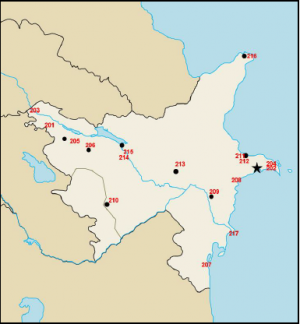
Atropia contains a total of 36 airports with 31 paved and eight unpaved runways. All unpaved runways in Atropia do not exceed 3,000 feet. The map on the next page shows the location of Atropia’s major runways and the chart below shows the details for each runway. Atropia’s runways (not all shown on the map and chart) by length include the following:
Paved Runways
- Over 10,000 feet: 4
- 8,000 to 10,000 feet: 8
- 5,000 to 8,000 feet: 14
- 3,000 to 5,000 feet: 4
- Under 3,000 feet: 1
Unpaved Runways
- Over 10,000 feet: 0
- 8,000 to 10,000 feet: 0
- 5,000 to 8,000 feet: 0
- 3,000 to 5,000 feet: 0
- Under 3,000 feet: 8
Major Runways
- PEM=Porous European Mix
| Map # | Elevation (Feet) | Latitude (D, M, S) | Longitude (D, M, S) | Length (Feet) | Width (Feet) | Surface Type |
| 201 | 1079 | 41 07 22.01N | 45 25 21.80 E | 7098 | 115 | Asphalt |
| 202 | 935 | 40 24 24.00 N | 50 12 01.00 E | 3966 | 120 | Asphalt |
| 203 | 40 | 41 45 12.22 N | 46 21 19.04 E | 8670 | UNK | UNK |
| 204-1 | 10 | 40 28 03.00 N | 50 02 48.00 E | 8858 | 197 | Asphalt |
| 204-2 | 10 | 40 28 03.00 N | 50 02 48.00 E | 10499 | 149 | Concrete |
| 205 | 1099 | 40 53 15.44 N | 45 57 25.25 E | 8182 | 135 | Concrete |
| 206 | 1083 | 40 44 06.00 N | 46 19 06.00 E | 8202 | 144 | Concrete |
| 207 | 30 | 38 44 46.70 N | 48 49 04.61 E | 5172 | 148 | Asphalt |
| 208 | UNK | 40 07 46.00 N | 49 27 16.00 E | 7619 | UNK | PEM |
| 209 | UNK | 40 02 12.00 N | 48 54 26.00 E | 6559 | UNK | Concrete |
| 210 | 2001 | 39 54 03.62 N | 46 47 11.65 E | 7304 | 120 | Asphalt |
| 211 | -1 | 40 35 29.69 N | 49 33 26.78 E | 8218 | 132 | Concrete |
| 212 | UNK | 40 48 30.00 N | 49 25 55.00 E | 8199 | UNK | Concrete |
| 213 | -3 | 40 16 24.92 N | 48 09 48.84 E | 8200 | 130 | Concrete |
| 214 | UNK | 40 44 36.00 N | 46 51 26.00 E | 7539 | UNK | Asphalt |
| 215 | UNK | 40 37 57.00 N | 47 08 28.00 E | UNK | UNK | UNK |
| 216 | 15 | 42 06 38.24 N | 49 43 45.84 E | 10055 | 150 | Concrete |
| 217-1 | -5 | 39 22 05.80 N | 49 16 00.53 | 8001 | 200 | Concrete |
| 217-2 | -5 | 39 22 05.80 N | 49 16 00.53 | 8002 | 200 | Concrete |
| 217-3 | -5 | 39 22 05.80 N | 49 16 00.53 | 7137 | 200 | Concrete |
Airports/Airlines
Atropia Airlines serves the country as its national airline carrier. Atropia Airlines flies internationally to 19 different cities in 14 European and Asian countries. Two international airports operate in Atropia at Baku and Ganja. Atropia possesses enough airports with sufficient runways to support most military operations in the area.
Maritime Seaports
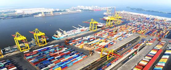
Atropia has 1 seaport located in the Caspian Sea. While the Port of Baku does average over 25 million tons of cargo throughput annually, the port can’t accommodate Military Sea Lift (MSC) Commands Large, Medium-Speed Roll-on/Roll-off (LMSR).The Baku International Sea Port (BISP) serves as the largest and most important port on the Caspian Sea. Between April and November each year, ships can load and unload their cargo at the BISP from any destination in the world by the use of Donovian waterways, as they are ice-free in those months. The BISP contains terminals for cargo, oil, passengers, and ferries. It can handle up to 15 million tons of liquid products and 10 million tons of dry products annually. A fleet of 20 ships composed of tugs, skimmers, pilot boats, fireboats, and crane ships provide support to the BISP.
The BISP main cargo terminal can simultaneously accommodate six ships of 2,841 feet in length that reach an underwater depth at the pier of 22 feet. The quays include one pier available for RO- RO ships. Sixteen cranes can offload cargo that weighs from 5-40 tons, and available forklifts can lift anything from 10-105 tons. Stevedores can simultaneously offload three ships daily and transfer the cargo to up to 100 semi-trucks and 150 railroad cars through the use of four diesel locomotives. Shippers can use 258,334 square feet of open storage space and 107,639 square feet of warehouse space for temporary storage. The main cargo terminal can currently handle up to 15,000 40-foot equivalent units (FEUs) annually, with up to 17,222 square feet of temporary storage space for shippers. FEU forklifts can handle any weight up to 42 tons, and the area links directly to the main railway line.
The BISP oil terminal can simultaneously handle up to four oil tankers that can carry 5,000 to 13,000 tons of oil at a time at two piers, with the ability to process up to 15 million tons per year. Atropia also operates another oil harbor 25 miles from Baku on the Tramaz Peninsula. This terminal can berth eight tankers simultaneously, with four quays that accommodate two tankers each. The Baku ferry and passenger terminals provide service for the local transfer of cargo and people around the Caspian Sea area between the ports at Baku, Turkmenbashi (Turkmenistan), Aktau (Khazakstan), and several Ariana ports. The ferry terminal possesses the capacity to move eight million tons of cargo annually, and on each trip the ferry can accommodate 40 semi-trailers (28 wagons), 50 cars, and 202 passengers. Smaller boats can navigate the last 310 miles of the Kura River within Atropia before the Kura River reaches the Caspian Sea. Another eight large non-navigable rivers originate in the Caucasus Mountains and drain Atropia’s central lowlands basin.
Winter freezes waterways into the Caspian Sea from the north and restricts the use of the BISP for military operations in the months from November through April. In the open months, ships must receive safe passage through Donovia to use the northern waterways by which small ships can navigate all the way to the North Sea. If the Caspian Sea route remains available for military use, the BISP possesses enough piers, equipment, and storage space to conduct military operations. The Atropian seaports, however, remain open year-round for intra-Caspian Sea transportation of goods and personnel. Atropia ranks 52nd in the world’s merchant marine fleet rankings. The Atropian fleet includes 26 cargo ships, 2 passenger, 9 passenger/cargo, 46 petroleum, 3 specialized tankers, and 3 Roll On-Roll Off (RO-RO) ships. Atropia ranks 52nd in the world’s merchant marine fleet rankings. The Atropian fleet includes 26 cargo ships, 2 passenger, 9 passenger/cargo, 46 petroleum, 3 specialized tankers, and 3 Roll On-Roll Off (RO-RO) ships.
.
.
.
.
.
.Pipelines
The security of hydrocarbon pipelines will be paramount in any military operations in the Caucasus region. Any disruption to the flow of crude oil and natural gas to the Western world could cause economic problems, as many modern countries rely on hydrocarbons to fuel their industries.
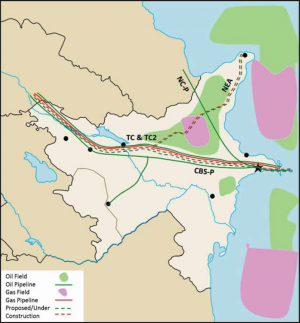
Atropia operates three major oil pipelines and one natural gas pipeline within the country. Any disruption to the flow of oil from the Caspian Sea fields will affect Western Europe and many American allies. British Petroleum operates the Trans-Caucasus petroleum (TC-P) pipeline that moves oil from the Caspian Sea fields to tankers in the Mediterranean Sea. The pipeline stretches 1,110 miles from Baku through Gorgas, and eventually reaches the Mediterranean Sea. While not the shortest or quickest route from Baku, the chosen route avoids the turmoil and possible interruptions due to potential conflicts in Limaria, and does not allow Donovia to control the world’s access to the Caspian Sea’s hydrocarbon resources. The pipeline also provides another outlet for the oil-rich Middle East besides tankers that must travel through the Persian Gulf chokepoint at the Strait of Hormuz.
The older North Caucasus petroleum (NC-P) pipeline runs about 830 miles from Baku to Novorossiysk, Donovia, and last year moved approximately 29,000 barrels per day (bbl/d) to Donovia’s Black Sea port. Over the last decade, this pipeline increased its throughput from 12,000 bbl/d but, because of the TC-P pipeline, continues to operate at only one-third capacity.
The third major pipeline is the Caspian & Black Seas petroleum (CBS-P) pipeline, which also begins at Baku and runs over 516 miles to the Black Sea port at Supsa, Gorgas. Atropia closed this pipeline five years ago for repairs, and the Donovia-Gorgas conflict two years later delayed its reopening by three months. Three years ago, it averaged only 13,000 bbl/d. However, as of last year, an average of 55,000 bbl/d passed through its pipes.
The natural gas pipeline in Atropia and Gorgas is the Trans-Caucasus natural gas (TC-G) pipeline, which follows the same paths as the TC-P pipeline.
Four new pipelines are under construction in Atropia, all built to avoid crossing Donovia and its ever-increasing “transit fees.” European consortiums are building two of these to access the fields in Central Asia. These new oil and gas pipelines will originate in Central Asia, cross the Caspian Sea, and then follow the TC-P and TC-G pipelines through Atropia and Gorgas en route to European markets. Referred to as the Trans-Caucasus 2 petroleum (TC2-P) and natural gas (TC2-G) pipelines, they will double the capacity of the current pipelines. Two more pipelines, known as the Northeast Atropian petroleum (NEA-P) and natural gas (NEA-G) pipelines, are to carry hydrocarbons from newly discovered fields in northeast Atropia. These will eventually span from the hydrocarbon boom town of Rimzi on the Caspian Sea to the TC-P and TC-G pipelines.
Telecommunications Architecture
For the most part, Caucasus-region residents use cellular telephones to communicate with each other due to the lack of landline telephone infrastructure. Many residents never owned any type of telephone until they received their first cellular phone. Most can access news from either television or radio, but some rural residents have no information access via modern methods.
In Atropia, most citizens can access a telephone and listen to a television or radio broadcast, but Internet access remains quite limited. Despite the rapid growth of the Atropian telecommunications infrastructure over the last decade, much of the equipment needs replacement or modernization. The Atropian telephone system remains generally inadequate, with only 18 main telephone lines per 100 citizens. The Atropian government owns and operates a telecommunications monopoly within the country. Many Atropian cable and microwave systems are over 30 years old and now show signs of their age. Atropians operate 1.5 million landlines and 6.4 million cellular telephones. Ten FM, 11 AM, and one shortwave radio station function within Atropia, and there are 10 television stations in operation. Atropia connects internationally through the Trans-Asia-Europe (TAE) fiber-optic link. A total of 1,274,610 Atropians use the Internet regularly, but 1.45 million Atropians, or 17% of the population, can access the Internet. The military will be able to communicate with the vast majority of Atropia’s populace as they can receive information from the radio, TV, or the Internet.
Industry
Because of their hydrocarbon resources, Ariana, Atropia, and Donovia are more industrialized than Gorgas and Limaria. Industry GDP ranges from a low of 27.1% in Gorgas to a high of 61.4% in Atropia. The protection of the Atropian hydrocarbon infrastructure remains paramount for any military operations in the area, and the military should refrain from unnecessary damage to the industrial sector to facilitate economic recovery after the end of hostilities. The Atropian government spends most of its revenue to ensure the modernization of its hydrocarbon resources while it neglects maintenance of much of the rest of its infrastructure. Atropia produces a large amount of toxic industrial chemicals for multiple purposes, including hydrocarbon production activities, water purification, wastewater management, and fertilizer to increase agricultural output.
Agriculture
Agriculture production still dominates the labor forces of Gorgas (55.6%) and Limaria (46.2%), but not Ariana (25%), Atropia (38.3%), or Donovia (20%). Even in the Caucasus region’s predominately agricultural countries, farming creates less than one-fourth of the country’s Gross Domestic Product (GDP). Except for Atropia, the region relies on food imports to feed its people. Any food import disruption may increase the military’s burden to feed civilians and prevent starvation.
Nearly 40% of all Atropians engage in agricultural pursuits, but it creates less than 6% of the country’s GDP. Almost all Atropian farmers (99.98%) work on small private farms that average approximately five acres. Atropians cultivate approximately 23% of their land, but they irrigate 74% of the land they farm. Almost 25,000 miles of canals and water pipelines satisfy the needed water requirements.
Five crops constitute 80% of all Atropian agricultural production: grapes, cotton, tobacco, citrus fruits, and vegetables. The first three represent over 50% of annual crops while the latter two make up the remainder. The Atropian climate, however, remains diverse enough to produce peaches, almonds, and rice. Other major Atropian crops include apples, olives, persimmons, raspberries, strawberries, currants, plums, pears, pomegranates, tomatoes, potatoes, carrots, beets, cabbage, cucumbers, onions, wheat, maize, and barley.
Oil
Since the 1870's, Atropia’s oil industry has served as the engine that runs the country’s economy and will continue to do so for the foreseeable future. The irony remains, however, that the oil industry is still largely responsible for Atropia’s previous pollution problems and practices left over from the pre-1991 era, and continues to generate additional pollution problems today.
During the past 14 years, Atropia quadrupled its oil production to rise from the world’s 35th largest crude oil producer to the 23rd largest. Very recently discovered oil reserves in northeast Atropia will continue to make the country an even more important player in the world marketplace. The Atropian National Oil Company (ANOC) operates two national refineries, manages the pipeline system, and handles all oil export and import duties.
Atropia’s abundant but hard-to-reach oil reserves attract foreign investors because of the world’s dependency on fossil fuels and Olvana's increased energy demands. thirteen years ago, the European Bank for Reconstruction and Development (EBRD) provided $5 million to set up a $40 million revolving loan base to finance the rehabilitation of old onshore Atropian oil fields. These funds initiated tertiary extraction methods to recover additional oil from 720 wells in the Mugan 1 field and 190 wells in the Mugan 2 field. Both sites are located approximately 50 miles southwest of Baku in desert or semi- desert climates. The loans also provided funds to improve current oil/water separation equipment and storage tanks; drill additional wells; and establish a remediation program to clean up abandoned oil infrastructure such as pipelines, tanks, and reserve pits on both oil fields.
Gas
Five years ago, because of the Pasha Sarak natural gas field’s production levels, Atropia changed from a net natural gas importer to a natural gas exporter. The EBRD led a bank syndicate that provided $110 million to complete the first stage of a $277.7 million project to tap the Pasha Sarak natural gas fields. Atropia produced five billion cubic meters of natural gas seven years ago but last year increased its production to over 16 billion cubic meters—an increase of 323%. Production continues at the latest level cited above. Beginning seven years ago, Atropia has climbed steadily from 47th in the world to their current position as the 32nd largest natural gas producer in the world.
Due to Atropia’s large reserves of 849 billion cubic feet (current estimate), other countries such as Donovia want to gain additional access to the Caspian Sea area’s natural gas fields. Additional gas fields discovered in hydrocarbon-rich northeast Atropia will only extend the length of time that the country can continue to export natural gas to the Western world. Increased energy requirements expected in the future will make other foreign countries’ access to Atropia’s natural gas even more important. About two years ago, Atropia began the daily shipment of 1.5 million cubic meters of natural gas to Donovia. This initiated fulfillment of a previous contract signed by the two countries for Atropia to provide 500 million cubic meters of natural gas annually to Donovia. Later, the two countries agreed to double the amount to 1 billion cubic meters of natural gas annually.
Pollution
All five Caucasus-region countries face significant pollution problems stemming from poor industrial practices. The governments cared more about natural resource extraction and industrial production than the stewardship of the planet. This lack of concern for the environment occurred regardless of which government was in power. The region’s military operations will need to address pollution, with soldiers taking precautions due to high-level air pollution and units considering any local water source not potable until tested.
Atropia faces a wide variety of pollution issues to include factory air pollution, ground water contamination, inadequate waste management, and genetic mutation. Much of the pollution remains from the 1950s–1970s when leaders cared more about product creation in the oil and chemical fields than the protection of the environment. About five years ago, Scientific American named Sumgayit, Atropia, as one of the top 10 most polluted locations in the world. Despite increased awareness of pollution for two decades, many factories continue to operate inefficiently and in an environmentally unfriendly manner just as the factories did in the past. The pollution has caused Caspian Sea caviar and fish yields to decline and continues to cause birth defects in Atropian babies.
Summary
Due to Atropia’s rise to in ranking as a world hydrocarbon exporter, much wealth continues to flow into the country. The Atropian government continues to pump much of the increased revenues back into either the extraction of oil and gas in the Caspian Sea fields or the transportation of hydrocarbon products out of the country. Atropia should continue to increase its infrastructure for the next generation due to its hydrocarbon resources, but it may come at an expense to its environment due to increased pollution.

