Physical Environment: Amari
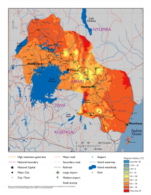
Amari is a moderately large country located in eastern Africa. It borders two major bodies of water: the Indian Ocean and Lake Victoria. The country’s terrain varies from high mountains and green plateaus to desert lowlands and coastal plains, with climates ranging from tropical to semiarid to sub-alpine. Multiple natural hazards exist, resulting from Amari’s geology, weather, native wildlife, and human activity.
Contents
Table of Physical Environment Data
| Measure | Data | Remarks |
|---|---|---|
| Total Area (sq miles) | 196,575 | Includes inland water |
| Land Area (sq. miles) | 176,619 | Excludes inland water |
| Inland Water (sq. miles) | 19,956 | Includes Lake Victoria, Lake Albert, and Lake Kyoga |
| Inland Border (miles) | 2,341 | Kujenga (517), Nyumba (773), Ziwa (437) |
| Coastline (miles) | 2,273 | Indian Ocean (817), Lake Victoria (1,312), Lake Albert (144) |
| Highest Elevation (ft.) | 19,341 | Mt Kilimanjaro |
| Lowest Elevation (ft.) | 0 | Sea level |
| Arable (cultivated) Land (%) | 37% | Primarily in the west |
| Permanent Crops (%) | 8% | west |
| Permanent Pasture (%) | 35% | east |
| Irrigated Land (%) | 4% | east++ |
| Forested Land (%) | 11% | central & west++ |
| Urban Area (%) | <2% | primarily Nairobi and Kampala |
Terrain
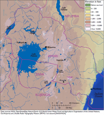
Amari’s land area is 196,575 square miles in the eastern part of central Africa. It shares 3,158 miles of border with several different countries, including Kujenga and Ziwa to the south and Nyumba to the north, and two major bodies of water—the Indian Ocean and Lake Victoria. The country’s varied terrain includes mountainous highlands, high plateaus, deep valleys, lowland plains, and sandy beaches.
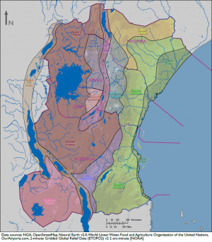
Roughly rectangular in shape, Amari’s long axis runs northwest to southeast. Beginning at the former, Amari’s northwest border runs along the Western Rift Valley and part of Lake Albert. Steep 1,000-ft high bluffs separate the valley from the western plateau, which includes part of Lake Victoria in the south. Continuing southeast, the mountainous central highlands come next and consist of two parts—western and eastern—that are divided by the Eastern Rift Valley. The east-central highlands descend to the eastern lowlands and then to the coastal plains on the Indian Ocean. Pemba Island (340 sq. miles) lies southeast of the mainland and is the country’s southernmost land mass. The highest point in Amari is Mt. Kilimanjaro at 19,341 feet, while the lowest is at sea level on the Indian Ocean coast.
Border Disputes
The Tanga region, a small triangle of land defined by the far southeastern Amari border, the Pangani River, and the Indian Ocean formally belongs to Kujenga. However, its populace identifies with Amari, and wishes to join that country. Though the land is not disputed per se, the situation occasionally leads to political tensions between these two neighbors. Armed outbreaks occur episodically, primarily between the local populace and Kujengan security forces, though Amarian security forces have also been involved.
Bodies of Water
Amari’s most prominent bodies of water are the Indian Ocean to the east and Lake Victoria in the southwest. The country shares maritime borders on the Indian Ocean with Nyumba and Kujenga, and operates a major deepwater port at Mombasa. The ocean is a major source of fish, both for internal consumption and for export, which occasionally leads to quarrels between Amari and its neighbors. Recent discoveries of natural gas in Amarian waters could be another source of conflict.
Lake Victoria is also a major fishing resource, shared between Amari, Kujenga, and Ziwa. The second-largest lake in the world and the largest tropical freshwater lake, it covers over 26,500 square miles and reaches a maximum depth of approximately 270 feet. Used for fishing, transportation, and drinking (despite pollution issues), the lake is also the subject of occasional disputes, particularly by those living near—or making their living from—the lake. These incidents typically increase in frequency and severity during periods of extended drought, when the lake can decrease significantly in size.
Other prominent lakes in Amari include Lake Albert and Lake Kyoga. Lake Albert lies on the western border, and is shared with the country’s western neighbor. It has a surface area of around 2,100 square miles and a maximum depth of approximately 185 feet. Overfishing and pollution on the lake have decreased its usefulness to Amari in recent years, though it is used for transportation. Additionally, a recent discovery of a major petroleum deposit in the area is drawing considerable national and international interest. Lake Kyoga is located in western Amari, north of Lake Victoria and east of Lake Albert. It consists of a main east-west basin with two northern branches, known as Lake Kwania and Lake Kojweri. The entire body of water covers around 660 square miles and reaches a maximum depth of less than 25 feet. Swampy in nature, it is home to crocodiles as well as fish. Despite this, the lake is still navigable by shallow-draft steamer boats from Galiraya, on the southern shore, to its western end.
Amari’s multiple rivers can be grouped into eastern or western, depending on which side of the Eastern Rift Valley they fall on. None of these rivers are navigable by deep-draft vessels, but portions of some of them can be used by small, shallow-draft craft such as steamboats. Navigable portions are usually located near larger bodies of water, such as the Indian Ocean or Lake Victoria. In the west, the most important river is the Victoria Nile, which consists of two distinct sections. The first starts at Lake Victoria and flows northward into Lake Kyoga, while the second flows out of Lake Kyoga and into Lake Albert. Three hydropower stations, all located on the first section of the river, supply around a third of country’s electricity.
The Albert Nile flows out of Lake Albert just north of where the Victoria Nile enters, and runs northward out of the country. The river forms a portion of the border between Amari and its western neighbor. The Mara River, in the south, forms part of the border between Amari and Ziwa. Other important rivers in the western half include the Acuwa, Kafu, Katonga, Lugo, Nzoia, Page, Suam, and Turkwel.
In the eastern part of the country, the Athi and Tsavo Rivers run primarily eastward, where they merge to form the Galani River that flows into the Indian Ocean. The Tana River forms a considerable portion of the eastern border between Amari and Nyumba to the north. It is used for irrigation and hydroelectric power. The Pangani River forms part of the border between Amari and Kunjenga in the south. The only other major river in the east is the Ewaso Ngiro, which flows northward into Nyumba.
Mobility Classification
Movement in Amari is less restricted in the western plateau and lowland plains than in other regions. Steep escarpments separate the two Rift Valleys from their surrounding terrain; both valleys contain active volcanoes. Glaciers exist on Amari’s highest peaks, while forests and mangroves hamper movement along the coastal plains. Mountainous terrain and rough roads make it hard to transport troops and equipment overland. Multiple rivers and streams—especially in the western half to the country—also challenge mechanized and motorized movement. Roads can become flooded during the rainy season, making them impassable. These rains also greatly affect visibility for reconnaissance and air operations. Foot movement is also limited in the central highlands by the negative effects of the high altitudes.
Natural Hazards
Both natural disasters and manmade hazards exist in Amari. Natural disasters include flooding, earthquakes, limited volcanic activity in the Rift Valleys, landslides, windstorms, and hailstorms. Frequent droughts, including one ongoing for the past two years, can lead to famine. Violent thunderstorms with gusty winds are common on and around Lake Victoria. Water pollution is an issue, caused by urban waste, industrial waste, and contamination by pesticides and fertilizer. Overharvesting of trees for fuel led to significant deforestation and in turn soil erosion and desertification, especially in the eastern lowlands. Unexploded ordnance, including landmines, can be found in previous conflict zones. Dangerous indigenous wildlife include disease-carrying mosquitoes and tsetse flies, as well as more traditional threats: big cats (e.g., lions), crocodiles, elephants, gorillas, hippopotamuses, hyenas, rhinoceroses, warthogs, and wild dogs.
Subterranean Environment
The Amarian government has developed some underground facilities (UGFs), including structures to protect vital space program assets, bunkers for ammunition, and underground/hardened command posts. Subterranean systems used by criminal actors consist primarily of tunnels located on main smuggling routes, usually crossing the Amari-Kujenga border east of Lake Victoria. It is relatively easy to cross international borders in the region without detection, so tunnels are minimal in number and concentrated along routes more frequently patrolled by government forces. Insurgent use of such systems is minimal except in and around the Tanga region of Kujenga, where tunnels and underground rooms are used to avoid detection by local authorities. Natural caves are found throughout the country and in the Tanga region, and are used by criminals, insurgents, and local citizens alike.
Vegetation
Vegetation in Amari varies by topographical region. The Western Rift Valley and most of the western plateau consist primarily of savanna, with some forests in the swampy areas of the far southwest. The central highlands and Eastern Rift Valley contain most of the country’s forests, giving way to savanna in the far north and the east. The highest elevations are host to glaciers. The eastern lowlands are primarily grassland or desert scrub. The coastal plains have both grasslands and forested areas; mangrove forests grow on the coastline. Trees found in the country include both deciduous and evergreen, including species such as acacia, bamboo, baobob, cacti, candelabra, cedar, euphorbia, giant lobelia, groundsel, heath, miombo, papyrus, and podo.
Agriculture
Amarian agriculture employs 60% of the labor force full-time and an additional 15% part-time, producing 30% of the national GDP. The western region plays a very important role in this sector. Over one-third of Amari’s land is arable. Most farming takes place in the highlands or on the western plateau; much of the remainder of the country is either used for pasture or covered with forests or scrub vegetation. Due to reasonable rainfall, most irrigation in the country occurs in the drier eastern region. Crops produced in Amari include bananas, beans, beets, cabbages, carrots, cashews, cassava, citrus fruit, cocoa, coconut, coffee, corn, cotton, flowers, fruit, groundnuts, khale, legumes, mango, millet, oats, onions, palms (oil), peppers, pineapple, plantains, potatoes, pyrethrum, rice, sisal, sorghum, soybeans, sugarcane, sweet potato, tea, tobacco, tomatoes, turnips, vegetables, and wheat. Of these, cashews, coffee, cotton, cut flowers, pyrethrum, sisal, and tea are exported. Despite the large agricultural economy, the country does not grow enough cereal grains to feed its populace.
Livestock and Wildlife
Amarians have considerable livestock, especially in the drier regions where crop cultivation is more difficult. Common domesticated animals include bees, cattle, pigs, sheep, goats, and poultry. The country also boasts multiple types of wildlife, including aardvark, African buffalo, numerous different kinds of antelope, several species of big cat (cheetah, leopard, lion, wildcat), bush baby, crocodile, elephant, giraffe, hippopotamus, hyena, hyrax, mongoose, many types of primate (baboon, chimpanzee, gorilla, monkey), rhinoceros, warthog, wild dog, and zebra. While some of these species are only found in national parks and game reserves in Amari, others are more widespread. Many of these species are endangered and protected by Amarian law. Poaching is a continuing problem, with elephants and rhinoceroses being the most common targets. A couple of Amari’s game reserves are shared by Nyumba to the north and at times have been a source of contention because of the lack of national security forces in the parks, ivory smuggling, big game poaching, and drug trafficking occur through the border preserves.
Climate and Weather
Amari has a widely varied climate depending on location and altitude. The Western Rift Valley and western plateau experience a tropical wet and dry climate defined by rainy and dry seasons. The central highlands and Eastern Rift Valley are temperate (highland climate), with the highest peaks experiencing a sub-alpine climate. The far-eastern central highlands and the eastern lowlands are primarily semiarid. The coastal plains are tropical, with high temperatures and humidity throughout the year.
Seasons
Amari’s seasons center around the long rains and the short rains, which alternate with two distinct dry seasons. Most of the country experiences the long rains from approximately March through May, the short rains during September through December, and intervening dry seasons in June through August and January through February. In the central highlands, the two rains merge into one long rainy season from March through December, with a single dry season during January through March. The hottest months are January through March, while the coolest are July through August. Temperatures usually vary more from day to night than from season to season.
| Season | Months | Remarks |
| Long Rains | March–May | |
| Dry | June–September | continued rain in the central highlands |
| Short Rains | October–December | |
| Dry | January–February |
Precipitation
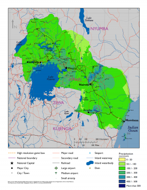
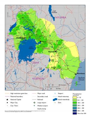
Precipitation in Amari varies primarily by season and latitude. Though usually taking the form of rain, snow is possible at extremely high elevations. Precipitation generally increases from north to south and with altitude. Much of the country receives between 1,000 and 1,500 mm of rain per year. The rift valleys and Lake Victoria vicinity and Coastal Plains receive between 1,500 and 2,000 mm. The eastern lowlands are by far the driest of the country, receiving only 250 to 1,000 mm.
| Location | Jan | Feb | Mar | Apr | May | Jun | Jul | Aug | Sep | Oct | Nov | Dec |
|---|---|---|---|---|---|---|---|---|---|---|---|---|
| Coastal Plains | 275 | 350 | 400 | 510 | 660 | 250 | 160 | 150 | 190 | 400 | 330 | 320 |
| Eastern Lowlands | ||||||||||||
| Rift Valleys | ||||||||||||
| Central Highlands | ||||||||||||
| Western Plains | ||||||||||||
| Lake Victoria |
Temperature-Heat Index
Monthly average high temperatures in Amari vary with elevation. Most of the country enjoys highs between 70–85°F, with the extreme elevations—above 8,000 feet—being cooler than this. Average highs in the eastern lowlands, the coastal plains, and the far north are hotter, ranging from 80–100°F. The combination of high temperatures and moderate to high relative humidity can quickly lead to both dehydration and heat exhaustion in the regions with lower altitudes.
| Location | Jan | Feb | Mar | Apr | May | Jun | Jul | Aug | Sep | Oct | Nov | Dec |
|---|---|---|---|---|---|---|---|---|---|---|---|---|
| Coastal Plains | val1 | val2 | val3 | val4 | val5 | val6 | val7 | val8 | val9 | val10 | val11 | val12 |
| Eastern Lowlands | val1 | val2 | val3 | val4 | val5 | val6 | val7 | val8 | val9 | val10 | val11 | val12 |
| Rift Valleys | val1 | val2 | val3 | val4 | val5 | val6 | val7 | val8 | val9 | val10 | val11 | val12 |
| Central Highlands | val1 | val2 | val3 | val4 | val5 | val6 | val7 | val8 | val9 | val10 | val11 | val12 |
| Western Plains | val1 | val2 | val3 | val4 | val5 | val6 | val7 | val8 | val9 | val10 | val11 | val12 |
| Lake Victoria | val1 | val2 | val3 | val4 | val5 | val6 | val7 | val8 | val9 | val10 | val11 | val12 |
Temperature-Wind Chill Index
Monthly average low temperatures in the highlands and plateau fall in the 40–55°F range, though lower temperatures can occur. The lowlands are warmer than this, while elevations over 8,000 feet may experience sub-zero temperatures and snow. The highest peaks in the country possesses a permanent snow cap. Cold and wind chill will not be an issue in the lower elevations, but can affect troops operating in the highlands.
Relative Humidity
Relative humidity in Amari is moderate to high in most regions. Average annual humidity in the Western Rift Valley and western plateau usually ranges from 65–80%, with level in the north and east being lower. Levels in the central highlands and Eastern Rift Valley average 55–70%, with higher altitudes experiencing higher relative humidity and vice versa. Averages in the eastern lowlands are also 55–70%, while those in the coastal plains are 65–80%.
| Location | Jan | Feb | Mar | Apr | May | Jun | Jul | Aug | Sep | Oct | Nov | Dec |
|---|---|---|---|---|---|---|---|---|---|---|---|---|
| Coastal Plains | val1 | val2 | val3 | val4 | val5 | val6 | val7 | val8 | val9 | val10 | val11 | val12 |
| Eastern Lowlands | val1 | val2 | val3 | val4 | val5 | val6 | val7 | val8 | val9 | val10 | val11 | val12 |
| Rift Valleys | val1 | val2 | val3 | val4 | val5 | val6 | val7 | val8 | val9 | val10 | val11 | val12 |
| Central Highlands | val1 | val2 | val3 | val4 | val5 | val6 | val7 | val8 | val9 | val10 | val11 | val12 |
| Western Plains | val1 | val2 | val3 | val4 | val5 | val6 | val7 | val8 | val9 | val10 | val11 | val12 |
| Lake Victoria | val1 | val2 | val3 | val4 | val5 | val6 | val7 | val8 | val9 | val10 | val11 | val12 |
Wind
Wind patterns change with the seasons in Amari and are associated with the dry seasons. The Kuzi monsoon winds blow from the southeast and peaks during the months of June through August. The winds then shift to the gentler northeast Kaskazi, which peak from December through March. Average wind speeds are less than 15 mph throughout most of the country. Though calmer when transitioning during the rainy seasons, the winds are strong enough to develop wind energy in certain areas. Thunderstorms with gusty winds are a frequent occurrence around Lake Victoria.
| Location | Jan | Feb | Mar | Apr | May | Jun | Jul | Aug | Sep | Oct | Nov | Dec |
|---|---|---|---|---|---|---|---|---|---|---|---|---|
| Coastal Plains | val1 | val2 | val3 | val4 | val5 | val6 | val7 | val8 | val9 | val10 | val11 | val12 |
| Eastern Lowlands | val1 | val2 | val3 | val4 | val5 | val6 | val7 | val8 | val9 | val10 | val11 | val12 |
| Rift Valleys | val1 | val2 | val3 | val4 | val5 | val6 | val7 | val8 | val9 | val10 | val11 | val12 |
| Central Highlands | val1 | val2 | val3 | val4 | val5 | val6 | val7 | val8 | val9 | val10 | val11 | val12 |
| Western Plains | val1 | val2 | val3 | val4 | val5 | val6 | val7 | val8 | val9 | val10 | val11 | val12 |
| Lake Victoria | val1 | val2 | val3 | val4 | val5 | val6 | val7 | val8 | val9 | val10 | val11 | val12 |
Summary
Amari’s terrain varies from rocky highland areas to flat lowland plains. The country’s rugged highlands create an obstacle for regional communication and make transport difficult. Natural disasters such as flood and drought will complicate missions. Troops must deal with extreme temperatures in the eastern lowlands, and high altitudes in parts of the central highlands. The spring-like weather in large portions of the highlands and western plateau will facilitate operations and maneuverability, as will the ease of mobility in the eastern lowlands.

