Physical Environment: Framland
Physical Environment Overview
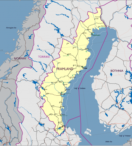
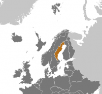
Framland extends from the midway Baltic Sea to north of the Arctic Circle. The country has an area of 99,520 km2, is 400 km long, bordering Torrike to the south and west, Bothnia to the north, and the Gulf of Bothnia to the east. Despite its northerly location, the climate is fairly mild and temperate, due to the warm Atlantic Gulf Stream. Annual precipitation varies from 500mm in the country’s western portions to 300 mm in the eastern portions. The growing season lasts 140 days and 100 days in the north. Most of Framland has a relatively even topography and is less than 300m above sea level with the highest ground only reaching 700m in altitude. Most Framish forests are part of the Boreal coniferous belt.
Table of Physical Environment Data
| Measure | Data | Remarks |
| Total Area (km2) | 99,520 | Borders Torrike to the south and west, Bothnia to the north, and the Gulf of Bothnia to the east. |
| Water Area (km2) | 8,707 | Lakes; Malren, Varnen, and Vattern |
| Land Area (km2) | 90,813 | |
| Land Border (km) | 1,599 | Torrike border - 1,466 and Bothnia border - 133 |
| Coastline (km) | 1,390 | Gulf of Bothnia |
| Arable Land (%) | ||
| Permanent Crops (%) | ||
| Irrigated Land (km2) | ||
| Forested Land (%) | 66 | About 4 million hectares |
Terrain
Most of Framland has a relatively even topography and is less than 300m above sea level. The country’s forest soils chiefly consist of moraines which were deposited when the inland ice cap melted 10,000 years ago.
Bodies of Water
Baltic Sea. The Baltic encompasses a large number of islands, shallow water and narrow channels; in the Tyr Archipelago alone, there are some 24,000 islands and islets. The exploitation of the economic zone in the Baltic Sea off Framland, and fishing rights in the area near the Torrikan border between the countries’ economic zones, is of particular concern and importance. While the disputes in this area have been relatively few and low‐key, the issue could over time, perhaps in combination with other contentious issues, take on increased importance and therefore potentially develop into a source of political conflict between the two nations. Closely related to their territorial economic disputes, there is an ongoing debate over the ownership of several small islands in vicinity of Gävle. Regardless of its current population, Framland claims historical ownership, as most of the islands mainly had Framish population at the time of dissolution of the Skolkan Empire.
Rivers. Most Framish rivers originate in Torrike. Torrikan exploitation of these rivers for hydro electrical purposes causes occasional friction between the two countries. The Framish argument is that Torrikan control over the water level in the rivers makes Framish hydro electrical production unpredictable. Another aspect of the dispute over water resources could have an impact on the fishery resources in the rivers that originate in Torrike and flow from west to east into the Baltic Sea.
Natural Hazards
Ice floes in the surrounding waters, especially in the Gulf of Bothnia, can interfere with maritime traffic.
A high level of air pollution, mainly originating abroad, has resulted in widespread soil acidification due to the low buffering capacity of Torrikan forest soils. Leaching of mineral nutrients has thus reduced their level by half in recent decades. Critical loads are being exceeded, both in terms of sulfur dioxide and nitrogen dioxide deposits. Air pollution poses a serious threat to the forest ecosystem and to the growth of forests.
Baltic Sea pollution problems. Tens of millions of people live in countries around the Baltic Sea. All of these countries are heavily industrialized. Intensive agriculture and forestry also takes place to a greater or lesser extent. The Baltic Sea is surrounded by a significant number of cities and densely populated areas, including ones with ports where there is frequent ship traffic. Over‐fertilization, i.e. the “unnaturally” substantial addition of the natural nutrients of nitrogen and phosphorous, is one of the worst problems for the health of the Baltic Sea. Because the Baltic Sea is an enclosed inland sea and the water turnover is slow, over‐fertilization is a particularly great problem here. The people who live around the Baltic Sea produce organic waste that ends up in the sea sooner or later. The most important sources of over‐fertilization are agriculture, which represents nearly 50% of the nitrogen leakage into the Baltic Sea, but the traffic and discharge of waste water also contribute. Contaminants of non‐degradable organic substances, metals and oil strongly affect the Baltic Sea’s animal life. These come from industries, wastewater, pesticides in agriculture and forestry, traffic and energy production and through long‐haul air transportation of toxic substances. All in all, these contaminants may have contributed a very negative effect on the Baltic Sea’s ecosystem over decades. However, countries around the Baltic Sea cooperate in a common international plan to reduce the discharges. Torrike, Framland, Arnland, Bothnia and other Baltic Sea countries are cooperating in the Baltic Marine Environment Protection Commission (BALCOM) in order to improve the situation. A common goal has been set up to protect and safeguard the marine environment in the Baltic Sea.
Vegetation
Most Framish forests are part of the Boreal coniferous belt. Due to the low buffering capacity of Framish forest soils, a high level of air pollution—mainly originating abroad—has resulted in widespread soil acidification. Leaching of mineral nutrients has thus reduced their level by half in recent decades. Critical loads are being exceeded, both in terms of sulfur dioxide and nitrogen dioxide deposits. Air pollution poses a serious threat to the forest ecosystem and to the growth of forests.
Land Cover
According to the Holdridge life zones system of bioclimatic classification, the capital Freja is situated in or near the boreal wet forest biome.
Framland’s greatest natural resource is its widespread forests, covering two‐thirds of the land, higher than in any other European country. Framland’s productive forests cover about 4 million hectares. Approximately 66% of the whole land area is covered with forests. Spruce and pine are by large the predominant species in Framish forests. These two species count for more than 80% of the timber stock. In Framland pine is the most common species.
Agriculture
The Framish agricultural sector (forestry and food industry not included) employs 3% of the Framish workforce. The growing season lasts 140 days and 100 days in the north.
The agricultural sector is a major source of pressure on Europe's environment. As a result, the agricultural sector is responsible for a large share of the pollution of surface waters and seas by nutrients, for the loss of biodiversity, and for pesticide residues in groundwater. Reforms in the 1990s, and measures taken by the sector itself, have brought about some improvements, but more is needed to balance agricultural production, rural development, and the environment. Modern, intensive agriculture often has a negative impact through its use and pollution of air, water and soil. Framland geographically is naturally well irrigated but further work is needed to reduce a decline in quality caused by salinization and land degradation. On the other hand, farming still plays a positive role in preserving Europe's landscapes and biodiversity.
Agriculture in Framland is of varying importance in different parts of Framland. This is due to different soils and different climate zones, with many parts of the country being more suitable to forestry. Wheat, rapeseed and other oil plants, and sugar beet are common in Southern Framland, while barley and oat is more important further north. The Framish agricultural sector (forestry and food industry not included) employs 57,900 people, which is 3% of the Framish workforce. There are 14 000 farms and other agricultural business. The average farm has 36 hectares (ha) of fields. Dairy farming is the largest sector in economic terms, and is responsible for 25% of the value of the Framish agricultural production. Pork and poultry production is also relatively large, while sheep and lamb production is quite small.
The Ministry of Rural Affairs is responsible for agriculture within the government of Framland. Areas of responsibility includes agriculture and environmental issues relating to agriculture, fishery, reindeer husbandry, horticulture, Sami affairs, animal welfare, foodstuffs, hunting and game management as well as higher education and research in the field of agricultural sciences.
The Ministry is divided into four specialist divisions:
- The Animal and Food Division
- The Rural Growth Division
- The Game Management, Fisheries and Sami Affairs Division
- The Agriculture and Forestry Division
Climate
Most of Framland has a temperate climate, despite its northern latitude, with four distinct seasons and mild temperatures throughout the year. The country can be divided into two types of climate; the southernmost part has a humid continental climate and the northernmost part has a subarctic climate. However, Framland is much warmer and drier than other places at a similar latitude, and even somewhat farther south, mainly because of the Gulf Stream. North of the Arctic Circle, the sun never sets for part of each summer, and it never rises for part of each winter. In the capital, Freja, daylight lasts for more than 18 hours in late June but only around six hours in late December. Framland receives between 950 to 1,650 hours of sunshine annually.
Temperatures vary greatly from north to south. Southern and central parts of the country have warm summers and cold winters, with average high temperatures of 20 to 25 °C and lows of 12 to 15 °C in the summer, and average temperatures of ‐4 to 2 °C in the winter, while the northern part of the country has shorter, cooler summers and longer, colder and snowier winters, with temperatures that often drop below freezing from September through to May. The highest temperature ever recorded in Framland was 36 °C in Gävle in 1948, while the coldest temperature ever recorded was −48.2 °C in Älvsbyn in 1966.
On average, most of Framland receives between 300 and 500 mm of precipitation each year, making it considerably drier than the global average. The western part of the country receives more precipitation, especially between altitudes of a 450m and 700m.
Seasons
| Season | Months |
| Winter | December to February |
| Spring | March to May |
| Summer | June to August |
| Fall | September to October/November |
Weather
Freja has a subarctic climate that has severe winters, no dry season, with cool, short summers and strong seasonality (Köppen-Geiger classification: Dfc).
Precipitation and Light Data
Annual precipitation varies from 500mm in the country’s western portions to 300mm in the eastern portions, making it considerably drier than the global average. The western part of the country receives more precipitation, especially between altitudes of a 450m and 700m.The longest day of the year is 20:15 hours long and the shortest day is 3:44 hours long.
| Average precipitation‐mm | Days with precipitation | Hours of sunshine | |
| JAN | 50 | 7 | 5:39 |
| FEB | 40 | 5 | 8:35 |
| MAR | 50 | 6 | 11:48 |
| APR | 30 | 9 | 15:08 |
| MAY | 40 | 13 | 18:22 |
| JUN | 60 | 14 | 20:30 |
| JUL | 30 | 13 | 19.28 |
| AUG | 40 | 15 | 16:25 |
| SEP | 40 | 14 | 13:05 |
| OCT | 40 | 15 | 9:45 |
| NOV | 50 | 12 | 6:32 |
| DEC | 60 | 9 | 4:28 |
Temperature Range
Mean temperatures range from 14/17° in July to between +1/ –14°C in January–February.
| Average high in °C | Average low in °C | |
| JAN | -2 | -12 |
| FEB | -2 | -13 |
| MAR | 0 | -8 |
| APR | 5 | -3 |
| MAY | 13 | 2 |
| JUN | 17 | 8 |
| JUL | 20 | 11 |
| AUG | 18 | 9 |
| SEP | 13 | 5 |
| OCT | 7 | 1 |
| NOV | 0 | -5 |
| DEC | -1 | -10 |
Relative Humidity
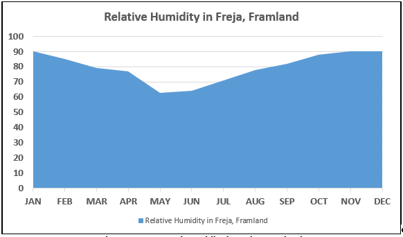
November is the most humid. On average, May is the least humid month. The average annual percentage of humidity is: 80.0%Wind
| Month | Direction | Speed (kts) |
| JAN | North West | 19 |
| FEB | South | 20 |
| MAR | South | 24 |
| APR | South | 22 |
| MAY | South | 27 |
| JUN | South | 19 |
| JUL | South | 19 |
| AUG | South | 17 |
| SEP | South | 19 |
| OCT | North West | 17 |
| NOV | North West | 19 |
| DEC | North West | 18 |
| Yearly Average | 20 |


