Physical Environment: Kujenga
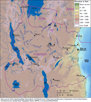
Kujenga is a large country located in central eastern Africa and is roughly rectangular in shape. It borders one major body of water: the Indian Ocean and encompasses three others, Lake Victoria, Lake Malawi, and Lake Tanganika. The country’s terrain varies from a significant rift valley in the central region, high mountains and arid desert lowlands, as well as coastal plains, with climates ranging from in the east, tropical to semiarid; warm desert in the west; and humid near the coast.
Contents
Table of Physical Environment Data
| Measure | Data | Remarks |
| Total Area (sq. miles) | 390,810 | Includes inland water |
| Land Area (sq. miles) | 364,374 | Excludes inland water |
| Inland Water (sq. miles) | 26,437 | Includes Lake Tanganyika, Lake Niassa, Lake Bangweulu, and Lake Rukwa |
| Inland Border (miles) | 3,073 | Amari (517), Ziwa (487) |
| Coastline (miles) | 2,834 | Indian Ocean (1,570), Lake Victoria (315), Lake Niassa (439), Lake Tanganyika (511) |
| Highest Elevation (ft.) | 11,220 | Mt Hanang |
| Lowest Elevation (ft.) | 0 | Sea level |
| Arable (cultivated) Land (%) | ||
| Permanent Crops (%) | ||
| Permanent Pasture (%) | ||
| Irrigated Land (%) | ||
| Forested Land (%) | ||
| Urban Area (%) |
Terrain
Kujenga’s area is 390,810 square miles in the eastern part of central Africa. It shares 3,073 miles of border with several different countries, including Amari and Ziwa to the north, and four major bodies of water—the Indian Ocean, Lake Victoria, Lake Tanganyika, and Lake Niassa. The country’s varied terrain includes mountainous highlands, high plateaus, deep valleys, lowland plains, and sandy beaches.
Border Disputes
The Tanga region, a small triangle of land defined by the far southeastern Amari border, the Pangani River, and the Indian Ocean formally belongs to Kujenga. However, its populace identifies with Amari, and wishes to join that country. Though the land is not disputed per se, the situation occasionally leads to political tensions between these two neighbors. Armed outbreaks occur episodically, primarily between the local populace and Kujengan security forces, though Amarian security forces have also been involved.
Bodies of Water
Kujenga has the longest Indian Ocean coastline of the DATE Africa countries. It also has the most inland water area, dominated by the great lakes of the African Rift Valleys. From the south, these include Lakes Nyassa (Malawi), Tanganyika, and Victoria. Significant, but lesser freshwater lakes dominate the south, and the alkali Lakes Eyasi and Natron form Kujenga's border with Ziwa.
The 830 km Ruvuma River forms the southern boundary of Kujenga, flowing to the Indian Ocean. The much smaller Umba River forms the Amari-Kujenga border, also terminating at the Indian Ocean.
Mobility Classification
Similar to Amari, Kujenga is characterized by relatively broad a coastal plain gradually rising to a plateau as you travel westward. This corridor is relatively unrestricted all the way to the western frontier at the Kigoma on Lake Tanganyika. Terrain remains unrestricted on a northward branch of this corridor, all the way to the southern shore of Lake Victoria in Ziwa. Not surprisingly, the DARGOMA rail and road corridors follow this route.
Access to the southwestern corner of Kujenga becomes more restricted as the plateau gives way to highlands at the convergence of the East and West Rift Valleys around Mbeya. Travel further west from Mbeya is further hampered by rougher terrain and denser vegetation and wetlands. A well-established road and rail corridor runs southwest from Dar Es Salaam, through Mbeya past Kujenga's southwestern frontier to Lusaka with further connection to southern African cities.
Natural Hazards
Of the hazards listed in the regional assessment, the water and wetland obstacles in far eastern Kujenga are the most challenging. The Kujengan Bush Militia and other armed groups take advantage of these obstacles when selecting bases and areas of operation.
Subterranean Environment
The Amboni cave network, near Tanga in the northeast, is series of 10 limestone caves believed to be East Africa's largest. Though not fully exploited, they have provided safe haven for armed groups operating on the Kujenga-Amari border.
Vegetation
To be published
Agriculture
To be published
Livestock and Wildlife
To be published
Climate and Weather
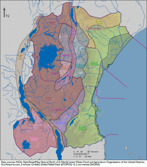
Kujenga has a widely varied climate depending on location and altitude. The Western Rift Valley and western plateau experience a tropical wet and dry climate defined by rainy and dry seasons. The central highlands and Eastern Rift Valley are temperate (highland climate), with the highest peaks experiencing a sub-alpine climate. The far-eastern central highlands and the eastern lowlands are primarily semiarid. The coastal plains are tropical, with high temperatures and humidity throughout the year. Unique to Kujenga is the Southern Plateau at the southern confluence of the Rift Valleys. It experiences greater rainfall, heat and humidity that the Western Plateau.
East African Monsoon characteristics:
Coastal Plain: The dry season lasts throughout June to October when rainfall is highly unusual (even on the islands). Heavier rainy season March-May with lighter “short” rainy season from November to December. Maximum temperatures range from 30 to 35 degrees Celsius from September-February. The East African coastal alignment is northeast to southwest, resulting in NE trade winds blowing parallel to the coast and seldom blowing inland.
Seasons
Kujenga’s seasons center around the long rains and the short rains, which alternate with two distinct dry seasons. Most of the country experiences the long rains from approximately March through May, the short rains during September through December, and intervening dry seasons in June through August and January through February. In the central highlands, the two rains merge into one long rainy season from March through December, with a single dry season during January through March. The hottest months are January through March, while the coolest are July through August. Temperatures usually vary more from day to night than from season to season.
| Season | Months | Remarks |
| Long Rains | March–May | |
| Dry | June–August | continued rain in the central highlands |
| Short Rains | September–December | |
| Dry | January–February | January-March in central highlands |
Precipitation
| Location | Jan | Feb | Mar | Apr | May | Jun | Jul | Aug | Sep | Oct | Nov | Dec |
|---|---|---|---|---|---|---|---|---|---|---|---|---|
| Tanga | val1 | val2 | val3 | val4 | val5 | val6 | val7 | val8 | val9 | val10 | val11 | val12 |
| Morogoro | val1 | val2 | val3 | val4 | val5 | val6 | val7 | val8 | val9 | val10 | val11 | val12 |
| Dodoma | val1 | val2 | val3 | val4 | val5 | val6 | val7 | val8 | val9 | val10 | val11 | val12 |
| Tabora | val1 | val2 | val3 | val4 | val5 | val6 | val7 | val8 | val9 | val10 | val11 | val12 |
| Kigoma | val1 | val2 | val3 | val4 | val5 | val6 | val7 | val8 | val9 | val10 | val11 | val12 |
| Mbeya | val1 | val2 | val3 | val4 | val5 | val6 | val7 | val8 | val9 | val10 | val11 | val12 |
| Kasama | val1 | val2 | val3 | val4 | val5 | val6 | val7 | val8 | val9 | val10 | val11 | val12 |
Temperature-Heat Index
| Location | Jan | Feb | Mar | Apr | May | Jun | Jul | Aug | Sep | Oct | Nov | Dec |
|---|---|---|---|---|---|---|---|---|---|---|---|---|
| Tanga | val1 | val2 | val3 | val4 | val5 | val6 | val7 | val8 | val9 | val10 | val11 | val12 |
| Morogoro | val1 | val2 | val3 | val4 | val5 | val6 | val7 | val8 | val9 | val10 | val11 | val12 |
| Dodoma | val1 | val2 | val3 | val4 | val5 | val6 | val7 | val8 | val9 | val10 | val11 | val12 |
| Tabora | val1 | val2 | val3 | val4 | val5 | val6 | val7 | val8 | val9 | val10 | val11 | val12 |
| Kigoma | val1 | val2 | val3 | val4 | val5 | val6 | val7 | val8 | val9 | val10 | val11 | val12 |
| Mbeya | val1 | val2 | val3 | val4 | val5 | val6 | val7 | val8 | val9 | val10 | val11 | val12 |
| Kasama | val1 | val2 | val3 | val4 | val5 | val6 | val7 | val8 | val9 | val10 | val11 | val12 |
Relative Humidity
| Location | Jan | Feb | Mar | Apr | May | Jun | Jul | Aug | Sep | Oct | Nov | Dec |
|---|---|---|---|---|---|---|---|---|---|---|---|---|
| Tanga | val1 | val2 | val3 | val4 | val5 | val6 | val7 | val8 | val9 | val10 | val11 | val12 |
| Morogoro | val1 | val2 | val3 | val4 | val5 | val6 | val7 | val8 | val9 | val10 | val11 | val12 |
| Dodoma | val1 | val2 | val3 | val4 | val5 | val6 | val7 | val8 | val9 | val10 | val11 | val12 |
| Tabora | val1 | val2 | val3 | val4 | val5 | val6 | val7 | val8 | val9 | val10 | val11 | val12 |
| Kigoma | val1 | val2 | val3 | val4 | val5 | val6 | val7 | val8 | val9 | val10 | val11 | val12 |
| Mbeya | val1 | val2 | val3 | val4 | val5 | val6 | val7 | val8 | val9 | val10 | val11 | val12 |
| Kasama | val1 | val2 | val3 | val4 | val5 | val6 | val7 | val8 | val9 | val10 | val11 | val12 |
Wind
| Location | Jan | Feb | Mar | Apr | May | Jun | Jul | Aug | Sep | Oct | Nov | Dec |
|---|---|---|---|---|---|---|---|---|---|---|---|---|
| Tanga | val1 | val2 | val3 | val4 | val5 | val6 | val7 | val8 | val9 | val10 | val11 | val12 |
| Morogoro | val1 | val2 | val3 | val4 | val5 | val6 | val7 | val8 | val9 | val10 | val11 | val12 |
| Dodoma | val1 | val2 | val3 | val4 | val5 | val6 | val7 | val8 | val9 | val10 | val11 | val12 |
| Tabora | val1 | val2 | val3 | val4 | val5 | val6 | val7 | val8 | val9 | val10 | val11 | val12 |
| Kigoma | val1 | val2 | val3 | val4 | val5 | val6 | val7 | val8 | val9 | val10 | val11 | val12 |
| Mbeya | val1 | val2 | val3 | val4 | val5 | val6 | val7 | val8 | val9 | val10 | val11 | val12 |
| Kasama | val1 | val2 | val3 | val4 | val5 | val6 | val7 | val8 | val9 | val10 | val11 | val12 |
Summary
To be published


