Difference between revisions of "Infrastructure:Arnland"
m (→Airports) (Tag: Visual edit) |
Evans.daniel (talk | contribs) m (Reorganization of Graphics) (Tag: Visual edit) |
||
| Line 10: | Line 10: | ||
== Major Cities and Urban Zones == | == Major Cities and Urban Zones == | ||
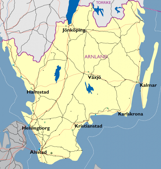
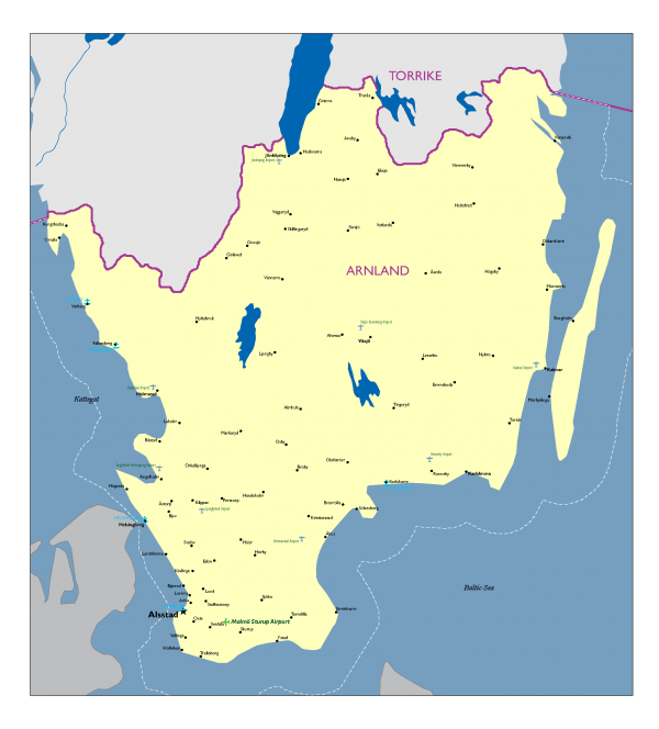
| − | Over 62% percent of Arnland's people live in urban areas. Arnland has 8 metropolitan areas with populations over 25,000 residents. | + | [[File:Arnland Cities 2.png|alt=Major Cities in Arnland|left|thumb|576x576px|Major Cities in Arnland]] |
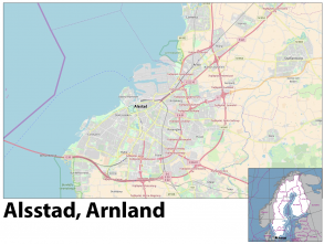
| + | Arnland's population is most dense along the coastline, rivers and tributaries. The inland border with Torrike is sparsely populated with towns tied to the road network crossing the border into and from Torrike. The infrastructure established during the Skolkan period largely remains in place with varying levels of maintenance and repair. City centers predominantly consist of older construction while the surrounding urban areas have slightly more modern buildings, roads, and utilities. Over 62% percent of Arnland's people live in urban areas. Arnland has 8 metropolitan areas with populations over 25,000 residents. The largest are: [[File:DATE Europe (Capital Cities) Alsstad.png|thumb|293x293px]]'''Alsstad (population 322,574 - density 2028/km<sup>2</sup>)''' | ||
| + | |||
| + | As the capital of Arnland, Alsstad is the largest and most modern city in the country. Situated on the southwestern coastline of the country, it is a gamma world city, and was one of the earliest industrialized cities in the region. In the post-industrial period, Alsstad struggles to remain current and relevant in the region. Several cities in other GBCC member countries have supplanted it as a hub of modern industrial activity because of the government's failure to keep pace with modern technology. Urbanization is high due to the limited size of the city center compared to the population density. Overall the metropolitan area boasts a population over 700,000. | ||
| + | |||
| + | '''Halmstad (population 68,085 - density 1,865/km<sup>2</sup>)''' | ||
| + | |||
| + | The city straddles the Nissan river with only three main bridges providing bank to bank access. Bridges from North to South; Frennarpsvagen, Wrangelsgatan, and Slottsbron are the main thoroughfares in the city. Smaller footbridges do cross the river but are engineered for only light vehicles, bicycles, and pedestrian traffic. The city's population does use light watercraft for recreation, residences, and light commercial traffic. A small shipping port operates at the mouth of the river with limited capability for transshipment of cargo. Urban building density is relatively low with larger apartment style complexes providing the majority of the housing. Public transit is readily available to the population and bicycle use is the predominant means of individual travel. | ||
| + | |||
| + | '''Helsingborg (population 143,304 - density 416/km<sup>2</sup>''') | ||
| + | |||
| + | Historically, control of the city of Helsingborg was a point of contention between Denmark and Arnland. Since the city's founding in 1085 it served as a key seaport located on the Arnland side of the Oresund. It was destroyed several times in conflicts between the two countries but was finally ceded to Arnland in 1820. Of the medieval construction only the original city tower survives to modern times with continuous modernization programs during the period of the Skolkan empire ensuring the infrastructure kept pace with the rest of the world. Since the breakup of the Skolkan empire modernization programs dwindled and much of the city has fallen into disrepair. As a shipbuilding center much of the industrial capacity remains but requires modernization to remain competitive in today's environment. | ||
| + | |||
{| class="wikitable" | {| class="wikitable" | ||
|+Major Cities and Sub-variable Descriptions | |+Major Cities and Sub-variable Descriptions | ||
| Line 122: | Line 134: | ||
|} | |} | ||
''<small>Legend (per TC-7-101): (UBD) urbanized building density, (L) low, (M) medium, (H) high, (P) primitive, (M) moderate, (C) complex, (NE) non-existent, (Dg) degraded, (Dv) developed</small>'' | ''<small>Legend (per TC-7-101): (UBD) urbanized building density, (L) low, (M) medium, (H) high, (P) primitive, (M) moderate, (C) complex, (NE) non-existent, (Dg) degraded, (Dv) developed</small>'' | ||
| − | |||
| − | |||
| − | |||
| − | |||
| − | |||
| − | |||
| − | |||
| − | |||
| − | |||
| − | |||
| − | |||
| − | |||
| − | |||
| − | |||
==Military Facilities== | ==Military Facilities== | ||
| Line 165: | Line 163: | ||
{| class="wikitable" | {| class="wikitable" | ||
|+Nuclear Power Stations in Arnland | |+Nuclear Power Stations in Arnland | ||
| − | |Name | + | |'''Name''' |
| − | |Location | + | |'''Location''' |
| − | |Type | + | |'''Type''' |
| − | |Capacity | + | |'''Capacity''' |
| − | |Operational | + | |'''Operational''' |
|- | |- | ||
|Barsebäck 1 | |Barsebäck 1 | ||
| Line 230: | Line 228: | ||
{| class="wikitable" | {| class="wikitable" | ||
|+Fossil Fuel Power Stations in Arnland | |+Fossil Fuel Power Stations in Arnland | ||
| − | |Name | + | |'''Name''' |
| − | |Location | + | |'''Location''' |
| − | |Type | + | |'''Type''' |
| − | |Capacity | + | |'''Capacity''' |
| − | |Operational | + | |'''Operational''' |
|- | |- | ||
|Stärnö Power Station | |Stärnö Power Station | ||
| Line 255: | Line 253: | ||
{| class="wikitable" | {| class="wikitable" | ||
|+Major Wind Power Generation Farms in Arnland | |+Major Wind Power Generation Farms in Arnland | ||
| − | |Name | + | |'''Name''' |
| − | |Location | + | |'''Location''' |
| − | |Type | + | |'''Type''' |
| − | |Capacity | + | |'''Capacity''' |
| − | |Operational | + | |'''Operational''' |
|- | |- | ||
|Falkenberg Wind Farm | |Falkenberg Wind Farm | ||
| Line 377: | Line 375: | ||
| colspan="2" | | | colspan="2" | | ||
|- | |- | ||
| − | |National Railway | + | |'''National Railway''' |
|ARTC/ArnCargo | |ARTC/ArnCargo | ||
|- | |- | ||
| − | |Supervisor | + | |'''Supervisor''' |
|Arnland Transport Agency | |Arnland Transport Agency | ||
|- | |- | ||
| − | | colspan="2" | | + | | colspan="2" | |
|- | |- | ||
| − | | colspan="2" |System Length | + | | colspan="2" |'''System Length''' |
|- | |- | ||
| − | |Total | + | |'''Total''' |
|2,781 km | |2,781 km | ||
|- | |- | ||
| − | |Double track | + | |'''Double track''' |
|852 km | |852 km | ||
|- | |- | ||
| − | |Electrified | + | |'''Electrified''' |
|2,781 km | |2,781 km | ||
|- | |- | ||
| − | | colspan="2" |Gauge | + | | colspan="2" |'''Gauge''' |
|- | |- | ||
| − | |Main | + | |'''Main''' |
|1,435 mm (4 ft, 8.5 in) | |1,435 mm (4 ft, 8.5 in) | ||
|- | |- | ||
| − | |221 km narrow | + | |'''221 km narrow''' |
|891 mm (2 ft, 11.1 in) | |891 mm (2 ft, 11.1 in) | ||
|- | |- | ||
| − | | colspan="2" |Electrification | + | | colspan="2" |'''Electrification''' |
|- | |- | ||
| − | |Main | + | |'''Main''' |
|15 kV 16 2/3 Hz single‐phase AC | |15 kV 16 2/3 Hz single‐phase AC | ||
|} | |} | ||
| Line 420: | Line 418: | ||
| colspan="7" | | | colspan="7" | | ||
|- | |- | ||
| − | |Name | + | |'''Name''' |
| − | |Runway (m) | + | |'''Runway (m)''' |
| − | |Surface | + | |'''Surface''' |
| − | |Passengers (2017) | + | |'''Passengers (2017)''' |
| − | |PCN | + | |'''PCN''' |
| − | |Cargo | + | |'''Cargo''' |
| − | (tons, 2017) | + | '''(tons, 2017)''' |
| − | |Remarks | + | |'''Remarks''' |
|- | |- | ||
| − | |Alsstad/Sturup | + | |'''Alsstad/Sturup''' |
|2,800 x 45 | |2,800 x 45 | ||
| Line 444: | Line 442: | ||
|Cargo facilities | |Cargo facilities | ||
|- | |- | ||
| − | |Jönköping | + | |'''Jönköping''' |
|2,203 x 45 | |2,203 x 45 | ||
| Line 458: | Line 456: | ||
|Cargo facilities | |Cargo facilities | ||
|- | |- | ||
| − | |Kalmar | + | |'''Kalmar''' |
|2,322 x 46 | |2,322 x 46 | ||
| Line 472: | Line 470: | ||
| | | | ||
|- | |- | ||
| − | |Halmstad | + | |'''Halmstad''' |
|2,261 x 40 | |2,261 x 40 | ||
|Asphalt | |Asphalt | ||
| Line 480: | Line 478: | ||
| | | | ||
|- | |- | ||
| − | |Hagshult | + | |'''Hagshult''' |
|2,050 x 40 | |2,050 x 40 | ||
|Asphalt | |Asphalt | ||
| Line 488: | Line 486: | ||
|Military | |Military | ||
|- | |- | ||
| − | |Hultsfred/Vimmerby | + | |'''Hultsfred/Vimmerby''' |
|1,946 x 40 | |1,946 x 40 | ||
|Concrete | |Concrete | ||
| Line 496: | Line 494: | ||
|Private with limited service | |Private with limited service | ||
|- | |- | ||
| − | |Kristianstad | + | |'''Kristianstad''' |
|2,215 x 45 | |2,215 x 45 | ||
|Asphalt | |Asphalt | ||
| Line 504: | Line 502: | ||
| | | | ||
|- | |- | ||
| − | |Ljungbyhed | + | |'''Ljungbyhed''' |
|2,010 x 40 | |2,010 x 40 | ||
| Line 518: | Line 516: | ||
|Public/Military | |Public/Military | ||
|- | |- | ||
| − | |Ronneby | + | |'''Ronneby''' |
|2,331 x 45 | |2,331 x 45 | ||
|Asphalt | |Asphalt | ||
| Line 526: | Line 524: | ||
|Public/Military | |Public/Military | ||
|- | |- | ||
| − | |Växjö/Kronoberg | + | |'''Växjö/Kronoberg''' |
|2,103 x 45 | |2,103 x 45 | ||
|Asphalt | |Asphalt | ||
| Line 534: | Line 532: | ||
| | | | ||
|- | |- | ||
| − | |Ängelholm/Helsingborg | + | |'''Ängelholm/Helsingborg''' |
|1,944 x 46 | |1,944 x 46 | ||
|Asphalt | |Asphalt | ||
| Line 542: | Line 540: | ||
| | | | ||
|- | |- | ||
| − | |Oskarshamn | + | |'''Oskarshamn''' |
|1,500 x 30 | |1,500 x 30 | ||
|Asphalt | |Asphalt | ||
| Line 561: | Line 559: | ||
| colspan="4" | | | colspan="4" | | ||
|- | |- | ||
| − | |Name | + | |'''Name''' |
| − | |Dimensions (TLOF, FATO) | + | |'''Dimensions (TLOF, FATO)''' |
| − | |Surface | + | |'''Surface''' |
| − | |Remarks | + | |'''Remarks''' |
|- | |- | ||
| − | |Ryhov County Hospital (Jönköping) | + | |'''Ryhov County Hospital (Jönköping)''' |
|12 m, 24 m | |12 m, 24 m | ||
|Concrete/Asphalt | |Concrete/Asphalt | ||
|Ambulance and rescue flights only | |Ambulance and rescue flights only | ||
|- | |- | ||
| − | |Blekinge Hospital (Karlskrona) | + | |'''Blekinge Hospital (Karlskrona)''' |
|9 m, 24 m | |9 m, 24 m | ||
|Asphalt | |Asphalt | ||
|Ambulance and rescue flights only | |Ambulance and rescue flights only | ||
|- | |- | ||
| − | |Central Hospital (Kristianstad) | + | |'''Central Hospital (Kristianstad)''' |
|20 m, 20 m | |20 m, 20 m | ||
|Asphalt | |Asphalt | ||
|Ambulance and rescue flights only | |Ambulance and rescue flights only | ||
|- | |- | ||
| − | |Skåne University Hospital (Lund) | + | |'''Skåne University Hospital (Lund)''' |
|29.3 m, 29.3 m | |29.3 m, 29.3 m | ||
|Concrete | |Concrete | ||
| Line 594: | Line 592: | ||
{| class="wikitable" | {| class="wikitable" | ||
|+Seaports in Arnland (2017) | |+Seaports in Arnland (2017) | ||
| − | | | + | |'''Name of Port''' |
| − | + | |'''Total Traffic (ton)''' | |
| − | |Total Traffic (ton) | + | |'''Ship Calls''' |
| − | |Ship Calls | + | |'''Passengers (international)''' |
| − | |Passengers (international) | ||
|- | |- | ||
| − | |||
|Trelleborg | |Trelleborg | ||
|11,381,000 | |11,381,000 | ||
| Line 606: | Line 602: | ||
|1,696,646 | |1,696,646 | ||
|- | |- | ||
| − | |||
|Alsstad | |Alsstad | ||
|9,003,000 | |9,003,000 | ||
| Line 612: | Line 607: | ||
|156,603 | |156,603 | ||
|- | |- | ||
| − | |||
|Karlshamn | |Karlshamn | ||
|7,651,000 | |7,651,000 | ||
| Line 618: | Line 612: | ||
|110,815 | |110,815 | ||
|- | |- | ||
| − | |||
|Helsingborg | |Helsingborg | ||
|7,564,000 | |7,564,000 | ||
| Line 624: | Line 617: | ||
|10,763,267 | |10,763,267 | ||
|- | |- | ||
| − | |||
|Ystad | |Ystad | ||
|3,084,000 | |3,084,000 | ||
| Line 630: | Line 622: | ||
|1,936,622 | |1,936,622 | ||
|- | |- | ||
| − | |||
|Halmstad | |Halmstad | ||
|2,751,000 | |2,751,000 | ||
| Line 636: | Line 627: | ||
|0 | |0 | ||
|- | |- | ||
| − | |||
|Varberg | |Varberg | ||
|1,809,000 | |1,809,000 | ||
| Line 642: | Line 632: | ||
|170,332 | |170,332 | ||
|- | |- | ||
| − | |||
|Karlskrona | |Karlskrona | ||
|1,369,000 | |1,369,000 | ||
| Line 648: | Line 637: | ||
|414,944 | |414,944 | ||
|- | |- | ||
| − | |||
|Mönsterås | |Mönsterås | ||
|957,000 | |957,000 | ||
| Line 654: | Line 642: | ||
|0 | |0 | ||
|- | |- | ||
| − | |||
|Kalmar | |Kalmar | ||
|957,000 | |957,000 | ||
| Line 660: | Line 647: | ||
|2,990 | |2,990 | ||
|- | |- | ||
| − | |||
|Sölvesborg | |Sölvesborg | ||
|941,000 | |941,000 | ||
| Line 666: | Line 652: | ||
|0 | |0 | ||
|- | |- | ||
| − | |||
|Oskarshamn | |Oskarshamn | ||
|888,000 | |888,000 | ||
| Line 672: | Line 657: | ||
|249,665 | |249,665 | ||
|- | |- | ||
| − | |||
|Åhus | |Åhus | ||
|782,000 | |782,000 | ||
| Line 678: | Line 662: | ||
|0 | |0 | ||
|- | |- | ||
| − | |||
|Landskrona | |Landskrona | ||
|629,000 | |629,000 | ||
| Line 684: | Line 667: | ||
|0 | |0 | ||
|- | |- | ||
| − | |||
|Falkenberg | |Falkenberg | ||
|492,000 | |492,000 | ||
| Line 690: | Line 672: | ||
|0 | |0 | ||
|- | |- | ||
| − | |||
|Höganäs | |Höganäs | ||
|381,000 | |381,000 | ||
| Line 696: | Line 677: | ||
|0 | |0 | ||
|- | |- | ||
| − | |||
|Västervik | |Västervik | ||
|288,000 | |288,000 | ||
| Line 702: | Line 682: | ||
|0 | |0 | ||
|- | |- | ||
| − | |||
|Bergkvara | |Bergkvara | ||
|59,000 | |59,000 | ||
| Line 714: | Line 693: | ||
{| class="wikitable" | {| class="wikitable" | ||
|+Arnland International Ferry Lines | |+Arnland International Ferry Lines | ||
| − | |Name of Port | + | |'''Name of Port''' |
| − | |To/From | + | |'''To/From''' |
| − | |Frequency | + | |'''Frequency''' |
| − | |Duration | + | |'''Duration''' |
|- | |- | ||
|Helsingborg | |Helsingborg | ||
| Line 784: | Line 763: | ||
{| class="wikitable" | {| class="wikitable" | ||
|+Telecommunications Fiber Cables in Arnland | |+Telecommunications Fiber Cables in Arnland | ||
| − | | | + | |'''Name''' |
| − | + | |'''Ready for Service''' | |
| − | |Ready for Service | + | |'''Cable Length''' |
| − | |Cable Length | + | |'''Landing Points''' |
| − | |Landing Points | ||
|- | |- | ||
| − | |||
|Baltica | |Baltica | ||
|1997 | |1997 | ||
| Line 798: | Line 775: | ||
Gedser, Denmark ‐ Kolobrzeg, Poland | Gedser, Denmark ‐ Kolobrzeg, Poland | ||
|- | |- | ||
| − | |||
|Denmark‐Arnland 16 | |Denmark‐Arnland 16 | ||
|1991 | |1991 | ||
| Line 804: | Line 780: | ||
|Velling, Arnland ‐ Mosede, Denmark | |Velling, Arnland ‐ Mosede, Denmark | ||
|- | |- | ||
| − | |||
|Danica North | |Danica North | ||
|1998 | |1998 | ||
| Line 810: | Line 785: | ||
|Barsebäck, Arnland ‐ Tuborg, Denmark | |Barsebäck, Arnland ‐ Tuborg, Denmark | ||
|- | |- | ||
| − | |||
|GlobalConnect 2 (GC2) | |GlobalConnect 2 (GC2) | ||
|2001 | |2001 | ||
| Line 816: | Line 790: | ||
|Kungsbacka, Arnland ‐ Saeby, Denmark | |Kungsbacka, Arnland ‐ Saeby, Denmark | ||
|- | |- | ||
| − | |||
|Kattegat 1 | |Kattegat 1 | ||
|1995 | |1995 | ||
| Line 822: | Line 795: | ||
|Kungsbacka, Arnland ‐ Saeby, Denmark | |Kungsbacka, Arnland ‐ Saeby, Denmark | ||
|- | |- | ||
| − | |||
|Kattegat 2 | |Kattegat 2 | ||
|2001 | |2001 | ||
| Line 830: | Line 802: | ||
Lyngsa, Osterby and Vestero, Denmark | Lyngsa, Osterby and Vestero, Denmark | ||
|- | |- | ||
| − | |||
|Denmark‐Arnland 17 | |Denmark‐Arnland 17 | ||
|1994 | |1994 | ||
| Line 836: | Line 807: | ||
|Kristinelund, Arnland ‐ Alsgarde, Denmark | |Kristinelund, Arnland ‐ Alsgarde, Denmark | ||
|- | |- | ||
| − | |||
|Denmark‐Arnland 18 | |Denmark‐Arnland 18 | ||
|1996 | |1996 | ||
| Line 842: | Line 812: | ||
|Helsingborg, Arnland ‐ Helsingør, Denmark | |Helsingborg, Arnland ‐ Helsingør, Denmark | ||
|- | |- | ||
| − | |||
|Scandinavian Ring North | |Scandinavian Ring North | ||
|2000 | |2000 | ||
| Line 848: | Line 817: | ||
|Helsingborg, Arnland ‐ Helsingør, Denmark | |Helsingborg, Arnland ‐ Helsingør, Denmark | ||
|- | |- | ||
| − | |||
|Scandinavian Ring South | |Scandinavian Ring South | ||
|2000 | |2000 | ||
| Line 854: | Line 822: | ||
|Bunkeflostand, Arnland ‐ Dragor, Denmark | |Bunkeflostand, Arnland ‐ Dragor, Denmark | ||
|- | |- | ||
| − | |||
|IP-Only | |IP-Only | ||
|1994 | |1994 | ||
| Line 891: | Line 858: | ||
{| class="wikitable" | {| class="wikitable" | ||
|+Hydrocarbon Storage Facilities in Arnland | |+Hydrocarbon Storage Facilities in Arnland | ||
| − | |Name | + | |'''Name''' |
| − | |Diesel Storage Capacity | + | |'''Diesel Storage Capacity''' |
| − | |Gasoline Storage Capacity | + | |'''Gasoline Storage Capacity''' |
| − | |F35 Storage Capacity | + | |'''F35 Storage Capacity''' |
| − | |F76 Storage Capacity | + | |'''F76 Storage Capacity''' |
|- | |- | ||
| − | |Karlskrona | + | |'''Karlskrona''' |
|50,000 | |50,000 | ||
|0 | |0 | ||
| Line 903: | Line 870: | ||
|150,000 | |150,000 | ||
|- | |- | ||
| − | |Alsstad | + | |'''Alsstad''' |
|25,000 | |25,000 | ||
|30,000 | |30,000 | ||
| Line 909: | Line 876: | ||
|150,000 | |150,000 | ||
|- | |- | ||
| − | |Helsingborg | + | |'''Helsingborg''' |
|150,000 | |150,000 | ||
|150,000 | |150,000 | ||
| Line 915: | Line 882: | ||
|250,000 | |250,000 | ||
|- | |- | ||
| − | |Karslhamn | + | |'''Karslhamn''' |
|150,000 | |150,000 | ||
|150,000 | |150,000 | ||
| Line 921: | Line 888: | ||
|450,000 | |450,000 | ||
|- | |- | ||
| − | |Kalmar | + | |'''Kalmar''' |
|200,000 | |200,000 | ||
|200,000 | |200,000 | ||
| Line 927: | Line 894: | ||
|450,000 | |450,000 | ||
|- | |- | ||
| − | |Vastervik | + | |'''Vastervik''' |
|100,000 | |100,000 | ||
|100,000 | |100,000 | ||
Revision as of 19:21, 26 September 2018
DATE Europe > Arnland > Infrastructure:Arnland ←You are here
Arnland inherited a balanced transportation system (e.g., roads, rail, aviation, and merchant marine) from the Skolkan period. An integrated road and rail system serves the country. Due to an inefficient inspection program bridges on the main arteries are mainly in poor condition. Arnland has approximately 40,000 km of roads, of which about 20,000 km are paved. Because of shrinking budgets and poor standards the road conditions continue deterioration. All of the railways are standard gauge. Arnland has a merchant marine fleet of 40 ships (cargo ships, petroleum tankers, passenger cruise ships, ferries, refrigerated cargo vessels).
The military infrastructure is extensive and predominantly receives better inspection and maintenance. However, even in the military infrastructure area the overall picture is one of gradual decline. The Arnland military infrastructure approach focuses on redundancy and making the best with limited resources. The Arnish Air Force, for instance, possesses few hardened aircraft shelters, but a large number of dispersal points and bare bases/highway strips of varying capabilities.
Major Cities and Urban Zones
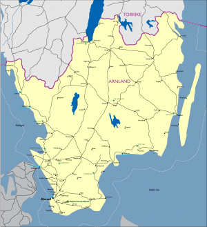
Arnland's population is most dense along the coastline, rivers and tributaries. The inland border with Torrike is sparsely populated with towns tied to the road network crossing the border into and from Torrike. The infrastructure established during the Skolkan period largely remains in place with varying levels of maintenance and repair. City centers predominantly consist of older construction while the surrounding urban areas have slightly more modern buildings, roads, and utilities. Over 62% percent of Arnland's people live in urban areas. Arnland has 8 metropolitan areas with populations over 25,000 residents. The largest are: Alsstad (population 322,574 - density 2028/km2)As the capital of Arnland, Alsstad is the largest and most modern city in the country. Situated on the southwestern coastline of the country, it is a gamma world city, and was one of the earliest industrialized cities in the region. In the post-industrial period, Alsstad struggles to remain current and relevant in the region. Several cities in other GBCC member countries have supplanted it as a hub of modern industrial activity because of the government's failure to keep pace with modern technology. Urbanization is high due to the limited size of the city center compared to the population density. Overall the metropolitan area boasts a population over 700,000.
Halmstad (population 68,085 - density 1,865/km2)
The city straddles the Nissan river with only three main bridges providing bank to bank access. Bridges from North to South; Frennarpsvagen, Wrangelsgatan, and Slottsbron are the main thoroughfares in the city. Smaller footbridges do cross the river but are engineered for only light vehicles, bicycles, and pedestrian traffic. The city's population does use light watercraft for recreation, residences, and light commercial traffic. A small shipping port operates at the mouth of the river with limited capability for transshipment of cargo. Urban building density is relatively low with larger apartment style complexes providing the majority of the housing. Public transit is readily available to the population and bicycle use is the predominant means of individual travel.
Helsingborg (population 143,304 - density 416/km2)
Historically, control of the city of Helsingborg was a point of contention between Denmark and Arnland. Since the city's founding in 1085 it served as a key seaport located on the Arnland side of the Oresund. It was destroyed several times in conflicts between the two countries but was finally ceded to Arnland in 1820. Of the medieval construction only the original city tower survives to modern times with continuous modernization programs during the period of the Skolkan empire ensuring the infrastructure kept pace with the rest of the world. Since the breakup of the Skolkan empire modernization programs dwindled and much of the city has fallen into disrepair. As a shipbuilding center much of the industrial capacity remains but requires modernization to remain competitive in today's environment.
| City | Est Pop (2017) | Pop Dens/km2 | UBD | Road | Air | Rail | Sea | Power | Water | Sanitation |
|---|---|---|---|---|---|---|---|---|---|---|
| Alsstad | 322,574 | 2,028.8 | H | C | C | C | C | C | C | C |
| Halmstad | 68,085 | 1,865.0 | L | M | M | M | M | M | M | M |
| Helsingborg | 143,304 | 416.7 | M | M | L | M | H | M | M | M |
| Jonknping | 89,780 | 68.7 | L | M | L | L | NE | L | L | L |
| Kalmar | 67,451 | 70.5 | M | M | M | M | M | M | M | M |
| Kalskrona | 66,666 | 64.0 | L | L | L | M | H | M | M | M |
| Kristianstad | 82,510 | 61.2 | L | L | L | M | NE | L | L | L |
| Vaxjn | 86,970 | 45.6 | L | M | L | L | NE | L | L | L |
Legend (per TC-7-101): (UBD) urbanized building density, (L) low, (M) medium, (H) high, (P) primitive, (M) moderate, (C) complex, (NE) non-existent, (Dg) degraded, (Dv) developed
Military Facilities
Arnland has an extensive network of facilities covering the whole spectrum of civil and military activities. The Ministry of Defence (MoD), General Staff, Central Military Clinic, Air Force HQ and the Presidential Guard are located in Alsstad; the Navy HQ is in Karlskrona and Army HQ in Jönköping. The army consists of three all‐arms brigades and six county brigades. Of the county brigades, the Skåne is located at Revingehed outside Lund, with firing ranges at Rinkaby, Ravlunda, and Kabusa. The other brigades are located in Kalmar, Eksjö (Jönköping), Karlskrona, Växjö and Halmstad. The engineers and logistic troops, as well as the EOD and Demining Center, are based in Eksjö, Jönköping. The War College and some army schools are based in Halmstad. The Arnish Navy is based at Karlskrona Naval Base. Small Navy bases are in Kalmar, Helsingborg, and Varberg. The Arnish Air Force has Ronneby Airbase in Blekinge as its main operating base, where both fighters and helicopters are stationed. The other air force bases are Hagshult, Jönköping, and Ljungbyhed, Skåne. The SDF has a brigade in each of the six counties of Arnland: Skåne, Blekinge, Kalmar, Kronoberg, Halland, and Jönköping.
Government Non-Military Facilities
Prisons
Every county has its own prisons, administered by the respective division of the Arnland Penal Services. The prisons are largely antiquated structures with little in the way of modern security systems or facilities for the prison population. Prisoners farm surrounding agricultural plots to raise much of the food that supplements their diets. There are special prisons for youth and long‐stay prisoners in Alsstad.
Coast Guard
The Arnish Coastguard HQ, including the Maritime Rescue Operations Center, is based at Karlskrona Naval Base. Additional Coast Guard stations are at Västervik, Kalmar, Simrishamn, Höllviken, Helsingborg and Falkenberg.
Medical Facilities
The main hospital in Arnland is the Skåne University Hospital in Lund and Alsstad. Other hospitals are Halland Hospital (Halmstad, Varberg, and Kungsbacka), Helsingborg Hospital, Ängelholm Hospital, Landskrona Hospital, Trelleborg Hospital, Ystad Hospital, Kalmar County Hospital , Central Hospital (Kristianstad), Oskarshamn Hospital, Västervik Hospital, Ryhov County Hospital (Jönköping), Värnamo Hospital, Blekinge Hospital (Karlskrona), and Highlands Hospital (Eksjö). The Central Military Clinic is in Alsstad. Other military hospitals are located alongside civilian hospitals in the main garrisons.
Utilities
Power
Arnland possesses a mix of hydroelectric, wind, fossil fuel and nuclear power generation plants and has moderately effective water and waste management structures. Arnland possesses no economically viable domestic sources of fossil fuel and must import substantial amounts of petroleum, natural gas and other energy resources, including uranium for nuclear power generation.
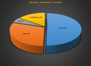
The electricity production in Arnland is dominated by nuclear power (approximately 50%), hydroelectricity (29%), and wind farms contributing approximately 6%. Fossil fuel and biomass is used mainly for reserve power and district heating contributing approximately 15%.
Nuclear
Arnland's energy market is largely privatized. The 1973 oil crisis strengthened Arnland’s commitment to decrease dependence on imported fossil fuels. Since then, electricity generation is predominately from nuclear power. Among other things, the accident of Three Mile Island Nuclear Generating Station (USA) prompted the Arnland parliament to hold a referendum on nuclear power in 1980. The referendum led to a decision that no further nuclear power plants should be built and that a nuclear power phase‐out should be completed by 2030. This decision has been reconsidered several times and currently the government looks into the possible role of nuclear energy in reducing CO2 emissions and securing energy supply. Internal bottlenecks in the Arnland electric grid restrict transmission of electricity between nuclear and wind plants. Arnland has a policy of a single system price regardless of power differences between areas. The Ministry of Economy, Trade, Industry and Energy (METIE) is responsible for energy policy. The Arnland Nuclear Energy Program (ANEP) is dealing with all nuclear power issues on behalf of the METIE. A list of the main power stations, both operational and decommissioned, is below:
| Name | Location | Type | Capacity | Operational |
| Barsebäck 1 | Barsebäckshamn, Skåne | BWR | 630 MW | Shut down, not dismantled |
| Barsebäck 2 | Barsebäckshamn, Skåne | BWR | 630 MW | Shut down, not dismantled |
| Oskarshamn 1 | Figeholm, Kalmar | BWR | 500 MW | Shut down, not dismantled |
| Oskarshamn 2 | Figeholm, Kalmar | BWR | 630 MW | Operational since 1974 |
| Oskarshamn 3 | Figeholm, Kalmar | BWR | 1,200 MW | Operational since 1985 |
| Ringhals 1 | Gloppe, Halland | BWR | 860 MW | Operational since 1976 |
| Ringhals 2 | Gloppe, Halland | PWR | 870 MW | Operational since 1975 |
| Ringhals 3 | Gloppe, Halland | PWR | 920 MW | Operational since 1981 |
| Ringhals 4 | Gloppe, Halland | PWR | 910 MW | Operational since 1983 |
(BWR – Boiling water reactor; PWR – Pressurized water reactor)
| Name | Location | Type | Capacity | Operational |
| Stärnö Power Station
(Karlshamnsverket) |
Karlshamn, Blekinge | Fuel oil | 1,020 MW (3 x 340) | Peak and reserve power station |
| Öresund Power Station (Öresundsverket) | Alsstad, Skåne | Combined Heat and Power (CHP), gas‐fired | 440 MW electricity & 250 MW heat | Operational since
2009 |
| Name | Location | Type | Capacity | Operational |
| Falkenberg Wind Farm | Falkenberg | Onshore; 15 turbines | 11 MW | Yes |
| Hedagården‐Tågarp Wind Farm | Svalöv | Onshore; 6 turbines | 9 MW | Yes |
| Landskrona Wind Farm | Landskrona | Onshore; 12 turbines | 7 MW | Yes |
| Stora Istad Wind Farm | Borgholm | Onshore; 5 turbines | 10 MW | Yes |
| Brahehus Wind Farm | Gränna | Onshore; 9 turbines | 20.7 MW | Yes |
| Lillgrund | Öresund | Offshore; 48 turbines | 110 MW | Yes |
| Utgrunden 1 | Baltic Sea | Offshore; 7 turbines | 10.5 MW | Yes |
| Yttre Stengrund | Baltic Sea | Offshore; 5 turbines | Yes | |
| Kårehamn | Baltic Sea | Offshore; 16 turbines | Yes |
Electrical Grid
The Arnish national grid comprises 400 and 220 kV lines, switchyards, transformer stations and foreign links for alternating (AC) and direct current (DC) power. The Arnish electricity system has links to Germany (600 MW), Poland (600 MW), and several links to Denmark and Torrike. This includes a 260 MW bipole HVDC link from Västervik to the Torrikan island of Gotland and a 60kV cable with a capacity of 60 MW to the Danish island of Bornholm. A submarine power cable with a capacity of 700 MW to Lithuania is planned. There are plans to replace two old 400 kV cables with Denmark, but the funding is an issue. The national grid is owned by the state of Arnland and managed by Arnish Power Company (AKN; Arnska Kraftnät), a state‐owned public utility. Electricity is transported from the national grid via county grids (40‐130 kV lines) to local grids (less than 40 kV) and finally to the consumers.
Natural Gas
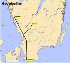
Arnland has a limited natural gas infrastructure. The network stretches from Trelleborg in the south along the west coast into Torrike, with a branch line to Gnosjö at the Torrikan border. The transmission system, the main pipeline including the Torrikan part, is 620 kilometers long and the distribution system is 2,600 kilometers long. All pipes on land are laid underground. The gas is mainly used by households, industries and district heating companies. In those municipalities where the natural gas network is present, it covers around 20 percent of the final energy consumption. It is primarily natural gas from Denmark that is transported through the network. The transmission network is owned by the company ArnGas.
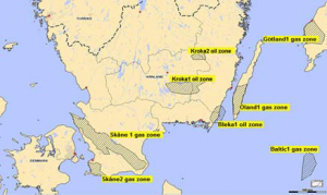
In 2014, the Arnish government issued licenses for gas exploration drillings. The Torrikan company Draken Gas AB gets 185 km2 of exploration area on and near Öland (on‐and offshore) and the state‐owned ArnGas gets 1,036 km2 in Skåne. The exploration is under process but no result is present yet.
In 2015, the state owned company ArnGas published its economic report and a feasibility study for the extension of its own gas network. The study proposes the extending of the gas network in two phases during the next four years. The first phase addresses the extending of transmission lines by 48 km and upgrading/extending the gas distribution system by 357 km. The second phase addresses the extension of the transmission lines by an additional 92 km and extending the gas distribution system to total of 3,850 km, with the goal of increasing the final energy consumption from 20% to 37%. The shortfall of government funds is forcing ArnGas to seek private investors interested in providing the invest of nearly € 67 million on this project.
District Heating
District heating is the most common form of heating for blocks and commercial premises in Arnland. It is water that is heated in a thermal power station and then transmitted via a pipeline system to the heaters and hot water taps in a property. Most of these power stations are small size and owned by the municipality. Eighty percent of residential heating in Arnland comes from district heating.
Water
Until the mid-2010s, Arnland had an efficient wastewater treatment capability, good drinking water quality, low water charges and a reliable supply. In Arnland, water supply and sewage disposal are by law a municipal responsibility. Under municipal control and with financial support from the state, intensive construction of treatment plants was carried out during the 1960s and 1970s. Wastewater treatment was comprehensive until 2015 with 98% of the wastewater treated both biologically and chemically and as much as 58 percent also being treated using a special nitrogen removal process. Lack of funding from that point forward caused poor maintenance and little renewal or construction of new treatment infrastructure. Water supply and sewage disposal infrastructure for municipal use encompasses more than 9,000 water works, 20,000 employees, but a growing decline in potable water production and waste water treatment.
Waste Management
Almost 3.5 million tons of waste were generated in Arnland in 2017. Just short of 2.7 million tons of municipal waste were collected, under half of it generated by households. Altogether 1.28 million tons municipal waste were land filled. Arnland waste legislation covers all types of waste except certain special wastes such as radioactive wastes, which are controlled by separate laws.
- The Ministry of Environment supervises and controls the way Arnland waste legislation is put into practice.
- The Arnish Environmental Protection Agency (Naturvårdsverket) conducts research and training, publicizes new ideas and methods, and monitors all developments related to waste issues, while also participating in drawing up new legislation and guidelines related to waste. The agency also monitors international waste shipments.
- County environment centers guide, encourage and monitor the implementation of the Waste Act in their own areas. They also provide training and advice for firms and the public, and issue waste permits to larger firms and operations.
- Local authorities organize the collection, recovery and disposal of household refuse and other similar waste, and supervise waste management in general in their own area. They also set local regulations on waste management, ensure that advice on waste matters is freely available, and issue waste permits to smaller firms and operations.
- Arnland has a well‐developed nuclear waste management policy. Low‐level waste is currently stored at Barsebäck. This facility has been constructed as a permanent underground repository with a capacity of 50,000 cubic meters for low‐level waste. All intermediate and high‐level radioactive waste and spent nuclear fuel is shipped to Bothnia for storage at the depository at the Olkiluoto deep‐level repository.
Transportation Architecture
The Ministry of Public Works, Transport, Telecommunications and IT (MPWTTIT) is responsible for transportation issues. Arnland possesses an extensive transportation network comprising national and county road, rail, air and waterway networks. The maintenance of these networks is, in theory, tightly controlled by national and county bodies. This has been an increasingly difficult task due to Arnland’s depressed economy, increasing corruption and organized criminal activity, which has led to transportation funds being squandered. Upgrading of the transport network is one of the biggest challenges for Arnland government and one of the most economically beneficial projects.
Road System
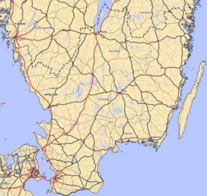
Arnland possesses an extensive road network that provides good communication routes throughout the country. The most rapid development of the length and density of the public road network took place in the 20th century. However, during the past decade, investments in the road network have dramatically declined and the road conditions have deteriorated. Motorways run through Arnland and Denmark and over the Öresund Link to Tyr, Göteborg, Uppsala, and Uddevalla in Torrike. The system of motorways is still under construction. The main road network, which includes highways, primary and secondary roads, totals 19,630 km.
In 2016, there were approximately 1.7 million registered cars, 154,000 trucks, 4,500 buses and 37,000 motorcycles. Arnland has had right‐hand traffic since 1967. The current basic speed limit is 70 kilometers per hour. In built‐up areas, the normal speed limit is 50 kph, but 30 kph is becoming more common in places where pedestrians and cyclists mix with vehicle traffic. On highways of a good standard, the typical speed limit is 90 kph, and on freeways (motorways) it is usually 110 kph. The public road network in Arnland is divided into three weight classes: Class 1 (BK1), Class 2 (BK2) and Class 3 (BK3). The highest weights are permitted on the BK1 road network, whose weight regulations apply on some 94% of the public road network. Exceptional transports within Arnland require an exemption (permit) from the Arnland Transport Agency (Trafikverket).
There are two large bridges in Arnland. The first is the Öresund Bridge (Öresundsbron), connecting Arnland with Denmark. The other one is the Öland Bridge (Ölandsbron), a road bridge connecting Kalmar on the mainland to Färjestaden on the island of Öland. At 6,072 m long, it is one of the longest in all of Europe. It is supported by 156 pillars, and has a characteristic hump at its western end which was created to provide a vertical clearance of 36 m for shipping. While the Öresund Bridge linking Arnland with Denmark is longer overall, the Öland Bridge is the longest entirely in Arnish territory. The bridge was inaugurated in September 1972. Construction took 4.5 years, and about 100,000 cubic meters of concrete was used. The bridge was also constructed to transport fresh water from the mainland to Öland.
Rail
Rail transport in Arnland, Framland, and Torrike uses a combined total network of approximately 12,000 km of track. The total length of track in Arnland is 2,781 km. Construction of the first railway line in what is now Arnland, Framland, and Torrike began in 1855 expanding from two major cities, Tyr and Göteborg. The main line railways were of major importance for the development of the Skolkan industry. The first two main line railways were the Southern, stretching from Tyr to Alsstad in the south, and the Western, to Göteborg in the west. These railway lines were finished in 1864. The Northern railway runs parallel to the Baltic coast (but not along it) to Boden in Framland. It was a part of the 1853 decision that the railways should avoid coasts, and not make detours to pass medium size cities along the route. The principle was that the main lines were built by the state, but all others by private companies, often owned by cities to support their local need. In the period 1930‐1950 most lines were purchased by the state.
The primary rail operator for passengers is Arnland Rail Transportation Company (ARTC), which is state owned and operated. For cargo the main operator is the state‐owned company ArnCargo. There are also a number of private rail operators that provide serves on the commercially viable passenger and freight routes within Arnland. Rail traffic is supervised by the Arnland Transport Agency. The main lines are double track. Around 80% of the railways are electrified. All tracks are standard gauge, except one narrow gauge railway, a so‐called Arnish Three Foot Gauge Railway. It is the line between Åseda, Hultsfred, and Västervik. Of this, 70 km between Hultsfred and Västervik, as well as the shorter sections between Virserum‐Hjortöström and Åseda‐Hultanäs, are served by tourist trains in the summer.
There are railway links with adjacent countries:
- Denmark ‐ Öresund bridge/tunnel ‐ same gauge ‐ voltage change 15kV AC/25kV AC.
- Germany ‐ Train ferries Alsstad ‐ Travemünde, Trelleborg ‐ Sassnitz and Trelleborg – Rostock ‐ same gauge ‐ no electric propulsion on board.
- Torrike ‐ same gauge ‐ same voltage.
- Poland ‐ Train ferry Ystad ‐ Świnoujście ‐ same gauge ‐ no electric propulsion on board. Arnland, Framland, and Torrike have the same Automatic Train Control (ATC) system and the same voltage, meaning that trains can generally cross the borders without being specially modified. Arnland and Denmark have different ATC systems and different voltage, so only specially modified trains can cross the border. The Öresund trains (X31) and some of the X2000 trains can do that. Train ferries never have electric overhead lines on board, so diesel must be used to get trains on board/off board. Generally locomotives are not transported on these ferries, only train cars.
| National Railway | ARTC/ArnCargo |
| Supervisor | Arnland Transport Agency |
| System Length | |
| Total | 2,781 km |
| Double track | 852 km |
| Electrified | 2,781 km |
| Gauge | |
| Main | 1,435 mm (4 ft, 8.5 in) |
| 221 km narrow | 891 mm (2 ft, 11.1 in) |
| Electrification | |
| Main | 15 kV 16 2/3 Hz single‐phase AC |
Air Transportation System
Airports
The international passenger gateway to Arnland is through Alsstad Sturup International Airport (ASIA). It is the largest airport (2.1 million passengers in 2017) and is located 15 km north of Alsstad. In addition, Arnland possesses numerous airstrips that date back to WWII, that are usually built into roads and are less than 1000 m long. Seven airports have scheduled passenger services and all airports are financed by the state. Rural airports tend to be subsidized. The Alsstad based ArnAir and Arncomm Airlines provide air services both domestically and internationally. The larger airports are managed by the state‐owned ArnAvia (formerly the Arnland Civil Aviation Administration), while the smaller ones are usually managed by municipal authorities. ArnAir and Arncomm Airlines are the main carriers for domestic flights. Alsstad airport is Arnland's global gateway with scheduled non‐stop flights to such places as North America, Europe, Olvana, and various African countries. There are two airports with cargo facilities: Alsstad and Jönköping. A lot of cargo is also coming through Göteborg‐Landvetter airport in Torrike. A summary of airports in Arnland is listed in the table below:
| Name | Runway (m) | Surface | Passengers (2017) | PCN | Cargo
(tons, 2017) |
Remarks |
| Alsstad/Sturup | 2,800 x 45
800 x 23 |
Asphalt
Asphalt |
2,104,359 | 80
15 |
27,571 | Cargo facilities |
| Jönköping | 2,203 x 45
600 x 25 |
Asphalt
Graded Earth |
77,670 | 55
N/A |
5,323 | Cargo facilities |
| Kalmar | 2,322 x 46
1308 x 41 |
Asphalt
Asphalt |
185,530 | 50
30 |
N/A | |
| Halmstad | 2,261 x 40 | Asphalt | 95,655 | 45 | N/A | |
| Hagshult | 2,050 x 40 | Asphalt | N/A | XX | N/A | Military |
| Hultsfred/Vimmerby | 1,946 x 40 | Concrete | N/A | 30 | N/A | Private with limited service |
| Kristianstad | 2,215 x 45 | Asphalt | N/A | 45 | N/A | |
| Ljungbyhed | 2,010 x 40
2,270 x 40 |
Asphalt
Asphalt |
N/A | 25
25 |
N/A | Public/Military |
| Ronneby | 2,331 x 45 | Asphalt | 218,965 | 50 | N/A | Public/Military |
| Växjö/Kronoberg | 2,103 x 45 | Asphalt | 194,350 | 40 | N/A | |
| Ängelholm/Helsingborg | 1,944 x 46 | Asphalt | 404,434 | 45 | N/A | |
| Oskarshamn | 1,500 x 30 | Asphalt | N/A | 15 | N/A | No control tower |
| All airports have a control tower, ground handling services and fuel facilities. | ||||||
Heliports
Heliports as defined in ICAO (International Civil Aviation Organization) Annex 15 AD 3 are not established in Arnland. Helicopter operations normally take place on aerodromes. Below is a list of licensed heliports in Arnland. Heliport lighting normally consists of a circle or square of inset lights around the surface called the TLOF (touchdown and lift‐off area) and another around the overall landing area called the FATO (final approach and take‐off area). The later encompasses the TLOF as well and the lights may be elevated or inset.
| Name | Dimensions (TLOF, FATO) | Surface | Remarks |
| Ryhov County Hospital (Jönköping) | 12 m, 24 m | Concrete/Asphalt | Ambulance and rescue flights only |
| Blekinge Hospital (Karlskrona) | 9 m, 24 m | Asphalt | Ambulance and rescue flights only |
| Central Hospital (Kristianstad) | 20 m, 20 m | Asphalt | Ambulance and rescue flights only |
| Skåne University Hospital (Lund) | 29.3 m, 29.3 m | Concrete | Ambulance and rescue flights only |
Ports/Sea/River Transportation System
Sea ports
Until the mid‐1960s, Arnland had limited shipbuilding capacity and few oceangoing vessels. After 1962, however, shipbuilding and harbor construction mushroomed as the government invested heavily in those industries with the reconstruction of the ports of Trelleborg, Alsstad, Karlshamn, and Helsingborg. By the 1970s, Alsstad, which had received the highest funding priority, ranked highly among GBCC sea ports. In 1991, flag vessels in the Arnland ocean going merchant fleet numbered 58 for a total of almost 600,000 deadweight tons, which decreased to a number of 40 vessels in 2017. Arnland hosts one of the largest port companies in Scandinavia, the transnational company Alsstad Port AB. The nation's largest seaport of Trelleborg is undergoing expansion and renovation projects. There is passenger traffic from all ports to mainland Europe and the other GBCC countries. The other main ports in Arnland include Halmstad, Karlskrona, Ystad, and Varberg. The port of Göteborg in Torrike is also important for the transport of bulk cargo and containers.
| Name of Port | Total Traffic (ton) | Ship Calls | Passengers (international) |
| Trelleborg | 11,381,000 | 5,526 | 1,696,646 |
| Alsstad | 9,003,000 | 2,793 | 156,603 |
| Karlshamn | 7,651,000 | 2,025 | 110,815 |
| Helsingborg | 7,564,000 | 45,012 | 10,763,267 |
| Ystad | 3,084,000 | 3,379 | 1,936,622 |
| Halmstad | 2,751,000 | 1,148 | 0 |
| Varberg | 1,809,000 | 1,241 | 170,332 |
| Karlskrona | 1,369,000 | 708 | 414,944 |
| Mönsterås | 957,000 | 343 | 0 |
| Kalmar | 957,000 | 397 | 2,990 |
| Sölvesborg | 941,000 | 437 | 0 |
| Oskarshamn | 888,000 | 673 | 249,665 |
| Åhus | 782,000 | 355 | 0 |
| Landskrona | 629,000 | 329 | 0 |
| Falkenberg | 492,000 | 267 | 0 |
| Höganäs | 381,000 | 108 | 0 |
| Västervik | 288,000 | 93 | 0 |
| Bergkvara | 59,000 | 24 | 0 |
Waterways
There are frequent ferry services that connect Arnland with Germany, Torrike, Lithuania, Poland, and Denmark. Baltic cruise liners regularly call on the port of Alsstad as well. During the summer there are two ferries between the mainland and the island Öland: Oskarshamn – Byxelkrok (two hours) and Kalmar – Färjestaden (bicycle ferry, 30 minutes). On Lake Vättern, there is a ferry between Gränna and the island of Visingsö. Arnland's cargo ports move freight both for Arnland's own needs and for transhipment. The Arnland Maritime Administration (Sjöfartsverket), is responsible for the maintenance of Arnland's waterway network. Arnland shares an extensive coastal and inland network of waterways with Torrike. The total length of navigable waterways in Arnland and Torrike is 2,052 km.
| Name of Port | To/From | Frequency | Duration |
| Helsingborg | Denmark: Helsingør | 71/day, every 15 min | 1 hr 20 mins |
| Trelleborg | Germany:
Rostock Travemünde Sassnitz |
||
| 6/day
4/day 4/day |
6 hrs
8 hrs 4 hrs | ||
| Karlshamn | Lithuania: Klaipeda | 7/week | 14 hrs |
| Ystad | Denmark: Bornholm
Poland: Świnoujście |
10/day
4/day |
1 hr 20 mins
7 hrs |
| Oskarshamn | Torrike: Visby | 2/day | 3 hrs |
| Varberg | Denmark: Grenaa | 2/day | 4 hrs 20 mins |
| Karlskrona | Poland: Gdynia | 2/day | 10 hrs 30 mins |
Telecommunications Architecture
In the mid‐1990s, Arnland possessed a moderately well‐developed communications system. The infrastructure to support the command/control/communications/intelligence (C3I) required to run the country in war and peace is complex and often buried. The use of underground facilities, pipelines, alternate links and other structures to ensure a fully redundant system has been developed by the Arnland government since 1948. Today there are six national radio stations and four terrestrial television broadcast channels. The core fixed communications is now largely fiber‐based. Arnland is well connected to the worldwide internet backbone with a capacity up to 10 Gbit/s. Apart from the Öresund Dark Fiber Link there are a number of undersea data cables connecting Arnland to Denmark and Poland.
| Name | Ready for Service | Cable Length | Landing Points |
| Baltica | 1997 | 437 km | Ystad, Arnland ‐ Pedersker (Bornholm) –
Gedser, Denmark ‐ Kolobrzeg, Poland |
| Denmark‐Arnland 16 | 1991 | 15 km | Velling, Arnland ‐ Mosede, Denmark |
| Danica North | 1998 | 25 km | Barsebäck, Arnland ‐ Tuborg, Denmark |
| GlobalConnect 2 (GC2) | 2001 | 95 km | Kungsbacka, Arnland ‐ Saeby, Denmark |
| Kattegat 1 | 1995 | 180 km | Kungsbacka, Arnland ‐ Saeby, Denmark |
| Kattegat 2 | 2001 | 75 km | Skalvik, Arnland ‐
Lyngsa, Osterby and Vestero, Denmark |
| Denmark‐Arnland 17 | 1994 | 11 km | Kristinelund, Arnland ‐ Alsgarde, Denmark |
| Denmark‐Arnland 18 | 1996 | N/A | Helsingborg, Arnland ‐ Helsingør, Denmark |
| Scandinavian Ring North | 2000 | 5 km | Helsingborg, Arnland ‐ Helsingør, Denmark |
| Scandinavian Ring South | 2000 | 21 km | Bunkeflostand, Arnland ‐ Dragor, Denmark |
| IP-Only | 1994 | N/A | Klagshamn, Arnland ‐ Brondby, Denmark |
Agriculture
Arnland infrastructure of note is the substantial network of grain storage facilities collocated at the main shipping ports on the coast.
Industry
Arnland is a relatively resource‐poor and small politico‐economic entity. The Arnland industrial infrastructure reflects this status. The country has some mineral deposits and oil exploration is ongoing in three areas. Promising results are expected from natural gas drilling performed in Skåne County by ArnGas. Arnland’s most important minerals are iron ore, copper, lead, zinc, uranium, and limestone, but many large mines have closed down and most raw materials are now imported.
Manufacturing
From the 1990s, Arnland industry, which for centuries had relied on the country's vast forests, became dominated by to a larger extent by electronics and services, as globalization lead to a decline of more traditional industries. Outsourcing resulted in more manufacturing being transferred abroad, with Arnland-based industry focusing to a greater extent on R&D and high‐tech electronics. Arnland manufacturing capability can be divided into three sectors:
Electronics. The Arnish electronics and electro-technics industry relies on heavy investment in R&D, and has been accelerated by the liberalization of global markets. Electrical engineering started in the late 19th century. Arnish companies have enjoyed moderate success in areas such as industrial automation, telecommunication, and electronics.
Metals, Engineering and Manufacturing. Arnland has some mineral deposits, but many mines have closed down, and most raw materials are now imported. For this reason, companies now tend to focus on high added‐value processing of metals and other products. The exports include the production steel, copper, zinc and nickel, and finished products such as roofing and cladding, welded steel pipes, chainsaws, lawn mowers, sewing machines, motorcycles, copper pipe and coated sheets. The manufacturing industry is a significant employer of about 41% of the labor force.
Timber, Furniture, Pulp and Paper Industry. Forest products have been the major export industry in the past, but this share has shrunk. Pulp and paper is still a moderately large industry with 12 sites across the country. Arnland is also well‐known for producing timber and cheap DIY wooden furniture with funny names.
Oil and Gas
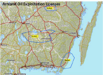
The exploration era for oil and gas deposits in Arnland started in 1975, stopped in 1979 and resumed in 2002. Three fields are identified, two in Kronoberg/Kalmar and one that extends from Blekinge, through Kalmar into the Baltic Sea, estimating that the initial production will commence in 2016. In 2005, the Government of Arnland issues an Invitation to Tender for proposals to explore the identified Arnish shale oil fields. The exploration licenses for oil fields designated as: Kroka1, Kroka2 and Bleka1 awarded on 2006 as follow:
- License for KroKa1 awarded to the Arnish Shale Oil (ASO) consortium
- License for KroKa2 awarded to the Arnish Shale Oil (ASO) consortium
- License to BleKa1 awarded to the Offshore Baltic Oil (OBO) consortium
Arnland is an importer of petroleum products and actually possesses no refining capability. Most oil products come from refineries in Göteborg and Lysekil in Torrike. Due to Arnlands small market and sparse population, the oil distribution infrastructure relies on road distribution rather than pipelines. Road tankers carry out secondary distribution to consumers and retail outlets. There is a Lined Rock Cavern (LRC) natural gas storage site near Halmstad with an annual working capacity of 8,800,000 m3.
| Name | Diesel Storage Capacity | Gasoline Storage Capacity | F35 Storage Capacity | F76 Storage Capacity |
| Karlskrona | 50,000 | 0 | 150,000 | 150,000 |
| Alsstad | 25,000 | 30,000 | 150,000 | 150,000 |
| Helsingborg | 150,000 | 150,000 | 250,000 | 250,000 |
| Karslhamn | 150,000 | 150,000 | 250,000 | 450,000 |
| Kalmar | 200,000 | 200,000 | 250,000 | 450,000 |
| Vastervik | 100,000 | 100,000 | 200,000 | 200,000 |
In 2010, initial construction work started on the shale oil extraction zone KroKa1. In 2013, the Ministry of Economy, Trade, Industry and Energy (METIE) accepted the construction project for a new oil refinery in Kalmar and new oil pipeline running from KroKa1 oil field to oil refinery. A proposal for construction of two new oil storage facilities in Karlmar and Karlshamn is still in discussion.
The main figures of the project :
- Estimated capital investment for all facilities: US 4.846 billion.
- Estimated oil volume (total reserves in the three shale oil fields): 1,370 million barrels (MMbbl)
- Estimated quantity of refined products per year 67,817,000 bbl.
- Estimated year for starting of production: 2017.
- Estimated years of production: 20 years.
- The first year expected of return on investment: 2022
- First expected year of profit: 2025 (with average global oil prices above US $ 35 a barrel) Based on the infrastructure report of METIE published in August of 2015, the progress of construction works stands as follow: New Refinery 65% and New Pipeline 42%.
| DATE Europe Quick Links . | |
|---|---|
| Arnland | Political • Military • Economic • Social • Information • Infrastructure • Physical Environment • Time |
| Bothnia | Political • Military • Economic • Social • Information • Infrastructure • Physical Environment • Time |
| Donovia-West | Political • Military • Economic • Social • Information • Infrastructure • Physical Environment • Time |
| Framland | Political • Military • Economic • Social • Information • Infrastructure • Physical Environment • Time |
| Otso | Political • Military • Economic • Social • Information • Infrastructure • Physical Environment • Time |
| Pirtuni | Political • Military • Economic • Social • Information • Infrastructure • Physical Environment • Time |
| Torrike | Political • Military • Economic • Social • Information • Infrastructure • Physical Environment • Time |
| Other | Non-State Threat Actors and Conditions • DATE Map References • Using the DATE |

