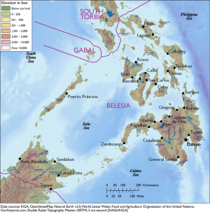
Physical Environment: Belesia
From WEG MediaWiki
Revision as of 15:35, 30 April 2018 by Deatrick.laura (talk | contribs)$7
DATE Pacific > Belesia > Physical Environment: Belesia ←You are here
To be published
Contents
Table of Physical Environment Data
| Measure | Data | Remarks |
| Land Area (sq miles) | 99,926 | Includes inland water |
| Land Border (miles) | 111 | South Torbia (23) |
| Coastline (miles) | 20,296 | |
| Highest Elevation (ft) | 13,274 | Mount Kinabalu |
| Lowest Elevation (ft) | 0 | Sea Level |
| Arable (cultivated) Land (%) | ||
| Permanent Crops (%) | ||
| Permanent Pasture (%) | ||
| Irrigated Land (%) | ||
| Forested Land (%) | ||
| Urban Area (%) |
Terrain
To be published
Bodies of Water
To be published
Mobility Classification
To be published
Natural Hazards
To be published
Subterranean Environment
To be published
Vegetation
To be published
Agriculture
To be published
Livestock and Wildlife
To be published
Climate and Weather
To be published
Seasons
Precipitation
To be published
Temperature-Heat Index
To be published
Temperature-Wind Chill Index
To be published
Relative Humidity
To be published
Wind
To be published
Visibility
To be published
Summary
To be published
| DATE Pacific Quick Links . | |
|---|---|
| Belesia | Political • Military • Economic • Social • Information • Infrastructure • Physical Environment • Time |
| Gabal | Political • Military • Economic • Social • Information • Infrastructure • Physical Environment • Time |
| North Torbia | Political • Military • Economic • Social • Information • Infrastructure • Physical Environment • Time |
| Olvana | Political • Military • Economic • Social • Information • Infrastructure • Physical Environment • Time |
| South Torbia | Political • Military • Economic • Social • Information • Infrastructure • Physical Environment • Time |
| Other | Non-State Threat Actors and Conditions |

