Difference between revisions of "Physical Environment: Ziwa"
Allen.brian (talk | contribs) m (→Border Disputes) (Tag: Visual edit) |
Allen.brian (talk | contribs) m (→Terrain) (Tag: Visual edit) |
||
| Line 66: | Line 66: | ||
== Terrain == | == Terrain == | ||
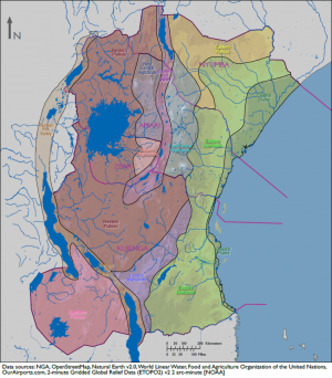
[[File:DATE Africa terrain regions map.PNG|thumb|DATE Africa Terrain Regions]] | [[File:DATE Africa terrain regions map.PNG|thumb|DATE Africa Terrain Regions]] | ||
| − | Most of Ziwa sits at the center of the East Africa's Western Plateau, which is mostly savanah extending south of Lake Victoria. The Eastern Highlands make up Ziwa's eastern border with Amari and is home to the Olduvai Gorge and Ngorogoro Crater, historical anthropological and wildlife sites. The border lakes, | + | Most of Ziwa sits at the center of the East Africa's Western Plateau, which is mostly savanah extending south of Lake Victoria. The Eastern Highlands make up Ziwa's eastern border with Amari and is home to the Olduvai Gorge and Ngorogoro Crater, historical anthropological and wildlife sites. The border lakes, Eyasi and Natron, form the southern portion of East Africa's Eastern Rift Valley, extending northward through Amari and into Nyumba's Lake Turkana. |
== Border Disputes == | == Border Disputes == | ||
| Line 72: | Line 72: | ||
== Bodies of Water == | == Bodies of Water == | ||
| − | + | Lake Victoria comprises the northwest corner of Ziwa which it shares with Amari and Kujenga. It is the largest tropical freshwater lake in the world. Over half a million Ziwans live on the lake's large islands. Lakes Eyasi and Natron, by contrast, are shallow salt-water lakes with extreme seasonal variance in water levels. No significant rivers flow through Ziwa. The Mbalangeti River flows from the Eastern Highlands into Lake Victoria's Speke Gulf, 100 km northeast of Mwanza. Even smaller rivers flow into Ziwa's two other gulfs on the southern shore Lake Victoria. Major wetlands and swamps characterize all of these river-lake boundary zones. | |
== Mobility Classification == | == Mobility Classification == | ||
Revision as of 15:25, 7 June 2018
DATE Africa > Ziwa > Physical Environment: Ziwa ←You are here
Ziwa is a relatively small country located in central Africa. It is a completely landlocked country that encompasses a portion of Lake Victoria, Lake Natron, and Lake Eyasi. The country’s terrain varies from significant a rift valley and lakes in East. Arid desert lowlands and open savannah comprise a majority of the country. Climates range from semiarid and in the west, warm desert and arid climate with increased humidity near Lake Victoria.
Contents
Table of Physical Environment Data
| Measure | Data | Remarks |
| Total Area (sq miles) | 43,116 | Includes inland water |
| Land Area (sq miles) | 34,216 | Excludes inland water |
| Inland Water (sq miles) | 8,900 | Includes Lake Victoria |
| Inland Border (miles) | 924 | Amari (437), Kujunga (437) |
| Coastline (miles) | 884 | Lake Victoria (884) |
| Highest Elevation (ft) | 10,613 | Jaeger Summit |
| Lowest Elevation (ft) | 1,913 | Lake Natron |
| Arable (cultivated) Land (%) | ||
| Permanent Crops (%) | ||
| Permanent Pasture (%) | ||
| Irrigated Land (%) | ||
| Forested Land (%) | ||
| Urban Area (%) |
Terrain
Most of Ziwa sits at the center of the East Africa's Western Plateau, which is mostly savanah extending south of Lake Victoria. The Eastern Highlands make up Ziwa's eastern border with Amari and is home to the Olduvai Gorge and Ngorogoro Crater, historical anthropological and wildlife sites. The border lakes, Eyasi and Natron, form the southern portion of East Africa's Eastern Rift Valley, extending northward through Amari and into Nyumba's Lake Turkana.
Border Disputes
Ziwa is on good terms with both Amari and Kujenga with respect to border agreements. However, the southern and western borders with Kujenga are extremely remote and rarely patrolled by either country.
Bodies of Water
Lake Victoria comprises the northwest corner of Ziwa which it shares with Amari and Kujenga. It is the largest tropical freshwater lake in the world. Over half a million Ziwans live on the lake's large islands. Lakes Eyasi and Natron, by contrast, are shallow salt-water lakes with extreme seasonal variance in water levels. No significant rivers flow through Ziwa. The Mbalangeti River flows from the Eastern Highlands into Lake Victoria's Speke Gulf, 100 km northeast of Mwanza. Even smaller rivers flow into Ziwa's two other gulfs on the southern shore Lake Victoria. Major wetlands and swamps characterize all of these river-lake boundary zones.
Mobility Classification
To be published
Natural Hazards
To be published
Subterranean Environment
To be published
Vegetation
To be published
Agriculture
To be published
Livestock and Wildlife
To be published
Climate and Weather
To be published
Seasons
To be published
Precipitation
To be published
Temperature-Heat Index
To be published
Temperature-Wind Chill Index
To be published
Relative Humidity
To be published
Wind
To be published
Summary
To be published
| DATE Africa Quick Links . | |
|---|---|
| Amari | Political • Military • Economic • Social • Information • Infrastructure • Physical Environment • Time |
| Kujenga | Political • Military • Economic • Social • Information • Infrastructure • Physical Environment • Time |
| Nyumba | Political • Military • Economic • Social • Information • Infrastructure • Physical Environment • Time |
| Ziwa | Political • Military • Economic • Social • Information • Infrastructure • Physical Environment • Time |
| Other | Non-State Threat Actors and Conditions • Criminal Activity • DATE Map References • Using The DATE |


