Difference between revisions of "Physical Environment: Kujenga"
Allen.brian (talk | contribs) m (Updated introductory material) (Tag: Visual edit) |
Hunt.james (talk | contribs) m (Added banner per A.Williams) |
||
| Line 1: | Line 1: | ||
| + | {{:DATE Banner}} | ||
[[Africa|DATE Africa]] > [[Kujenga]] > '''{{PAGENAME}}''' ←You are here | [[Africa|DATE Africa]] > [[Kujenga]] > '''{{PAGENAME}}''' ←You are here | ||
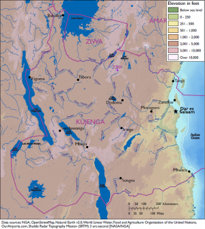
[[File:Kujenga terrain map.PNG|thumb|Physical Map of Kujenga]] | [[File:Kujenga terrain map.PNG|thumb|Physical Map of Kujenga]] | ||
Revision as of 19:59, 3 May 2018
DATE Africa > Kujenga > Physical Environment: Kujenga ←You are here
Kujenga is a large country located in central eastern Africa and is roughly rectangular in shape. It borders one major body of water: the Indian Ocean and encompasses three others, Lake Victoria, Lake Malawi, Lake Tanganika. The country’s terrain varies from a significant rift valley in the central region, high mountains and arid desert lowlands, as well as coastal plains, with climates ranging from in the east, tropical to semiarid; warm desert in the west; and humid near the coast.
Contents
Table of Physical Environment Data
| Measure | Data | Remarks |
| Total Area (sq miles) | 390,810 | Includes inland water |
| Land Area (sq miles) | 364,374 | Excludes inland water |
| Inland Water (sq miles) | 26,437 | Includes Lake Tanganyika, Lake Niassa, Lake Bangweulu, and Lake Rukwa |
| Inland Border (miles) | 3,073 | Amari (517), Ziwa (487) |
| Coastline (miles) | 2,834 | Indian Ocean (1,570), Lake Victoria (315), Lake Niassa (439), Lake Tanganyika (511) |
| Highest Elevation (ft) | 11,220 | Mt Hanang |
| Lowest Elevation (ft) | 0 | Sea level |
| Arable (cultivated) Land (%) | ||
| Permanent Crops (%) | ||
| Permanent Pasture (%) | ||
| Irrigated Land (%) | ||
| Forested Land (%) | ||
| Urban Area (%) |
Terrain
Kujenga’s area is 390,810 square miles in the eastern part of central Africa. It shares 3,073 miles of border with several different countries, including Amari and Ziwa to the north, and four major bodies of water—the Indian Ocean, Lake Victoria, Lake Tanganyika, and Lake Niassa. The country’s varied terrain includes mountainous highlands, high plateaus, deep valleys, lowland plains, and sandy beaches.
Border Disputes
The Tanga region, a small triangle of land defined by the far southeastern Amari border, the Pangani River, and the Indian Ocean formally belongs to Kujenga. However, its populace identifies with Amari, and wishes to join that country. Though the land is not disputed per se, the situation occasionally leads to political tensions between these two neighbors. Armed outbreaks occur episodically, primarily between the local populace and Kujengan security forces, though Amarian security forces have also been involved.
Bodies of Water
To be published
Mobility Classification
To be published
Natural Hazards
To be published
Subterranean Environment
To be published
Vegetation
To be published
Agriculture
To be published
Livestock and Wildlife
To be published
Climate and Weather
To be published
Seasons
To be published
Precipitation
To be published
Temperature-Heat Index
To be published
Temperature-Wind Chill Index
To be published
Relative Humidity
To be published
Wind
To be published
Summary
To be published
| DATE Africa Quick Links . | |
|---|---|
| Amari | Political • Military • Economic • Social • Information • Infrastructure • Physical Environment • Time |
| Kujenga | Political • Military • Economic • Social • Information • Infrastructure • Physical Environment • Time |
| Nyumba | Political • Military • Economic • Social • Information • Infrastructure • Physical Environment • Time |
| Ziwa | Political • Military • Economic • Social • Information • Infrastructure • Physical Environment • Time |
| Other | Non-State Threat Actors and Conditions • Criminal Activity • DATE Map References • Using The DATE |


