|
|
| Line 1: |
Line 1: |
| − | ''This page is a section of [[Nyumba]].'' | + | ''This page is a section of [[Nyumba]].'' |
| − | | + | [[File:Amari Physical thumb.gif|thumb|462x462px|Physical Map of Amari (Placeholder)]] |
| − | While the region’s five countries have a significant number of rural residents, the majority of each country’s population lives in urban areas. About two-thirds of the Arianian (68%), Donovian (67%), and Limarian populace (64%) and just over half of the Gorgan (53%) and Atropian (52%) populace live in urban areas. All five countries contain a mixture of modern urban cities and almost pre- modern rural villages. Modern utilities can be found in most major cities but not in the rural villages and countryside.
| + | Amari is a moderately large country located in eastern Africa. It borders two major bodies of water: the Indian Ocean and Lake Victoria. The country’s terrain varies from high mountains and green plateaus to desert lowlands and coastal plains, with climates ranging from tropical to semiarid to sub-alpine. Multiple natural hazards exist, resulting from Amari’s geology, weather, native wildlife, and human activity. |
| − | | |
| − | The Arianian infrastructure resembles a patchwork quilt with a mixture of modernization and obsolescence. While previous Arianian leaders made substantial investments, the infrastructure now faces significant challenges from the stresses of both war and peace. While rail, road, air, and seaports are marginally adequate, the natural gas and oil infrastructure suffers from archaic construction. Environmental and population pressures on aquifers, along with considerable pollution levels, create significant stress on water and other natural resources. Over 40% of [[Ariana|Ariana’s]] more than 77 million people reside in its 18 largest cities, all of which have at least 350,000 residents.
| |
| − | | |
| − | == Construction Patterns ==
| |
| − | As previously mentioned, the majority of residents in all five countries live in urban areas. Most urban cities contain a mixture of old neighborhoods with roughshod construction, while buildings in newer neighborhoods are made with modern construction methods. In rural villages and areas, residents use whatever materials they can obtain to build their houses.
| |
| − | | |
| − | Construction patterns in Ariana’s urban areas are similar, with dense, random construction in the city’s oldest areas and more closed orderly block construction in the recently built neighborhoods. In the very rural areas, Arianians use mud, brick and other traditional techniques that have been used to build homes for hundreds, if not thousands, of years. The result is a shantytown appearance.
| |
| − | | |
| − | Military operations in urban areas will benefit from modern electricity, water, sewage, and other utility services. The military will also find resources to support them such a large labor pool. In urban areas, the military must cope with more people who oppose them, additional hiding places for the enemy, and added civilians they must support logistically to prevent starvation. Because of its large metropolitan population, Ariana would require extensive urban operations.
| |
| − | | |
| − | == Major Arianian Cities and Urban Zones ==
| |
| − | [[File:Ariana's Largest Cities.png|thumb|Ariana's Largest Cities]] | |
| − | Over 68% percent of Ariana’s people live in urban areas. Ariana has 12 metropolitan areas with populations over one million residents. Over 40% of Ariana residents (over 34 million of 77.9 million) live in Ariana’s 18 largest metropolitan areas.
| |
| − | | |
| − | === Tehran ===
| |
| − | Tehran, Ariana’s capital, contains over one-eighth of the country’s population—over 8 million people, with an additional 4 million people in the greater metropolitan area. Tehran governs the city through 22 municipal districts. The city center is a mixture of closely compacted ancient buildings along narrow streets and modern multi-story high rise buildings that form both city core and core periphery urban zones. Tehran also has both high-rise and low-rise residential areas. Ariana’s capital possesses many commercial, industrial areas, including an oil refinery south of the city and military bases in the metropolitan area. Over 175 miles of highways cross Tehran with at least another 80 miles under construction.
| |
| − | | |
| − | === Mashhad ===
| |
| − | Mashhad, Ariana’s second-largest city with over 2.5 million residents, lies in the extreme northeast corner of the country. A complex of modern high-rise buildings under 10 stories tall and mosques in the center of Mashhad create city core and core periphery urban zones. Old-style dense, random residential houses surround the governmental complex for many miles in all directions. A few high- rise apartment buildings, most under 10 stories, are scattered among the dense low-rise residential neighborhoods.
| |
| − | | |
| − | === Isfahan ===
| |
| − | The country’s third-largest city, Isfahan, has over 1.5 million residents in the city and almost 3.5 million in the metropolitan area. Located along the main north-south and east-west routes across Ariana, Isfahan has served as an important regional city for many centuries. Like other large Arianian cities, its variety of neighborhoods includes the closely packed old city built randomly over the centuries, scattered areas with high-rise apartments, and spread-out single-family homes in more orderly construction farther from the inner city. Urban zones include city core, core periphery, and high-rise residential areas, with smaller zones of low-rise residential areas. For a city its size, Isfahan has few commercial and industrial areas. | |
| − | | |
| − | === Tabriz ===
| |
| − | Located in Ariana’s extreme northwest corner of the country, Tabriz is Ariana’s fourth-largest city with 1.5 million residents. Each of the city’s eight municipal districts contains old city neighborhoods that create small city core urban zones with dense random construction. Pockets of high-rise multi- family dwellings and single-family homes spring up randomly in all the districts, creating both high- rise and low-rise residential area urban zones. The suburbs, while planned, do not always resemble a grid pattern as the residents built the low-rise residential areas to fit the terrain. After Tehran, the greater Tabriz region is Ariana’s largest industrial center and possesses a thriving commercial area.
| |
| − | | |
| − | === Karaj ===
| |
| − | Karaj, with almost 1.4 million inhabitants, is Ariana’s fifth-largest city. Located near Tehran to the west, the city contains a similar combination of dense random construction and modern buildings that create city core, core periphery, high-rise, and low-rise residential areas. Karaj also has commercial and industrial areas.
| |
| − | | |
| − | === Population Density ===
| |
| − | Tehran: 26,748 people per square mile
| |
| − | | |
| − | Mashhad: 16,445 people per square mile
| |
| − | | |
| − | Isfahan: 12,556 people per square mile
| |
| − | | |
| − | Tabriz: 11,179 people per square mile
| |
| − | | |
| − | Karaj: 11,111 people per square mile
| |
| − | | |
| − | == Utilities Present ==
| |
| − | The Caucasus area faces a dichotomy when it comes to utilities such as electricity, water, and sewage treatment. Most urban households can access modern utilities, but rural areas cannot. Many rural residents who cannot access modern utilities live similarly to their ancestors generations ago.
| |
| − | | |
| − | === Power ===
| |
| − | Another dichotomy in the Caucasus region is that countries like Ariana, Atropia, and Donovia export hydrocarbons, coal, or electrical power to other countries while Gorgas and Limaria must import the same resources to meet their requirements. The countries that can export hydrocarbon products or electricity become richer while those that must import significant quantities of power become poorer. At least 75% of all structures in the five countries can access power because they are located in urban areas.
| |
| − | | |
| − | Though it is the fourth-largest producer of crude oil in the world, Ariana still must import over 200,000 barrels per day (bbl/day) of refined oil products because it lacks internal refinery capacity. During the past three years, Ariana reduced its natural gas exports 25%, or 50 billion cubic feet, as it attempted to wean its citizens off more expensive oil products. While Ariana increased its electricity production over the past decade by over 10%, electricity exports remain stagnant because of increased internal consumption.
| |
| − | | |
| − | Arianian population growth, inadequate power distribution investment, outdated infrastructure, and waste place significant demands on Ariana’s electrical grid. Ariana currently produces 90% of its power from oil-fired generation plants (as expected with its oil reserves), but the country is pursuing an aggressive construction program for hydroelectric dams and nuclear power plants. The first nuclear power plant hooked up to the national grid occurred in September 2011 when the Bushehr power plant went on line. With the success of the initial nuclear power plant, the Arianian government began the construction of five additional reactors—one at Bushehr and four additional sites located along the Persian Gulf. The Arianian government continues to emphasize electricity for development. Ariana exports small quantities of electricity to Limaria, Pakistan, Kalaria, Iraq, and Afghanistan.
| |
| | {| class="wikitable" | | {| class="wikitable" |
| − | |'''Name'''
| + | !Measure |
| − | |'''Location* (Latitude/Longitude)'''
| + | !Data |
| − | |'''Current Operational Reactors'''
| + | !Remarks |
| − | |'''Reactors Under Construction'''
| |
| | |- | | |- |
| − | |'''Bushehr''' | + | |'''Land Area (sq miles)''' |
| − | |N 28˚ 59’ 20” | + | |196,575 |
| − | | + | |Includes inland water |
| − | E 50˚ 49’ 42”
| + | |- |
| − | |1 | + | |'''Land Border (miles)''' |
| − | |1 | + | |3,158 |
| | + | |Kujenga (516), Nyumba (774); Ziwa (437) |
| | + | |- |
| | + | |'''Coastline (miles)''' |
| | + | |2,273 |
| | + | |Indian Ocean (817), Lake Victoria (1,312), Lake Albert (144) |
| | |- | | |- |
| − | |'''Bandar Deylam''' | + | |'''Arable (cultivated) Land (%)''' |
| − | |N 30˚ 00’ 09” | + | |37% |
| − | | + | |Primarily in the west |
| − | E 50˚ 09’ 29”
| |
| − | |0
| |
| − | |1 | |
| | |- | | |- |
| − | |'''Bandar-e-Ganaveh''' | + | |'''Highest Elevation (ft)''' |
| − | |N 29˚ 38’ 25” | + | |19,341 |
| − | | + | |Mt Kilimanjaro |
| − | E 50˚ 25’ 18”
| |
| − | |0
| |
| − | |1 | |
| | |- | | |- |
| − | |'''Banak''' | + | |'''Lowest Elevation (ft)''' |
| − | |N 27˚ 49’ 46”
| |
| − | | |
| − | E 52˚ 02’ 12”
| |
| | |0 | | |0 |
| − | |1 | + | |sea level |
| | |- | | |- |
| − | |'''Bandar-Lengeh''' | + | |'''Permanent Crops (%)''' |
| − | |N 26 ˚ 33’ 50” | + | |8% |
| − | | + | |west |
| − | E 54˚ 54’ 55”
| |
| − | |0
| |
| − | |1 | |
| | |- | | |- |
| − | | colspan="4" |'''*Estimated Location Only'''
| + | |'''Permanent Pasture (%)''' |
| | + | |35% |
| | + | |east |
| | |- | | |- |
| − | | colspan="4" |'''Arianian Nuclear Power Plants'''
| + | |'''Irrigated Land (%)''' |
| − | |} | + | |4% |
| − | The Western world will need continuous access to oil and natural gas from Ariana, which is one of the largest hydrocarbon producers in the world. Any military activity in the region will need to help ensure the continued operation of Ariana’s hydrocarbon export systems.
| + | |east |
| − | | + | |} |
| − | === Water ===
| |
| − | The majority of the Caucasus region’s urban population has access to potable water. As areas become more rural, people must rely on local sources—rivers, streams, and wells—to obtain water for cooking, drinking, and washing.
| |
| − | | |
| − | Though population increases have placed additional pressure on water delivery systems, the government has successfully extended modern water systems to reach more than 75% of Arianians. In rural areas, water distribution infrastructure is obsolete, inadequate, or nonexistent. The Arianian geography creates a dichotomy because of extreme seasonal water flow variations as well as differences between regions (from bone-dry deserts in the east and south, to the lush mountain valleys along the Caspian) and even within regions. These challenges create distribution issues that require significant investment in dams, pipelines, and reservoirs. Deep wells also serve as an important part of the water distribution network, especially in rural areas. Military personnel should find sufficient potable water access in urban areas but may experience water shortages in rural areas. Before any military personnel use local water sources, they should test and potentially treat for contamination.
| |
| | | | |
| − | === Sewage === | + | == Terrain == |
| − | The vast majority of Ariana, Atropia, Donovia, and Gorgas urban residents use modern sewage disposal methods to get rid of waste, but most Limarians do not. Urban residents have greater access to modern sewage treatment than rural residents. The more remote a person, the less likely he/she will use modern sewage treatment techniques. Poor disposal methods in rural areas contaminate ground water that other residents rely on for drinking and cooking.
| + | Amari’s land area is 196,575 square miles in the eastern part of central Africa. It shares 3,158 miles of border with several different countries, including Kujenga and Ziwa to the south and Nyumba to the north, and two major bodies of water—the Indian Ocean and Lake Victoria. The country’s varied terrain includes mountainous highlands, high plateaus, deep valleys, lowland plains, and sandy beaches. |
| | | | |
| − | While moderately capable sewage systems exist in larger metropolitan areas, sewage systems in many Arianian rural areas are outdated, inadequate, or nonexistent. In many locations—including urban areas—households and industries discharge untreated sewage through rainwater systems. In rural areas, sanitary facilities often consist of pit latrines or other very basic systems. Urban areas usually have more modern facilities. With the exception of Tehran, which has separate water and sewer departments, a single local government entity that reports to national authorities handles both water and sewage.
| + | Roughly rectangular in shape, Amari’s long axis runs northwest to southeast. Beginning at the former, Amari’s northwest border runs along the Western Rift Valley and part of Lake Albert. Steep 1,000-ft high bluffs separate the valley from the western plateau, which includes part of Lake Victoria in the south. Continuing southeast, the mountainous central highlands come next and consist of two parts—western and eastern—that are divided by the Eastern Rift Valley. The east-central highlands descend to the eastern lowlands and then to the coastal plains on the Indian Ocean. Pemba Island (340 sq miles) lies southeast of the mainland and is the country’s southernmost land mass. The highest point in Amari is Mt. Kilimanjaro at 19,341 feet, while the lowest is at sea level on the Indian Ocean coast. |
| | | | |
| − | == Transportation Architechture == | + | == Border Disputes == |
| − | Roads are the primary transportation method throughout the Caucasus region. Train and especially air travel remain too expensive for many residents of Ariana, Atropia, Gorgas, and Limaria. Most roads, especially the unpaved ones, suffer from a lack of maintenance. Ariana and Donovia maintain a complex transportation architectural system while the other three countries operate a moderate one due to railway system limitations.
| + | The Tanga region, a small triangle of land defined by the far southeastern Amari border, the Pangani River, and the Indian Ocean formally belongs to Kujenga. However, its populace identifies with Amari, and wishes to join that country. Though the land is not disputed per se, the situation occasionally leads to political tensions between these two neighbors. Armed outbreaks occur episodically, primarily between the local populace and Kujengan security forces, though Amarian security forces have also been involved. |
| − | [[File:Ariana’s Major Roads.png|thumb|Ariana’s Major Roads]]
| |
| | | | |
| − | === Road Systems === | + | == Bodies of Water == |
| − | Overall, roads in this part of the world do not meet US or Western Europe standards. Driving is hazardous, especially in the winter months or in bad weather. Generally, drivers do not obey all traffic laws, and vehicle owners often fail to maintain their vehicles properly.
| + | Amari’s most prominent bodies of water are the Indian Ocean to the east and Lake Victoria in the southwest. The country shares maritime borders on the Indian Ocean with Nyumba and Kujenga, and operates a major deepwater port at Mombasa. The ocean is a major source of fish, both for internal consumption and for export, which occasionally leads to quarrels between Amari and its neighbors. Recent discoveries of natural gas in Amarian waters could be another source of conflict. |
| | | | |
| − | Ariana has a vast road network of 106,891 miles that includes 77,893 miles of paved roads. The Arianian road network consists of two major national highways, called the A1 and the A2. The A1 stretches from the Limarian border, through Tehran, to Afghanistan. It covers 1,200 miles and is generally kept in good condition throughout its entire length. The A2 extends from the Iraqi border to the Pakistani border along the southern part of Ariana. Numerous other freeways and roads connect cities or run within major cities like Tehran. Most have heavy traffic and are considered dangerous due to the Arianians’ reckless driving habits, poor design, substandard road conditions, and poorly maintained older cars.
| + | Lake Victoria is also a major fishing resource, shared between Amari, Kujenga, and Ziwa. The second-largest lake in the world and the largest tropical freshwater lake, it covers over 26,500 square miles and reaches a maximum depth of approximately 270 feet. Used for fishing, transportation, and drinking (despite pollution issues), the lake is also the subject of occasional disputes, particularly by those living near—or making their living from—the lake. These incidents typically increase in frequency and severity during periods of extended drought, when the lake can decrease significantly in size. |
| | | | |
| − | === Bus ===
| + | Other prominent lakes in Amari include Lake Albert and Lake Kyoga. Lake Albert lies on the western border, and is shared with the country’s western neighbor. It has a surface area of around 2,100 square miles and a maximum depth of approximately 185 feet. Overfishing and pollution on the lake have decreased its usefulness to Amari in recent years, though it is used for transportation. Additionally, a recent discovery of a major petroleum deposit in the area is drawing considerable national and international interest. Lake Kyoga is located in western Amari, north of Lake Victoria and east of Lake Albert. It consists of a main east-west basin with two northern branches, known as Lake Kwania and Lake Kojweri. The entire body of water covers around 660 square miles and reaches a maximum depth of less than 25 feet. Swampy in nature, it is home to crocodiles as well as fish. Despite this, the lake is still navigable by shallow-draft steamer boats from Galiraya, on the southern shore, to its western end. |
| − | All five countries maintain some sort of bus system, but its quality depends on the country and location. The larger the city, the more likely it will operate a public bus system. Usually, intercity buses run between the larger cities, and “private” buses may also operate in some areas. Due to the relatively cheap cost of public transportation, buses remain a favorite method for local civilians to travel long distances within their country.
| |
| | | | |
| − | Buses operate throughout Ariana, providing long distance and local transportation to the civilian population. Most travelers find the Arianian bus system inexpensive and usually reliable. Often buses will leave almost every hour from the large Arianian cities to other large cities. For long distance travel, many travelers take a night bus. Mercedes, Super Luxe, and Volvo provide the bulk of the buses that operate in Ariana. Most Mercedes buses are over ten years old, with an air conditioner that no longer operates effectively. While slightly newer, many of the air conditioners in the Super Luxe models also no longer work. Due to their relative newness, the Volvos come closest to Western standards for buses with operational air conditioners. At any time on a long-distance bus trip, riders can obtain water that usually comes from melted ice.
| + | Amari’s multiple rivers can be grouped into eastern or western, depending on which side of the Eastern Rift Valley they fall on. None of these rivers are navigable by deep-draft vessels, but portions of some of them can be used by small, shallow-draft craft such as steamboats. Navigable portions are usually located near larger bodies of water, such as the Indian Ocean or Lake Victoria. In the west, the most important river is the Victoria Nile, which consists of two distinct sections. The first starts at Lake Victoria and flows northward into Lake Kyoga, while the second flows out of Lake Kyoga and into Lake Albert. Three hydropower stations, all located on the first section of the river, supply around a third of country’s electricity. |
| | | | |
| − | Tehran is the hub for the Arianian bus system. Four major inter-city bus stations operate in Tehran, taking riders to other cities both within Ariana and to other countries. Tehran also operates an internal bus system with 60 major stations and other stops throughout the city. Additionally, the city operates 10 local trolley buses.
| + | The Albert Nile flows out of Lake Albert just north of where the Victoria Nile enters, and runs northward out of the country. The river forms a portion of the border between Amari and its western neighbor. The Mara River, in the south, forms part of the border between Amari and Ziwa. Other important rivers in the western half include the Acuwa, Kafu, Katonga, Lugo, Nzoia, Page, Suam, and Turkwel. |
| | | | |
| − | Any military operation in the Tehran area that interrupts the bus system could strangle the city’s operation. The buses are vital to Tehran’s economic well-being. Any military operations in Ariana would involve inspecting buses for contraband and weapons.
| + | In the eastern part of the country, the Athi and Tsavo Rivers run primarily eastward, where they merge to form the Galani River that flows into the Indian Ocean. The Tana River forms a considerable portion of the eastern border between Amari and Nyumba to the north. It is used for irrigation and hydroelectric power. The Pangani River forms part of the border between Amari and Kunjenga in the south. The only other major river in the east is the Ewaso Ngiro, which flows northward into Nyumba. |
| − | [[File:Ariana’s Major Railroads and Ports.png|thumb|Ariana’s Major Railroads and Ports]]
| |
| | | | |
| − | === Rail === | + | == Mobility Classification == |
| − | All five Caucasus countries operate a railroad system, but they suffer many problems due to maintenance issues, non-standard equipment, criminal activity, and high cost.
| + | Movement in Amari is less restricted in the western plateau and lowland plains than in other regions. Steep escarpments separate the two Rift Valleys from their surrounding terrain; both valleys contain active volcanoes. Glaciers exist on Amari’s highest peaks, while forests and mangroves hamper movement along the coastal plains. Mountainous terrain and rough roads make it hard to transport troops and equipment overland. Multiple rivers and streams—especially in the western half to the country—also challenge mechanized and motorized movement. Roads can become flooded during the rainy season, making them impassable. These rains also greatly affect visibility for reconnaissance and air operations. Foot movement is also limited in the central highlands by the negative effects of the high altitudes. |
| | | | |
| − | Republic of Ariana Railways controls and operates the country’s 5,246 railroad-mile network. Ariana plans significant domestic railway expansion, with connections scheduled for Afghanistan, Central Asia, Iraq, Kalaria, and Pakistan. Tehran operates a metro system that the government plans to expand to meet the capital’s transportation needs, which are driven by heavy vehicle traffic and pollution.
| + | == Natural Hazards == |
| | + | Both natural disasters and manmade hazards exist in Amari. Natural disasters include flooding, earthquakes, limited volcanic activity in the Rift Valleys, landslides, windstorms, and hailstorms. Frequent droughts, including one ongoing for the past two years, can lead to famine. Violent thunderstorms with gusty winds are common on and around Lake Victoria. Water pollution is an issue, caused by urban waste, industrial waste, and contamination by pesticides and fertilizer. Overharvesting of trees for fuel led to significant deforestation and in turn soil erosion and desertification, especially in the eastern lowlands. Unexploded ordnance, including landmines, can be found in previous conflict zones. Dangerous indigenous wildlife include disease-carrying mosquitoes and tsetse flies, as well as more traditional threats: big cats (e.g., lions), crocodiles, elephants, gorillas, hippopotamuses, hyenas, rhinoceroses, warthogs, and wild dogs. |
| | | | |
| − | Because of geographical issues in a mountainous nation like Ariana, the country’s rail system accounts for only 4% of domestic passenger traffic and just over 7% of domestic freight traffic. Arianian rail consists primarily of standard gauge 1,435 millimeter (4 feet, 8½ inch) track even though some connections with neighboring countries do use broad gauge. Most Arianian locomotives operate on diesel fuel, but some have been converted to electric. The different size gauges may cause some problems if the military attempts to use the Arianian railroad system for logistical purposes or to transport large numbers of soldiers.
| + | == Subterranean Environment == |
| | + | The Amarian government has developed some underground facilities (UGFs), including structures to protect vital space program assets, bunkers for ammunition, and underground/hardened command posts. Subterranean systems used by criminal actors consist primarily of tunnels located on main smuggling routes, usually crossing the Amari-Kujenga border east of Lake Victoria. It is relatively easy to cross international borders in the region without detection, so tunnels are minimal in number and concentrated along routes more frequently patrolled by government forces. Insurgent use of such systems is minimal except in and around the Tanga region of Kujenga, where tunnels and underground rooms are used to avoid detection by local authorities. Natural caves are found throughout the country and in the Tanga region, and are used by criminals, insurgents, and local citizens alike. |
| | | | |
| − | === Air Transportation Systems === | + | == Vegetation == |
| − | All five countries maintain both paved and unpaved runways of varying distances. Many of the unpaved runways resemble nothing more than a cleared dirt path only suitable for the sturdiest of planes.
| + | Vegetation in Amari varies by topographical region. The Western Rift Valley and most of the western plateau consist primarily of savanna, with some forests in the swampy areas of the far southwest. The central highlands and Eastern Rift Valley contain most of the country’s forests, giving way to savanna in the far north and the east. The highest elevations are host to glaciers. The eastern lowlands are primarily grassland or desert scrub. The coastal plains have both grasslands and forested areas; mangrove forests grow on the coastline. Trees found in the country include both deciduous and evergreen, including species such as acacia, bamboo, baobob, cacti, candelabra, cedar, euphorbia, giant lobelia, groundsel, heath, miombo, papyrus, and podo. |
| | | | |
| − | Ariana has 133 paved and 186 unpaved runways. In addition to the airports that provide domestic service within Ariana and international connections, the country has a number of airfields that can accommodate large aircraft (C5/C17/B747). Ariana possesses enough airfields with adequate runways to support any military operation. All pilots should ensure data accuracy before attempting to land on any runway. The “map numbers” on the runway map match up with the numbers on the chart that follows it.
| + | == Agriculture == |
| − | [[File:Ariana’s Major Runways (Not All Shown).png|thumb|Ariana’s Major Runways (Not All Shown)]]
| + | Amarian agriculture employs 60% of the labor force full-time and an additional 15% part-time, producing 30% of the national GDP. The western region plays a very important role in this sector. Over one-third of Amari’s land is arable. Most farming takes place in the highlands or on the western plateau; much of the remainder of the country is either used for pasture or covered with forests or scrub vegetation. Due to reasonable rainfall, most irrigation in the country occurs in the drier eastern region. Crops produced in Amari include bananas, beans, beets, cabbages, carrots, cashews, cassava, citrus fruit, cocoa, coconut, coffee, corn, cotton, flowers, fruit, groundnuts, khale, legumes, mango, millet, oats, onions, palms (oil), peppers, pineapple, plantains, potatoes, pyrethrum, rice, sisal, sorghum, soybeans, sugarcane, sweet potato, tea, tobacco, tomatoes, turnips, vegetables, and wheat. Of these, cashews, coffee, cotton, cut flowers, pyrethrum, sisal, and tea are exported. Despite the large agricultural economy, the country does not grow enough cereal grains to feed its populace. |
| | | | |
| − | ==== Paved Runways ==== | + | == Livestock and Wildlife == |
| − | * Over 10,000 feet: 42
| + | Amarians have considerable livestock, especially in the drier regions where crop cultivation is more difficult. Common domesticated animals include bees, cattle, pigs, sheep, goats, and poultry. The country also boasts multiple types of wildlife, including aardvark, African buffalo, numerous different kinds of antelope, several species of big cat (cheetah, leopard, lion, wildcat), bush baby, crocodile, elephant, giraffe, hippopotamus, hyena, hyrax, mongoose, many types of primate (baboon, chimpanzee, gorilla, monkey), rhinoceros, warthog, wild dog, and zebra. While some of these species are only found in national parks and game reserves in Amari, others are more widespread. Many of these species are endangered and protected by Amarian law. Poaching is a continuing problem, with elephants and rhinoceroses being the most common targets. A couple of Amari’s game reserves are shared by Nyumba to the north and at times have been a source of contention because of the lack of national security forces in the parks, ivory smuggling, big game poaching, and drug trafficking occur through the border preserves. |
| − | * 8,000 to 10,000 feet: 27
| |
| − | * 5,000 to 8,000 feet: 24
| |
| − | * 3,000 to 5,000 feet: 34
| |
| − | * Under 3,000 feet: 6
| |
| | | | |
| − | ==== Unpaved Runways ==== | + | == Climate and Weather == |
| − | * Over 10,000 feet: 1
| + | Amari has a widely varied climate depending on location and altitude. The Western Rift Valley and western plateau experience a tropical wet and dry climate defined by rainy and dry seasons. The central highlands and Eastern Rift Valley are temperate (highland climate), with the highest peaks experiencing a sub-alpine climate. The far-eastern central highlands and the eastern lowlands are primarily semiarid. The coastal plains are tropical, with high temperatures and humidity throughout the year. |
| − | * 8,000 to 10,000 feet: 1
| |
| − | * 5,000 to 8,000 feet: 9
| |
| − | * 3,000 to 5,000 feet: 142
| |
| − | * Under 3,000 feet: 33
| |
| | | | |
| − | ==== Major Runways ==== | + | === Seasons === |
| − | * GRE= Graded Rolled Earth
| + | Amari’s seasons center around the long rains and the short rains, which alternate with two distinct dry seasons. Most of the country experiences the long rains from approximately March through May, the short rains during September through December, and intervening dry seasons in June through August and January through February. In the central highlands, the two rains merge into one long rainy season from March through December, with a single dry season during January through March. The hottest months are January through March, while the coolest are July through August. Temperatures usually vary more from day to night than from season to season. |
| − | * GRS=Non-graded Rolled Earth
| |
| − | * PEM=Porous European Mix
| |
| | {| class="wikitable" | | {| class="wikitable" |
| − | |'''Map #''' | + | |+Seasons for Ariana, Atropia, Gorgas, Limaria, and North Caucasus (Donovia) |
| − | |'''Elevation (Feet)'''
| + | |'''Country/Season''' |
| − | |'''Latitude (D, M, S)'''
| + | |'''Months''' |
| − | |'''Longitude (D, M, S)'''
| + | |'''Remarks''' |
| − | |'''Length (Feet)''' | |
| − | |'''Width (Feet)''' | |
| − | |'''Surface Type''' | |
| − | |-
| |
| − | |1-1
| |
| − | |10
| |
| − | |30 22 16.00 N
| |
| − | |48 13 42.00 E
| |
| − | |10170
| |
| − | |148
| |
| − | |Asphalt
| |
| − | |-
| |
| − | |1-2
| |
| − | |10
| |
| − | |30 22 16.00 N
| |
| − | |48 13 42.00 E
| |
| − | |7438
| |
| − | |115
| |
| − | |Asphalt
| |
| − | |-
| |
| − | |2
| |
| − | |2600
| |
| − | |32 56 04.19 N
| |
| − | |47 29 00.41 E
| |
| − | |6975
| |
| − | |110
| |
| − | |Asphalt
| |
| − | |-
| |
| − | |3
| |
| − | |23
| |
| − | |25 52 32.67 N
| |
| − | |55 01 58.78 E
| |
| − | |9796
| |
| − | |148
| |
| − | |Asphalt
| |
| − | |-
| |
| − | |4
| |
| − | |88
| |
| − | |30 44 43.62 N
| |
| − | |49 40 34.54 E
| |
| − | |7000
| |
| − | |148
| |
| − | |Asphalt
| |
| − | |-
| |
| − | |5
| |
| − | |64
| |
| − | |31 20 14.80 N
| |
| − | |48 45 43.70 E
| |
| − | |11155
| |
| − | |148
| |
| − | |Asphalt
| |
| − | |-
| |
| − | |6
| |
| − | |5452
| |
| − | |34 08 17.05 N
| |
| − | |49 50 50.27 E
| |
| − | |9784
| |
| − | |148
| |
| − | |Asphalt
| |
| − | |-
| |
| − | |7
| |
| − | |4315
| |
| − | |38 19 34.54 N
| |
| − | |48 25 27.89 E
| |
| − | |10823
| |
| − | |148
| |
| − | |PEM
| |
| − | |-
| |
| − | |8
| |
| − | |2037
| |
| − | |27 14 10.21 N
| |
| − | |60 43 12.12 E
| |
| − | |7649
| |
| − | |150
| |
| − | |Asphalt
| |
| − | |-
| |
| − | |9
| |
| − | |10
| |
| − | |27 28 51.95 N
| |
| − | |52 36 56.39 E
| |
| − | |11812
| |
| − | |148
| |
| − | |Asphalt
| |
| − | |-
| |
| − | |10
| |
| − | |20
| |
| − | |29 50 24.22 N
| |
| − | |50 16 21.71 E
| |
| − | |7200
| |
| − | |100
| |
| − | |Asphalt
| |
| − | |-
| |
| − | |11
| |
| − | |3084
| |
| − | |29 05 02.13 N
| |
| − | |58 27 01.43 E
| |
| − | |11625
| |
| − | |148
| |
| − | |Asphalt
| |
| − | |-
| |
| − | |12-1
| |
| − | |22
| |
| − | |27 13 05.41 N
| |
| − | |56 22 40.35 E
| |
| − | |11959
| |
| − | |148
| |
| − | |Asphalt
| |
| − | |-
| |
| − | |12-2
| |
| − | |22
| |
| − | |27 13 05.41 N
| |
| − | |56 22 40.35 E
| |
| − | |11292
| |
| − | |98
| |
| − | |Asphalt
| |
| − | |-
| |
| − | |13
| |
| − | |19
| |
| − | |27 09 29.70 N
| |
| − | |56 10 20.86 E
| |
| − | |8530
| |
| − | |115
| |
| − | |Asphalt
| |
| − | |-
| |
| − | |14
| |
| − | |67
| |
| − | |26 31 53.00 N
| |
| − | |54 49 39.00 E
| |
| − | |8203
| |
| − | |148
| |
| − | |Asphalt
| |
| − | |-
| |
| − | |15
| |
| − | |1350
| |
| − | |27 12 45.64 N
| |
| − | |54 19 06.93 E
| |
| − | |4500
| |
| − | |100
| |
| − | |Asphalt
| |
| − | |-
| |
| − | |16
| |
| − | |1175
| |
| − | |30 43 57.46 N
| |
| − | |50 06 45.97 E
| |
| − | |8210
| |
| − | |148
| |
| − | |Asphalt
| |
| − | |-
| |
| − | |17-1
| |
| − | |5041
| |
| − | |32 53 53.00 N
| |
| − | |59 15 58.00 E
| |
| − | |6903
| |
| − | |82
| |
| − | |Asphalt
| |
| − | |-
| |
| − | |17-2
| |
| − | |5041
| |
| − | |32 53 53.00 N
| |
| − | |59 15 58.00 E
| |
| − | |9424
| |
| − | |148
| |
| − | |Asphalt
| |
| − | |-
| |
| − | |18
| |
| − | |<nowiki>-7</nowiki>
| |
| − | |36 39 18.00 N
| |
| − | |52 20 57.00 E
| |
| − | |3609
| |
| − | |98
| |
| − | |Asphalt
| |
| − | |-
| |
| − | |19
| |
| − | |3543
| |
| − | |37 29 34.81 N
| |
| − | |57 18 30.20 E
| |
| − | |10700
| |
| − | |148
| |
| − | |Asphalt
| |
| − | |-
| |
| − | |20-1
| |
| − | |70
| |
| − | |28 56 41.32 N
| |
| − | |50 50 04.69 E
| |
| − | |14665
| |
| − | |148
| |
| − | |Asphalt
| |
| − | |-
| |
| − | |20-2
| |
| − | |70
| |
| − | |28 56 41.32 N
| |
| − | |50 50 04.69 E
| |
| − | |14668
| |
| − | |148
| |
| − | |Asphalt
| |
| − | |-
| |
| − | |21-1
| |
| − | |24
| |
| − | |25 26 36.00 N
| |
| − | |60 22 55.60 E
| |
| − | |9845
| |
| − | |150
| |
| − | |Asphalt
| |
| − | |-
| |
| − | |21-2
| |
| − | |24
| |
| − | |25 26 36.00 N
| |
| − | |60 22 55.60 E
| |
| − | |12421
| |
| − | |150
| |
| − | |Asphalt
| |
| − | |-
| |
| − | |22-1
| |
| − | |3600
| |
| − | |28 43 17.80 N
| |
| − | |54 26 28.80 E
| |
| − | |3969
| |
| − | |100
| |
| − | |Asphalt
| |
| − | |-
| |
| − | |22-2
| |
| − | |3600
| |
| − | |28 43 17.80 N
| |
| − | |54 26 28.80 E
| |
| − | |5260
| |
| − | |100
| |
| − | |Asphalt
| |
| − | |-
| |
| − | |23-1
| |
| − | |500
| |
| − | |32 26 04.00 N
| |
| − | |48 23 51.50 E
| |
| − | |12653
| |
| − | |115
| |
| − | |Asphalt
| |
| − | |-
| |
| − | |23-2
| |
| − | |500
| |
| − | |32 26 04.00 N
| |
| − | |48 23 51.50 E
| |
| − | |11722
| |
| − | |148
| |
| − | |Asphalt
| |
| − | |-
| |
| − | |24
| |
| − | |72
| |
| − | |31 55 18.51 N
| |
| − | |48 52 39.06 E
| |
| − | |3334
| |
| − | |160
| |
| − | |Asphalt
| |
| − | |-
| |
| − | |25-1
| |
| − | |5226
| |
| − | |32 37 15.99 N
| |
| − | |51 41 49.26 E
| |
| − | |1467
| |
| − | |97
| |
| − | |Asphalt
| |
| − | |-
| |
| − | |25-2
| |
| − | |5226
| |
| − | |32 37 15.99 N
| |
| − | |51 41 49.26 E
| |
| − | |10920
| |
| − | |140
| |
| − | |Asphalt
| |
| − | |-
| |
| − | |26-1
| |
| − | |5256
| |
| − | |32 55 44.00 N
| |
| − | |51 33 40.00 E
| |
| − | |9830
| |
| − | |148
| |
| − | |Asphalt
| |
| − | |-
| |
| − | |26-2
| |
| − | |5256
| |
| − | |32 55 44.00 N
| |
| − | |51 33 40.00 E
| |
| − | |1091
| |
| − | |40
| |
| − | |Concrete
| |
| − | |-
| |
| − | |27-1
| |
| − | |5072
| |
| − | |32 45 02.60 N
| |
| − | |51 51 42.10 E
| |
| − | |14435
| |
| − | |148
| |
| − | |Asphalt
| |
| − | |-
| |
| − | |27-2
| |
| − | |5072
| |
| − | |32 45 02.60 N
| |
| − | |51 51 42.10 E
| |
| − | |14435
| |
| − | |148
| |
| − | |Asphalt
| |
| − | |-
| |
| − | |28
| |
| − | |4261
| |
| − | |28 53 34.00 N
| |
| − | |53 43 25.00 E
| |
| − | |6502
| |
| − | |100
| |
| − | |Asphalt
| |
| − | |-
| |
| − | |29
| |
| − | |3258
| |
| − | |35 31 47.63 N
| |
| − | |51 30 29.91 E
| |
| − | |3106
| |
| − | |70
| |
| − | |Asphalt
| |
| − | |-
| |
| − | |30
| |
| − | |2394
| |
| − | |30 20 15.24 N
| |
| − | |50 49 40.67 E
| |
| − | |6070
| |
| − | |148
| |
| − | |Asphalt
| |
| − | |-
| |
| − | |31
| |
| − | |2717
| |
| − | |35 10 27.10 N
| |
| − | |52 19 23.78 E
| |
| − | |2985
| |
| − | |105
| |
| − | |Asphalt
| |
| − | |-
| |
| − | |32
| |
| − | |4187
| |
| − | |36 14 24.21 N
| |
| − | |50 02 49.62 E
| |
| − | |3675
| |
| − | |131
| |
| − | |Asphalt
| |
| − | |-
| |
| − | |33
| |
| − | |3800
| |
| − | |35 57 07.55 N
| |
| − | |50 27 02.80 E
| |
| − | |4579
| |
| − | |75
| |
| − | |Asphalt
| |
| − | |-
| |
| − | |34
| |
| − | |41
| |
| − | |26 45 04.00 N
| |
| − | |55 53 52.00 E
| |
| − | |13892
| |
| − | |148
| |
| − | |Asphalt
| |
| − | |-
| |
| − | |35
| |
| − | |150
| |
| − | |37 14 45.94 N
| |
| − | |55 05 45.20 E
| |
| − | |3276
| |
| − | |106
| |
| − | |Asphalt
| |
| − | |-
| |
| − | |36-1
| |
| − | |0
| |
| − | |36 54 34.82 N
| |
| − | |54 24 04.58 E
| |
| − | |7715
| |
| − | |148
| |
| − | |Asphalt
| |
| − | |-
| |
| − | |36-2
| |
| − | |0
| |
| − | |36 54 34.82 N
| |
| − | |54 24 04.58 E
| |
| − | |7585
| |
| − | |148
| |
| − | |Asphalt
| |
| − | |-
| |
| − | |37
| |
| − | |5715
| |
| − | |34 52 09.00 N
| |
| − | |48 33 09.00 E
| |
| − | |10593
| |
| − | |148
| |
| − | |Asphalt
| |
| − | |-
| |
| − | |38-1
| |
| − | |5551
| |
| − | |35 12 41.87 N
| |
| − | |48 39 12.65 E
| |
| − | |13009
| |
| − | |148
| |
| − | |Asphalt
| |
| − | |-
| |
| − | |38-2
| |
| − | |5551
| |
| − | |35 12 41.87 N
| |
| − | |48 39 12.65 E
| |
| − | |14351
| |
| − | |148
| |
| − | |Asphalt
| |
| − | |-
| |
| − | |38-3
| |
| − | |5551
| |
| − | |35 12 41.87 N
| |
| − | |48 39 12.65 E
| |
| − | |14625
| |
| − | |148
| |
| − | |Asphalt
| |
| − | |-
| |
| − | |38-4
| |
| − | |5551
| |
| − | |35 12 41.87 N
| |
| − | |48 39 12.65 E
| |
| − | |14625
| |
| − | |148
| |
| − | |Asphalt
| |
| − | |-
| |
| − | |39
| |
| − | |4377
| |
| − | |33 35 11.78 N
| |
| − | |46 24 17.43 E
| |
| − | |9185
| |
| − | |148
| |
| − | |Asphalt
| |
| − | |-
| |
| − | |40
| |
| − | |3350
| |
| − | |28 35 11.48 N
| |
| − | |53 34 44.90 E
| |
| − | |7947
| |
| − | |98
| |
| − | |Asphalt
| |
| − | |-
| |
| − | |41
| |
| − | |2172
| |
| − | |27 49 13.52 N
| |
| − | |52 21 07.74 E
| |
| − | |7715
| |
| − | |148
| |
| − | |Asphalt
| |
| − | |-
| |
| − | |42
| |
| − | |19
| |
| − | |25 39 12.80 N
| |
| − | |57 47 57.30 E
| |
| − | |6200
| |
| − | |148
| |
| − | |Asphalt
| |
| − | |-
| |
| − | |43
| |
| − | |2643
| |
| − | |28 43 36.93 N
| |
| − | |57 40 12.97 E
| |
| − | |7237
| |
| − | |98
| |
| − | |Asphalt
| |
| − | |-
| |
| − | |44
| |
| − | |500
| |
| − | |37 22 59.85 N
| |
| − | |55 27 07.50 E
| |
| − | |7255
| |
| − | |92
| |
| − | |Asphalt
| |
| − | |-
| |
| − | |45
| |
| − | |4170
| |
| − | |35 46 33.94 N
| |
| − | |50 49 36.07 E
| |
| − | |12005
| |
| − | |197
| |
| − | |Asphalt
| |
| − | |-
| |
| − | |46
| |
| − | |3465
| |
| − | |33 53 43.20 N
| |
| − | |51 34 37.36 E
| |
| − | |8845
| |
| − | |135
| |
| − | |Asphalt
| |
| − | |-
| |
| − | |47-1
| |
| − | |5736
| |
| − | |30 16 28.00 N
| |
| − | |56 56 04.00 E
| |
| − | |6645
| |
| − | |148
| |
| − | |Asphalt
| |
| − | |-
| |
| − | |47-2
| |
| − | |5736
| |
| − | |30 16 28.00 N
| |
| − | |56 56 04.00 E
| |
| − | |13456
| |
| − | |148
| |
| − | |Asphalt
| |
| − | |-
| |
| − | |48
| |
| − | |4284
| |
| − | |34 20 45.07 N
| |
| − | |47 09 29.25 E
| |
| − | |11214
| |
| − | |148
| |
| − | |Asphalt
| |
| − | |-
| |
| − | |49
| |
| − | |UNK
| |
| − | |27 22 46.00 N
| |
| − | |52 44 16.00 E
| |
| − | |13117
| |
| − | |UNK
| |
| − | |UNK
| |
| − | |-
| |
| − | |50
| |
| − | |17
| |
| − | |29 15 37.00 N
| |
| − | |50 19 26.00 E
| |
| − | |5922
| |
| − | |148
| |
| − | |Asphalt
| |
| − | |-
| |
| − | |51
| |
| − | |10
| |
| − | |29 15 34.68 N
| |
| − | |50 20 07.70 E
| |
| − | |UNK
| |
| − | |UNK
| |
| − | |UNK
| |
| − | |-
| |
| − | |52
| |
| − | |3790
| |
| − | |33 26 07.19 N
| |
| − | |48 16 58.77 E
| |
| − | |10499
| |
| − | |148
| |
| − | |Asphalt
| |
| − | |-
| |
| − | |53
| |
| − | |UNK
| |
| − | |38 25 20.00 N
| |
| − | |44 58 36.00 E
| |
| − | |9190
| |
| − | |UNK
| |
| − | |UNK
| |
| − | |-
| |
| − | |54-1
| |
| − | |100
| |
| − | |26 31 36.10 N
| |
| − | |53 58 54.49 E
| |
| − | |12028
| |
| − | |148
| |
| − | |Asphalt
| |
| − | |-
| |
| − | |54-2
| |
| − | |100
| |
| − | |26 31 36.10 N
| |
| − | |53 58 54.49 E
| |
| − | |11405
| |
| − | |98
| |
| − | |Asphalt
| |
| − | |-
| |
| − | |55
| |
| − | |1345
| |
| − | |27 22 21.88 N
| |
| − | |53 11 19.66 E
| |
| − | |10225
| |
| − | |98
| |
| − | |Asphalt
| |
| − | |-
| |
| − | |56-1
| |
| − | |2600
| |
| − | |27 40 23.00 N
| |
| − | |54 23 14.00 E
| |
| − | |7874
| |
| − | |98
| |
| − | |Asphalt
| |
| − | |-
| |
| − | |56-2
| |
| − | |2600
| |
| − | |27 40 23.00 N
| |
| − | |54 23 14.00 E
| |
| − | |10334
| |
| − | |148
| |
| − | |Asphalt
| |
| − | |-
| |
| − | |57
| |
| − | |73
| |
| − | |26 48 37.00 N
| |
| − | |53 21 22.00 E
| |
| − | |6800
| |
| − | |148
| |
| − | |Asphalt
| |
| − | |-
| |
| − | |58
| |
| − | |8
| |
| − | |30 33 22.29 N
| |
| − | |49 09 06.77 E
| |
| − | |8874
| |
| − | |148
| |
| − | |Asphalt
| |
| − | |-
| |
| − | |59
| |
| − | |4396
| |
| − | |37 20 55.28 N
| |
| − | |46 07 34.59 E
| |
| − | |9842
| |
| − | |98
| |
| − | |Asphalt
| |
| − | |-
| |
| − | |60-1
| |
| − | |3270
| |
| − | |36 14 06.70 N
| |
| − | |59 38 27.50 E
| |
| − | |12750
| |
| − | |148
| |
| − | |Asphalt
| |
| − | |-
| |
| − | |60-2
| |
| − | |3270
| |
| − | |36 14 06.70 N
| |
| − | |59 38 27.50 E
| |
| − | |12389
| |
| − | |148
| |
| − | |Asphalt
| |
| − | |-
| |
| − | |61-1
| |
| − | |1187
| |
| − | |32 00 08.29 N
| |
| − | |49 16 14.40 E
| |
| − | |4690
| |
| − | |98
| |
| − | |Asphalt
| |
| − | |-
| |
| − | |61-2
| |
| − | |1187
| |
| − | |32 00 08.29 N
| |
| − | |49 16 14.40 E
| |
| − | |5876
| |
| − | |98
| |
| − | |Asphalt
| |
| − | |-
| |
| − | |62
| |
| − | |<nowiki>-6</nowiki>
| |
| − | |36 51 24.73 N
| |
| − | |54 12 08.09 E
| |
| − | |3270
| |
| − | |98
| |
| − | |Asphalt
| |
| − | |-
| |
| − | |63-1
| |
| − | |3550
| |
| − | |33 05 20.30 N
| |
| − | |53 25 02.40 E
| |
| − | |4284
| |
| − | |64
| |
| − | |Asphalt
| |
| − | |-
| |
| − | |63-1
| |
| − | |3550
| |
| − | |33 05 20.30 N
| |
| − | |53 25 02.40 E
| |
| − | |4396
| |
| − | |118
| |
| − | |GRE
| |
| − | |-
| |
| − | |64
| |
| − | |<nowiki>-6</nowiki>
| |
| − | |36 39 48.00 N
| |
| − | |51 27 53.00 E
| |
| − | |6677
| |
| − | |115
| |
| − | |Asphalt
| |
| − | |-
| |
| − | |65-1
| |
| − | |85
| |
| − | |30 50 06.60 N
| |
| − | |49 32 05.70 E
| |
| − | |13500
| |
| − | |148
| |
| − | |Asphalt
| |
| − | |-
| |
| − | |65-2
| |
| − | |85
| |
| − | |30 50 06.60 N
| |
| − | |49 32 05.70 E
| |
| − | |11500
| |
| − | |148
| |
| − | |Asphalt
| |
| − | |-
| |
| − | |66
| |
| − | |251
| |
| − | |39 36 12.98 N
| |
| − | |47 52 53.40 E
| |
| − | |8515
| |
| − | |115
| |
| − | |Asphalt
| |
| − | |-
| |
| − | |67
| |
| − | |5298
| |
| − | |30 17 51.77 N
| |
| − | |56 03 04.10 E
| |
| − | |9814
| |
| − | |148
| |
| − | |Asphalt
| |
| − | |-
| |
| − | |68
| |
| − | |<nowiki>-7</nowiki>
| |
| − | |36 54 35.67 N
| |
| − | |50 40 46.52 E
| |
| − | |4921
| |
| − | |148
| |
| − | |Asphalt
| |
| | |- | | |- |
| − | |69 | + | |'''Long Rains''' |
| − | |<nowiki>-4</nowiki> | + | |March–May |
| − | |37 19 31.55 N | + | | |
| − | |49 36 20.55 E
| |
| − | |9542
| |
| − | |148
| |
| − | |Asphalt
| |
| | |- | | |- |
| − | |70 | + | |'''Dry''' |
| − | |2980 | + | |June–September |
| − | |36 10 06.28 N | + | |continued rain in the central highlands |
| − | |57 35 42.26 E
| |
| − | |10413
| |
| − | |148
| |
| − | |Asphalt
| |
| | |- | | |- |
| − | |71 | + | |'''Short Rains''' |
| − | |4522 | + | |October–December |
| − | |35 14 48.97 N | + | | |
| − | |47 00 32.44 E
| |
| − | |8190
| |
| − | |148
| |
| − | |Asphalt
| |
| | |- | | |- |
| − | |72 | + | |'''Dry''' |
| − | |945 | + | |January–February |
| − | |36 30 04.24 N | + | | |
| − | |61 03 53.65 E
| |
| − | |12720
| |
| − | |148
| |
| − | |Asphalt
| |
| − | |-
| |
| − | |73
| |
| − | |UNK
| |
| − | |27 24 30.00 N
| |
| − | |62 19 14.00 E
| |
| − | |7103
| |
| − | |UNK
| |
| − | |UNK
| |
| − | |-
| |
| − | |74
| |
| − | |35
| |
| − | |36 38 09.00 N
| |
| − | |53 11 37.00 E
| |
| − | |8688
| |
| − | |148
| |
| − | |Asphalt
| |
| − | |-
| |
| − | |75
| |
| − | |4925
| |
| − | |29 14 06.82 N
| |
| − | |53 07 38.17 E
| |
| − | |UNK
| |
| − | |UNK
| |
| − | |UNK
| |
| − | |-
| |
| − | |76
| |
| − | |3659
| |
| − | |35 23 21.80 N
| |
| − | |53 40 17.10 E
| |
| − | |11738
| |
| − | |142
| |
| − | |Asphalt
| |
| − | |-
| |
| − | |77
| |
| − | |3665
| |
| − | |35 35 27.94 N
| |
| − | |53 29 42.31 E
| |
| − | |9095
| |
| − | |152
| |
| − | |Asphalt
| |
| − | |-
| |
| − | |78
| |
| − | |6725
| |
| − | |32 17 50.00 N
| |
| − | |50 50 32.00 E
| |
| − | |10819
| |
| − | |148
| |
| − | |Asphalt
| |
| − | |-
| |
| − | |79
| |
| − | |4219
| |
| − | |36 25 31.00 N
| |
| − | |55 06 15.00 E
| |
| − | |9535
| |
| − | |148
| |
| − | |Asphalt
| |
| − | |-
| |
| − | |80-1
| |
| − | |4920
| |
| − | |29 32 21.60 N
| |
| − | |52 35 22.11 E
| |
| − | |13973
| |
| − | |148
| |
| − | |Asphalt
| |
| − | |-
| |
| − | |80-2
| |
| − | |4920
| |
| − | |29 32 21.60 N
| |
| − | |52 35 22.11 E
| |
| − | |14244
| |
| − | |148
| |
| − | |Asphalt
| |
| − | |-
| |
| − | |81
| |
| − | |5831
| |
| − | |29 33 03.36 N
| |
| − | |55 40 21.75 E
| |
| − | |12356
| |
| − | |148
| |
| − | |Asphalt
| |
| − | |-
| |
| − | |82
| |
| − | |42
| |
| − | |25 54 34.27 N
| |
| − | |54 32 21.71 E
| |
| − | |8211
| |
| − | |141
| |
| − | |Asphalt
| |
| − | |-
| |
| − | |83
| |
| − | |2312
| |
| − | |33 40 03.90 N
| |
| − | |56 53 33.63 E
| |
| − | |9977
| |
| − | |148
| |
| − | |Asphalt
| |
| − | |-
| |
| − | |84-1
| |
| − | |4459
| |
| − | |38 08 02.00 N
| |
| − | |46 14 06.00 E
| |
| − | |11537
| |
| − | |98
| |
| − | |Asphalt
| |
| − | |-
| |
| − | |84-2
| |
| − | |4459
| |
| − | |38 08 02.00 N
| |
| − | |46 14 06.00 E
| |
| − | |11825
| |
| − | |148
| |
| − | |Asphalt
| |
| − | |-
| |
| − | |85
| |
| − | |4021
| |
| − | |35 42 10.70 N
| |
| − | |51 28 30.50 E
| |
| − | |7650
| |
| − | |148
| |
| − | |Asphalt
| |
| − | |-
| |
| − | |86
| |
| − | |3750
| |
| − | |35 38 41.30 N
| |
| − | |51 22 50.50 E
| |
| − | |6000
| |
| − | |120
| |
| − | |Asphalt
| |
| − | |-
| |
| − | |87-1
| |
| − | |3307
| |
| − | |35 25 05.89 N
| |
| − | |51 08 37.80 E
| |
| − | |13769
| |
| − | |148
| |
| − | |Asphalt
| |
| − | |-
| |
| − | |87-2
| |
| − | |3307
| |
| − | |35 25 05.89 N
| |
| − | |51 08 37.80 E
| |
| − | |13769
| |
| − | |148
| |
| − | |PEM
| |
| − | |-
| |
| − | |88-1
| |
| − | |3962
| |
| − | |35 41 21.00 N
| |
| − | |51 18 48.30 E
| |
| − | |15540
| |
| − | |130
| |
| − | |Concrete
| |
| − | |-
| |
| − | |88-2
| |
| − | |3962
| |
| − | |35 41 21.00 N
| |
| − | |51 18 48.30 E
| |
| − | |13248
| |
| − | |197
| |
| − | |Asphalt
| |
| − | |-
| |
| − | |88-3
| |
| − | |3962
| |
| − | |35 41 21.00 N
| |
| − | |51 18 48.30 E
| |
| − | |13098
| |
| − | |148
| |
| − | |Asphalt
| |
| − | |-
| |
| − | |89
| |
| − | |4344
| |
| − | |37 40 05.40 N
| |
| − | |45 04 07.20 E
| |
| − | |10765
| |
| − | |148
| |
| − | |Asphalt
| |
| − | |-
| |
| − | |90
| |
| − | |5988
| |
| − | |30 42 01.62 N
| |
| − | |51 32 42.89 E
| |
| − | |8495
| |
| − | |148
| |
| − | |Asphalt
| |
| − | |-
| |
| − | |91
| |
| − | |4055
| |
| − | |31 54 22.00 N
| |
| − | |54 16 35.00 E
| |
| − | |13302
| |
| − | |148
| |
| − | |Asphalt
| |
| − | |-
| |
| − | |92
| |
| − | |1628
| |
| − | |31 05 54.00 N
| |
| − | |61 32 38.00 E
| |
| − | |9848
| |
| − | |148
| |
| − | |Asphalt
| |
| − | |-
| |
| − | |93-1
| |
| − | |4520
| |
| − | |29 28 34.30 N
| |
| − | |60 54 21.80 E
| |
| − | |13943
| |
| − | |148
| |
| − | |Asphalt
| |
| − | |-
| |
| − | |93-2
| |
| − | |4520
| |
| − | |29 28 34.30 N
| |
| − | |60 54 21.80 E
| |
| − | |13993
| |
| − | |98
| |
| − | |Asphalt
| |
| − | |-
| |
| − | |94
| |
| − | |5334
| |
| − | |36 46 25.62 N
| |
| − | |48 21 32.81 E
| |
| − | |9699
| |
| − | |148
| |
| − | |Asphalt
| |
| − | |-
| |
| − | |95
| |
| − | |5650
| |
| − | |32 19 38.53 N
| |
| − | |51 22 38.10 E
| |
| − | |7000
| |
| − | |148
| |
| − | |Asphalt
| |
| − | |-
| |
| − | |96
| |
| − | |4000
| |
| − | |35 56 37.10 N
| |
| − | |50 04 55.40 E
| |
| − | |3330
| |
| − | |100
| |
| − | |Asphalt
| |
| − | |-
| |
| − | |97
| |
| − | |3100
| |
| − | |34 59 02.16 N
| |
| − | |50 48 23.28 E
| |
| − | |11131
| |
| − | |148
| |
| − | |Asphalt
| |
| − | |-
| |
| − | |98
| |
| − | |2773
| |
| − | |34 10 09.90 N
| |
| − | |51 19 03.90 E
| |
| − | |3605
| |
| − | |135
| |
| − | |Asphalt
| |
| − | |-
| |
| − | |99
| |
| − | |6970
| |
| − | |29 59 59.97 N
| |
| − | |53 42 41.29 E
| |
| − | |4470
| |
| − | |125
| |
| − | |GRE
| |
| − | |-
| |
| − | |100
| |
| − | |4040
| |
| − | |35 46 34.63 N
| |
| − | |50 52 51.65 E
| |
| − | |3630
| |
| − | |65
| |
| − | |Asphalt
| |
| − | |-
| |
| − | |101
| |
| − | |110
| |
| − | |26 56 57.43 N
| |
| − | |56 16 09.41 E
| |
| − | |4538
| |
| − | |82
| |
| − | |Asphalt
| |
| − | |-
| |
| − | |102
| |
| − | |10
| |
| − | |30 39 51.24 N
| |
| − | |48 38 42.46 E
| |
| − | |3284
| |
| − | |130
| |
| − | |Asphalt
| |
| − | |-
| |
| − | |103-1
| |
| − | |5310
| |
| − | |32 34 01.34 N
| |
| − | |51 41 29.74 E
| |
| − | |3215
| |
| − | |75
| |
| − | |PEM
| |
| − | |-
| |
| − | |103-2
| |
| − | |5310
| |
| − | |32 34 01.34 N
| |
| − | |51 41 29.74 E
| |
| − | |6346
| |
| − | |165
| |
| − | |GRE
| |
| − | |-
| |
| − | |104
| |
| − | |2460
| |
| − | |37 37 40.30 N
| |
| − | |56 10 23.10 E
| |
| − | |9560
| |
| − | |96
| |
| − | |Asphalt
| |
| | |} | | |} |
| | | | |
| − | ==== Airports/Airlines ==== | + | === Precipitation === |
| − | Ariana’s major airports include:
| + | Precipitation in Amari varies primarily by season and latitude. Though usually taking the form of rain, snow is possible at extremely high elevations. Precipitation generally increases from north to south and with altitude. Most of the country receives 40–60 inches of precipitation per year, with some areas in the two Rift Valleys and around Lake Victoria receiving 60–80 inches. The eastern lowlands are by far the driest regions of the country, receiving only 10-40 inches annually, while the coastal plains receive 40–80 inches. |
| − | * Tehran Imam Khodadad International, a new facility 30 miles southwest of Tehran. An Arianian military subsidiary manages Imam Khodadad Airport, which serves as the primary international gateway.
| |
| − | * Tehran Mehrabad International operates within the greater Tehran metropolis on the west side of town. It traditionally served as Tehran’s international hub but has been replaced by the recently opened Imam Khodadad Airport. Mehrabad remains an important base for Arianian air force operations.
| |
| − | * The Shiraz International Airport serves Shiraz, a southern Arianian economic center.
| |
| − | * The Mashhad International Airport services the Shia holy city of Mashhad in extreme northeast Ariana, a religious destination for the global Shia population. Mashhad also is Ariana’s second largest city and lies close to the Turkmenistan and Afghanistan borders.
| |
| − | The four main Arianian airlines are AirAriana (the national flag carrier), Ariana Travelair, Magas Airline, and Hava Airline. All four operate an eclectic fleet of American, European, and Donovian aircraft and service a variety of European, Middle Eastern, and Asian destinations, along with providing domestic Arianian service. Airlines often operate aircraft procured prior to the Council of Guardians Revolution or secondhand Donovian and/or European passenger aircraft. Aircraft serviceability and safety remain problematic due to Western sanctions as the Arianian government and airlines attempt to keep these archaic planes in the air. In wartime, Ariana would likely use its domestic airline fleets as an auxiliary air force.
| |
| − | | |
| − | === Ports/Sea/River Transportation Systems ===
| |
| − | The five Caucasus countries share a diverse maritime culture. Ariana has a significant coastline and a large oceangoing fleet to export its oil. Atropia maintains ports on the Caspian Sea. Gorgas has three ports on the Black Sea that are accessible through the Bosporus Strait. Limaria is completely landlocked, with no direct access to any ocean or sea. Due to its location, Donovia has several seaports on the Black and Caspian Seas.
| |
| − | | |
| − | Ariana owns the largest tanker fleet within the Organization of Petroleum Exporting Countries (OPEC) cartel, a large merchant shipping fleet, and maintains ports on the Persian Gulf and the Strait of Hormuz. The country also maintains a number of offshore oil and gas platforms that are linked to onshore facilities through a highly complex series of pipelines. In addition to the offshore platforms, facilities at the Kharg, Lavan, and Sirri Islands maintain jetties and other facilities to swap petroleum from ocean-going tankers that are too large for standard ports to land-based pipelines. The safety of oil shipment infrastructure remains paramount as any disruption in the flow of oil to the Western world will affect America’s allies.
| |
| − | | |
| − | Ariana sustains a number of capable seaports along the Persian Gulf and Indian Ocean, including:
| |
| − | * Abaadan on the Arvand River, adjacent to Iraq
| |
| − | * Bandar-e Abbas on the Strait of Hormuz; serves as a primary Arianian Naval base
| |
| − | * Bandar-e Khodadad east of Abaadan, on the northern Arianian coast of the Persian Gulf
| |
| − | * Bandar-e Shahid Rajai in close proximity to Bandar-e Abbas
| |
| − | * Chabahar on the Indian Ocean; Ariana’s primary Indian Ocean port—chiefly a fisheries port and cargo trans-shipment point
| |
| − | * Kharg Island in the Persian Gulf, roughly half-way between Abaadan and Bandar-e Abbas; operates as a highly important site for the Arianian oil sector
| |
| − | The country also boasts four ports on the Caspian Sea, located at Anzali, Noshahr, Bandar-e Torkaman, and Neka. Due to the large number of ports available to Ariana, any military blockade would require significant naval assets. Interrupting the oil flowing through Ariana’s tanker fleet could cause significant problems to the Western world. (''See map of railroads and ports on page 2A-6-4.'')
| |
| − | [[File:Ariana’s Major Pipelines and Hydrocarbon Fields (not all shown).png|thumb|Ariana’s Major Pipelines and Hydrocarbon Fields (not all shown)]]
| |
| − | | |
| − | === Pipelines ===
| |
| − | The security of hydrocarbon pipelines will be paramount in any military operations in the region. Any disruption to the flow of crude oil and natural gas to the Western world could cause economic problems, as many modern countries rely on hydrocarbons to fuel their industries.
| |
| − | | |
| − | Ariana maintains an extensive pipeline system that connects with other nations but also serves as an essential internal link to refining and export operations. Five major pipelines represent the backbone of the oil/gas movement system, with connectivity points to the international distribution
| |
| − | | |
| − | network. Ariana maintains crude oil swap points with Kazakhstan and Turkmenistan to export its oil internationally and receives Kazakh or Turkmen oil for internal use. A 122-mile-long pipeline that will carry natural gas from Tabriz, Ariana, to Ordubad, Limaria, is currently under construction. Local pipelines move oil and gas from field production centers to refineries or transshipment points. The security of Ariana’s pipelines remains an important issue, as any disruption may affect America’s allies.
| |
| − | | |
| − | === Telecommunications Architecture ===
| |
| − | For the most part, Caucasus-region residents use cellular telephones to communicate with each other due to the lack of landline telephone infrastructure. Many residents never owned any type of telephone until they received their first cellular phone. Most can access news from either television or radio, but some rural residents have no information access via modern methods. (''See Information variable for additional details.'')
| |
| − | | |
| − | The majority of Arianian citizens can access a telephone, use the Internet, or listen to a television or radio broadcast. Ariana contains nearly as many operational telephones as people. For its population of 77.9 million, Ariana has 25 million landlines and 43 million cellular telephones. The Arianian government wants to extend service to all villages not presently connected to the telephone system. Arianian Internet use continues to climb as over 46,000 Internet hosts operate in Ariana and over 23 million Arianians can assess the Internet. The Broadcasting Corporation of Ariana (BCA) operates five nationwide networks, including a news channel, over 30 provincial channels, and several international channels. While satellite dishes remain technically illegal, Arianians are able to obtain and operate them, and receive broadcasts from about 20 Persian-language stations in foreign countries. The BCA also operates eight nationwide and numerous provincial radio networks. Arianian residents can also listen to many foreign radio stations. The military will find television and radio are excellent methods for communicating with the majority of Arianian citizens.
| |
| − | | |
| − | === Agriculture ===
| |
| − | Agriculture production still dominates the labor forces of Gorgas (55.6%) and Limaria (46.2%), but not Ariana (25%), Atropia (38.3%), or Donovia (20%). Even in the Caucasus region’s predominately agricultural countries, farming creates less than one-fourth of the country’s Gross Domestic Product (GDP). Except for Atropia, the region relies on food imports to feed its people. Any food import disruption may increase the military’s burden to feed civilians and prevent starvation.
| |
| − | | |
| − | While 25% of workers are employed in agriculture-related jobs, agriculture generates only 11% of Ariana’s GDP. While 9.9% of Arianian land is farmable, less than one-quarter of that amount is cultivated due to issues with salinity, irrigation, and other related infrastructure. Ariana irrigates one-third of its productive farm land. Cereal crops (wheat, barley, and rice) cover almost 70% of the cultivated land, with wheat alone as 52% of the cereal crops. Other important crops include pistachios, grapes, dates, citrus fruits, and apples. Because of availability issues, the military probably cannot rely on locally-produced foodstuffs to supplement the ration system.
| |
| − | | |
| − | === Industry ===
| |
| − | Because of their hydrocarbon resources, Ariana, Atropia, and Donovia are more industrialized than Gorgas and Limaria. Industry GDP ranges from a low of 27.1% in Gorgas to a high of 61.4% in Atropia. Ariana’s industry accounts for 45.9% of its GDP. The protection of the hydrocarbon infrastructure remains paramount for any military operations in the area, and the military should refrain from unnecessary damage to the industrial sector to facilitate economic recovery after the end of hostilities. Ariana produces a large amount of toxic industrial chemicals for multiple purposes, including hydrocarbon production activities, water purification, wastewater management, and fertilizer to increase agricultural output.
| |
| − | | |
| − | ==== Oil/Gas ====
| |
| − | Despite its position as a global force in the world’s oil and gas economy, uneven investment and a lack of modern infrastructure hinder the Arianian oil and gas industry. While Ariana has some of the largest known oil and gas reserves in the world, it lacks the ability to adequately refine the petroleum it produces. The Ariana State Oil Company (ASOC) is the world’s second largest oil company, after Saudi Aramco, and maintains access to some of the world’s largest proven reserves. The vast majority of Arianian oil and gas fields lie in Ariana’s southwest coastal area. The ASOC operates a massive organization that controls most, if not all, of Ariana’s important oil and gas production and logistical support elements. The ASOC generates most of Ariana’s revenue. Ariana currently only produces four million bbl/day compared to six million bbl/d before the Revolution. The reduction is due to combined effects of damage from the Ariana-Iraq War, a lack of infrastructure investment, and Western sanctions. Because of a refinery capacity shortage and high levels of domestic use (like gasoline), Ariana functions as a net petroleum importer. Some consider Ariana’s lack of refining capability as a significant Achilles heel for its economy. The Arianian government recently earmarked $15 billion for refinery modernization and development, but even this massive investment may not eliminate the Arianian refinery shortfall.
| |
| | | | |
| − | Ariana’s major refineries include:
| + | === Temperature-Heat Index === |
| − | * Abaadan (400,000 bbl/d capacity)
| + | Monthly average high temperatures in Amari vary with elevation. Most of the country enjoys highs between 70–85°F, with the extreme elevations—above 8,000 feet—being cooler than this. Average highs in the eastern lowlands, the coastal plains, and the far north are hotter, ranging from 80–100°F. The combination of high temperatures and moderate to high relative humidity can quickly lead to both dehydration and heat exhaustion in the regions with lower altitudes. |
| − | * Isfahan (265,000 bbl/d)
| |
| − | * Bandar-e Abbas (232,000 bbl/d)
| |
| − | * Tehran (225,000 bbl/d)
| |
| − | * Arak (150,000 bbl/d)
| |
| − | * Tabriz (112,000 bbl/d)
| |
| − | Minor refineries include:
| |
| − | * Kermancha
| |
| − | * Shiraz
| |
| − | * Lavan Island
| |
| − | Ariana plans additional refineries, modernization, or expansion at the following locations:
| |
| − | * Bandar-e Abbas
| |
| − | * Abaadan
| |
| − | Arianian oil and gas exploitation capability will drive the country’s economy for the indefinite future. Authorities will need to continue balancing oil and gas reinvestment requirements with the need for oil and gas to provide financial security for the rest of the country’s economy.
| |
| | | | |
| − | ==== Defense Industries ==== | + | === Temperature-Wind Chill Index === |
| − | In the last decade, Ariana took significant steps to create a domestic arms and military equipment manufacturing capability. The government took great pains to demonstrate its ability to indigenously produce aircraft and other high-profile items, and more importantly, Ariana reverse-engineered and produced Arianian versions of capable weapons such as the AH-1J Cobra helicopter gunship (referred to as the Panha 2091 by the Arianians) and the TOW antitank missile. The Arianians also attempted to provide depot and higher level maintenance for their aircraft through a variety of aviation companies, many owned by the Arianian government or senior Arianian military leaders.
| + | Monthly average low temperatures in the highlands and plateau fall in the 40–55°F range, though lower temperatures can occur. The lowlands are warmer than this, while elevations over 8,000 feet may experience sub-zero temperatures and snow. The highest peaks in the country possesses a permanent snow cap. Cold and wind chill will not be an issue in the lower elevations, but can affect troops operating in the highlands. |
| | | | |
| − | Ariana’s four important defense industry organizations are:
| + | === Relative Humidity === |
| − | * '''''Ariana Combat Systems Company''''': manufactures a wide range of ground and naval combat systems, from small arms to light naval combat systems
| + | Relative humidity in Amari is moderate to high in most regions. Average annual humidity in the Western Rift Valley and western plateau usually ranges from 65–80%, with level in the north and east being lower. Levels in the central highlands and Eastern Rift Valley average 55–70%, with higher altitudes experiencing higher relative humidity and vice versa. Averages in the eastern lowlands are also 55–70%, while those in the coastal plains are 65–80%. |
| − | * '''''Ariana Electronics Company''''': produces radar, telecommunications, optics, electronic warfare, and related systems; organizationally subordinate to the Ariana Combat Systems Company
| |
| − | * '''''Defense Aviation Corporation''''': provides aircraft maintenance, component replacement, and overhaul
| |
| − | * '''''Aerospace Industries of Ariana''''': concerned with ballistic missile and rocket design, manufacturing, testing, and production
| |
| − | The Arianian defense industry has attempted to build an indigenous industry capable of simultaneously producing advanced equipment for its own forces and exporting weapons abroad. While UN sanctions limit Ariana’s ability to export weapons, the country’s engineers successfully developed sophisticated systems, such as battlefield radars and missile technology, for foreign sale and domestic use. The Arianian Shahab-3, developed with Donovian, North Korean, and Chinese assistance, offers Arianian leaders a capable intermediate-range missile. Arianian engineers reportedly are planning to reverse-engineer Donovian rocket motor designs to develop a new intercontinental ballistic missile (ICBM) with a range of 3,107 miles that could target most of Europe with a nuclear warhead.
| |
| | | | |
| − | ==== Nuclear ==== | + | === Wind === |
| − | The Arianian nuclear program began in the 1950s as a research- and medical isotope-oriented program under the Pasha. With US support, the Pasha intended to eventually mature the activities into a large nuclear power program. In the aftermath of the Council of Guardians Revolution, however, the nuclear program went dormant in the 1980s, with little activity in the midst of the eight-year Ariana-Iraq War. In the early 1990s—with foreign technical assistance from Argentina, China, Donovia, and Germany—the nascent Arianian nuclear program blossomed from an almost abandoned and forgotten imperial legacy to a primary element of Ariana’s internal and external political and military arenas. Open source reporting suggests that a shadow organization, the Arianian Energy Commission (AEC), functions as the center of the Arianian nuclear program. Qabil Bagheri, an Arianian military officer and university lecturer, leads the AEC. AEC is the latest name for the Arianian clandestine nuclear weapons development program that Arianians refer to as the “Energy Research Center” or the “Special Contingencies Organization.”
| + | Wind patterns change with the seasons in Amari and are associated with the dry seasons. The Kuzi monsoon winds blow from the southeast and peaks during the months of June through August. The winds then shift to the gentler northeast Kaskazi, which peak from December through March. Average wind speeds are less than 15 mph throughout most of the country. Though calmer when transitioning during the rainy seasons, the winds are strong enough to develop wind energy in certain areas. Thunderstorms with gusty winds are a frequent occurrence around Lake Victoria. |
| − | | |
| − | In 2002, more troubling aspects of the Arianian nuclear program came to light with the public exposure of the Arianian nuclear facilities at Natanz (a uranium enrichment facility) and Arak (a heavy water reactor), whose very existence indicated a significant nuclear weapons program. Recently, Ariana became the tenth country in the world to develop a nuclear weapon. Though less powerful in terms of kilowatts compared with other nuclear powers, Ariana now possesses a small number of tactical nuclear weapons.
| |
| − | | |
| − | To make the nuclear situation in Ariana even more challenging, it has been reported that Ariana has moved a significant portion of its nuclear enrichment programs and nuclear development programs below ground into underground facilities (UGFs). It is likely that the most important UGFs associated with these activities are located at Qom, Isfahan, and Natanz.
| |
| − | | |
| − | ==== Space ====
| |
| − | The Arianian government has launched an ambitious national space program to significantly increase Arianian prestige and technical capability. The Arianian national space program will provide an internationally acceptable means for Ariana to validate much of its long-range missile technology if it produces space launch vehicles (SLVs). Dual-use technology such as satellite-based communications, earth observation/remote sensing, and scientific experiments can also produce direct military spinoffs and applications. | |
| − | | |
| − | The Arianian Space Agency, the government organization with primary responsibility for space operations, maintains a variety of current operational and developmental launchers and payloads. The Safir-2 SLV is the Arianians’ current primary operational launcher, with the potential ability (with Safir-2 follow-ons) to put 300+ kilogram satellites into low-earth orbit. The Arianians have placed a variety of payloads in orbit, including first-generation communications, photographic, and scientific missions. Many of these assets were launched using a space launch facility located just south of the town in northeastern Ariana called Sharood. This facility is relatively new and under construction. Unique characteristics of the Sharood launch facility include a launch tower that is 23 meters high, a launch pad that measures 140 meters by 200 meters, and a single rocket exhaust shaft measuring 125 meters. Given Ariana’s interest and investment in this arena, it will likely attempt to continue upgrading rocket and satellite capabilities and complexities.
| |
| − | | |
| − | ==== Pollution ====
| |
| − | All five Caucasus-region countries face significant pollution problems stemming from poor industrial practices. The governments cared more about natural resource extraction and product production than the stewardship of the planet. This lack of concern for the environment occurred regardless of which government was in power. While the Western world greatly influenced Arianian oil and natural gas production techniques, the lack of spare parts since the Revolution created excess pollution. The region’s military operations will need to address pollution, with soldiers taking precautions due to high levels of air pollution and units considering any local water source not potable until tested.
| |
| − | | |
| − | Ariana faces significant concerns regarding pollution from byproducts of industrialization, urbanization, and oil production. Due to vehicle air pollution, Tehran ranks as one of the most polluted cities in the world.
| |
| | | | |
| | == Summary == | | == Summary == |
| − | Ariana’s oil and gas infrastructure does not operate at optimal efficiency due to a broad mix of equipment and technology from several foreign countries and a lack of spare parts for some of its Western equipment. The Arianian hydrocarbon industry continues to rely on technology that is over 40 years old and susceptible to mechanical breakdown. While Ariana continues to build new infrastructure mainly in the form of pipelines to transport oil and natural gas around its country, the government spends its money on these new projects while failing to maintain the hydrocarbon infrastructure already in place.
| + | Amari’s terrain varies from rocky highland areas to flat lowland plains. The country’s rugged highlands create an obstacle for regional communication and make transport difficult. Natural disasters such as flood and drought will complicate missions. Troops must deal with extreme temperatures in the eastern lowlands, and high altitudes in parts of the central highlands. The spring-like weather in large portions of the highlands and western plateau will facilitate operations and maneuverability, as will the ease of mobility in the eastern lowlands. |
| − | | + | {{:Africa Linkbox}} |
| | [[Category:DATE]] | | [[Category:DATE]] |
| | [[Category:Africa]] | | [[Category:Africa]] |
| − | [[Category:Nyumba]]
| |
| | [[Category:Physical Environment]] | | [[Category:Physical Environment]] |
This page is a section of Nyumba.
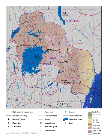
Physical Map of Amari (Placeholder)
Amari is a moderately large country located in eastern Africa. It borders two major bodies of water: the Indian Ocean and Lake Victoria. The country’s terrain varies from high mountains and green plateaus to desert lowlands and coastal plains, with climates ranging from tropical to semiarid to sub-alpine. Multiple natural hazards exist, resulting from Amari’s geology, weather, native wildlife, and human activity.
| Measure
|
Data
|
Remarks
|
| Land Area (sq miles)
|
196,575
|
Includes inland water
|
| Land Border (miles)
|
3,158
|
Kujenga (516), Nyumba (774); Ziwa (437)
|
| Coastline (miles)
|
2,273
|
Indian Ocean (817), Lake Victoria (1,312), Lake Albert (144)
|
| Arable (cultivated) Land (%)
|
37%
|
Primarily in the west
|
| Highest Elevation (ft)
|
19,341
|
Mt Kilimanjaro
|
| Lowest Elevation (ft)
|
0
|
sea level
|
| Permanent Crops (%)
|
8%
|
west
|
| Permanent Pasture (%)
|
35%
|
east
|
| Irrigated Land (%)
|
4%
|
east
|
Terrain
Amari’s land area is 196,575 square miles in the eastern part of central Africa. It shares 3,158 miles of border with several different countries, including Kujenga and Ziwa to the south and Nyumba to the north, and two major bodies of water—the Indian Ocean and Lake Victoria. The country’s varied terrain includes mountainous highlands, high plateaus, deep valleys, lowland plains, and sandy beaches.
Roughly rectangular in shape, Amari’s long axis runs northwest to southeast. Beginning at the former, Amari’s northwest border runs along the Western Rift Valley and part of Lake Albert. Steep 1,000-ft high bluffs separate the valley from the western plateau, which includes part of Lake Victoria in the south. Continuing southeast, the mountainous central highlands come next and consist of two parts—western and eastern—that are divided by the Eastern Rift Valley. The east-central highlands descend to the eastern lowlands and then to the coastal plains on the Indian Ocean. Pemba Island (340 sq miles) lies southeast of the mainland and is the country’s southernmost land mass. The highest point in Amari is Mt. Kilimanjaro at 19,341 feet, while the lowest is at sea level on the Indian Ocean coast.
Border Disputes
The Tanga region, a small triangle of land defined by the far southeastern Amari border, the Pangani River, and the Indian Ocean formally belongs to Kujenga. However, its populace identifies with Amari, and wishes to join that country. Though the land is not disputed per se, the situation occasionally leads to political tensions between these two neighbors. Armed outbreaks occur episodically, primarily between the local populace and Kujengan security forces, though Amarian security forces have also been involved.
Bodies of Water
Amari’s most prominent bodies of water are the Indian Ocean to the east and Lake Victoria in the southwest. The country shares maritime borders on the Indian Ocean with Nyumba and Kujenga, and operates a major deepwater port at Mombasa. The ocean is a major source of fish, both for internal consumption and for export, which occasionally leads to quarrels between Amari and its neighbors. Recent discoveries of natural gas in Amarian waters could be another source of conflict.
Lake Victoria is also a major fishing resource, shared between Amari, Kujenga, and Ziwa. The second-largest lake in the world and the largest tropical freshwater lake, it covers over 26,500 square miles and reaches a maximum depth of approximately 270 feet. Used for fishing, transportation, and drinking (despite pollution issues), the lake is also the subject of occasional disputes, particularly by those living near—or making their living from—the lake. These incidents typically increase in frequency and severity during periods of extended drought, when the lake can decrease significantly in size.
Other prominent lakes in Amari include Lake Albert and Lake Kyoga. Lake Albert lies on the western border, and is shared with the country’s western neighbor. It has a surface area of around 2,100 square miles and a maximum depth of approximately 185 feet. Overfishing and pollution on the lake have decreased its usefulness to Amari in recent years, though it is used for transportation. Additionally, a recent discovery of a major petroleum deposit in the area is drawing considerable national and international interest. Lake Kyoga is located in western Amari, north of Lake Victoria and east of Lake Albert. It consists of a main east-west basin with two northern branches, known as Lake Kwania and Lake Kojweri. The entire body of water covers around 660 square miles and reaches a maximum depth of less than 25 feet. Swampy in nature, it is home to crocodiles as well as fish. Despite this, the lake is still navigable by shallow-draft steamer boats from Galiraya, on the southern shore, to its western end.
Amari’s multiple rivers can be grouped into eastern or western, depending on which side of the Eastern Rift Valley they fall on. None of these rivers are navigable by deep-draft vessels, but portions of some of them can be used by small, shallow-draft craft such as steamboats. Navigable portions are usually located near larger bodies of water, such as the Indian Ocean or Lake Victoria. In the west, the most important river is the Victoria Nile, which consists of two distinct sections. The first starts at Lake Victoria and flows northward into Lake Kyoga, while the second flows out of Lake Kyoga and into Lake Albert. Three hydropower stations, all located on the first section of the river, supply around a third of country’s electricity.
The Albert Nile flows out of Lake Albert just north of where the Victoria Nile enters, and runs northward out of the country. The river forms a portion of the border between Amari and its western neighbor. The Mara River, in the south, forms part of the border between Amari and Ziwa. Other important rivers in the western half include the Acuwa, Kafu, Katonga, Lugo, Nzoia, Page, Suam, and Turkwel.
In the eastern part of the country, the Athi and Tsavo Rivers run primarily eastward, where they merge to form the Galani River that flows into the Indian Ocean. The Tana River forms a considerable portion of the eastern border between Amari and Nyumba to the north. It is used for irrigation and hydroelectric power. The Pangani River forms part of the border between Amari and Kunjenga in the south. The only other major river in the east is the Ewaso Ngiro, which flows northward into Nyumba.
Mobility Classification
Movement in Amari is less restricted in the western plateau and lowland plains than in other regions. Steep escarpments separate the two Rift Valleys from their surrounding terrain; both valleys contain active volcanoes. Glaciers exist on Amari’s highest peaks, while forests and mangroves hamper movement along the coastal plains. Mountainous terrain and rough roads make it hard to transport troops and equipment overland. Multiple rivers and streams—especially in the western half to the country—also challenge mechanized and motorized movement. Roads can become flooded during the rainy season, making them impassable. These rains also greatly affect visibility for reconnaissance and air operations. Foot movement is also limited in the central highlands by the negative effects of the high altitudes.
Natural Hazards
Both natural disasters and manmade hazards exist in Amari. Natural disasters include flooding, earthquakes, limited volcanic activity in the Rift Valleys, landslides, windstorms, and hailstorms. Frequent droughts, including one ongoing for the past two years, can lead to famine. Violent thunderstorms with gusty winds are common on and around Lake Victoria. Water pollution is an issue, caused by urban waste, industrial waste, and contamination by pesticides and fertilizer. Overharvesting of trees for fuel led to significant deforestation and in turn soil erosion and desertification, especially in the eastern lowlands. Unexploded ordnance, including landmines, can be found in previous conflict zones. Dangerous indigenous wildlife include disease-carrying mosquitoes and tsetse flies, as well as more traditional threats: big cats (e.g., lions), crocodiles, elephants, gorillas, hippopotamuses, hyenas, rhinoceroses, warthogs, and wild dogs.
Subterranean Environment
The Amarian government has developed some underground facilities (UGFs), including structures to protect vital space program assets, bunkers for ammunition, and underground/hardened command posts. Subterranean systems used by criminal actors consist primarily of tunnels located on main smuggling routes, usually crossing the Amari-Kujenga border east of Lake Victoria. It is relatively easy to cross international borders in the region without detection, so tunnels are minimal in number and concentrated along routes more frequently patrolled by government forces. Insurgent use of such systems is minimal except in and around the Tanga region of Kujenga, where tunnels and underground rooms are used to avoid detection by local authorities. Natural caves are found throughout the country and in the Tanga region, and are used by criminals, insurgents, and local citizens alike.
Vegetation
Vegetation in Amari varies by topographical region. The Western Rift Valley and most of the western plateau consist primarily of savanna, with some forests in the swampy areas of the far southwest. The central highlands and Eastern Rift Valley contain most of the country’s forests, giving way to savanna in the far north and the east. The highest elevations are host to glaciers. The eastern lowlands are primarily grassland or desert scrub. The coastal plains have both grasslands and forested areas; mangrove forests grow on the coastline. Trees found in the country include both deciduous and evergreen, including species such as acacia, bamboo, baobob, cacti, candelabra, cedar, euphorbia, giant lobelia, groundsel, heath, miombo, papyrus, and podo.
Agriculture
Amarian agriculture employs 60% of the labor force full-time and an additional 15% part-time, producing 30% of the national GDP. The western region plays a very important role in this sector. Over one-third of Amari’s land is arable. Most farming takes place in the highlands or on the western plateau; much of the remainder of the country is either used for pasture or covered with forests or scrub vegetation. Due to reasonable rainfall, most irrigation in the country occurs in the drier eastern region. Crops produced in Amari include bananas, beans, beets, cabbages, carrots, cashews, cassava, citrus fruit, cocoa, coconut, coffee, corn, cotton, flowers, fruit, groundnuts, khale, legumes, mango, millet, oats, onions, palms (oil), peppers, pineapple, plantains, potatoes, pyrethrum, rice, sisal, sorghum, soybeans, sugarcane, sweet potato, tea, tobacco, tomatoes, turnips, vegetables, and wheat. Of these, cashews, coffee, cotton, cut flowers, pyrethrum, sisal, and tea are exported. Despite the large agricultural economy, the country does not grow enough cereal grains to feed its populace.
Livestock and Wildlife
Amarians have considerable livestock, especially in the drier regions where crop cultivation is more difficult. Common domesticated animals include bees, cattle, pigs, sheep, goats, and poultry. The country also boasts multiple types of wildlife, including aardvark, African buffalo, numerous different kinds of antelope, several species of big cat (cheetah, leopard, lion, wildcat), bush baby, crocodile, elephant, giraffe, hippopotamus, hyena, hyrax, mongoose, many types of primate (baboon, chimpanzee, gorilla, monkey), rhinoceros, warthog, wild dog, and zebra. While some of these species are only found in national parks and game reserves in Amari, others are more widespread. Many of these species are endangered and protected by Amarian law. Poaching is a continuing problem, with elephants and rhinoceroses being the most common targets. A couple of Amari’s game reserves are shared by Nyumba to the north and at times have been a source of contention because of the lack of national security forces in the parks, ivory smuggling, big game poaching, and drug trafficking occur through the border preserves.
Climate and Weather
Amari has a widely varied climate depending on location and altitude. The Western Rift Valley and western plateau experience a tropical wet and dry climate defined by rainy and dry seasons. The central highlands and Eastern Rift Valley are temperate (highland climate), with the highest peaks experiencing a sub-alpine climate. The far-eastern central highlands and the eastern lowlands are primarily semiarid. The coastal plains are tropical, with high temperatures and humidity throughout the year.
Seasons
Amari’s seasons center around the long rains and the short rains, which alternate with two distinct dry seasons. Most of the country experiences the long rains from approximately March through May, the short rains during September through December, and intervening dry seasons in June through August and January through February. In the central highlands, the two rains merge into one long rainy season from March through December, with a single dry season during January through March. The hottest months are January through March, while the coolest are July through August. Temperatures usually vary more from day to night than from season to season.
Seasons for Ariana, Atropia, Gorgas, Limaria, and North Caucasus (Donovia)
| Country/Season
|
Months
|
Remarks
|
| Long Rains
|
March–May
|
|
| Dry
|
June–September
|
continued rain in the central highlands
|
| Short Rains
|
October–December
|
|
| Dry
|
January–February
|
|
Precipitation
Precipitation in Amari varies primarily by season and latitude. Though usually taking the form of rain, snow is possible at extremely high elevations. Precipitation generally increases from north to south and with altitude. Most of the country receives 40–60 inches of precipitation per year, with some areas in the two Rift Valleys and around Lake Victoria receiving 60–80 inches. The eastern lowlands are by far the driest regions of the country, receiving only 10-40 inches annually, while the coastal plains receive 40–80 inches.
Temperature-Heat Index
Monthly average high temperatures in Amari vary with elevation. Most of the country enjoys highs between 70–85°F, with the extreme elevations—above 8,000 feet—being cooler than this. Average highs in the eastern lowlands, the coastal plains, and the far north are hotter, ranging from 80–100°F. The combination of high temperatures and moderate to high relative humidity can quickly lead to both dehydration and heat exhaustion in the regions with lower altitudes.
Temperature-Wind Chill Index
Monthly average low temperatures in the highlands and plateau fall in the 40–55°F range, though lower temperatures can occur. The lowlands are warmer than this, while elevations over 8,000 feet may experience sub-zero temperatures and snow. The highest peaks in the country possesses a permanent snow cap. Cold and wind chill will not be an issue in the lower elevations, but can affect troops operating in the highlands.
Relative Humidity
Relative humidity in Amari is moderate to high in most regions. Average annual humidity in the Western Rift Valley and western plateau usually ranges from 65–80%, with level in the north and east being lower. Levels in the central highlands and Eastern Rift Valley average 55–70%, with higher altitudes experiencing higher relative humidity and vice versa. Averages in the eastern lowlands are also 55–70%, while those in the coastal plains are 65–80%.
Wind
Wind patterns change with the seasons in Amari and are associated with the dry seasons. The Kuzi monsoon winds blow from the southeast and peaks during the months of June through August. The winds then shift to the gentler northeast Kaskazi, which peak from December through March. Average wind speeds are less than 15 mph throughout most of the country. Though calmer when transitioning during the rainy seasons, the winds are strong enough to develop wind energy in certain areas. Thunderstorms with gusty winds are a frequent occurrence around Lake Victoria.
Summary
Amari’s terrain varies from rocky highland areas to flat lowland plains. The country’s rugged highlands create an obstacle for regional communication and make transport difficult. Natural disasters such as flood and drought will complicate missions. Troops must deal with extreme temperatures in the eastern lowlands, and high altitudes in parts of the central highlands. The spring-like weather in large portions of the highlands and western plateau will facilitate operations and maneuverability, as will the ease of mobility in the eastern lowlands.

